Weather
NJ Weather: Winter Storm Watch As Snow Estimates Increase
Much of the state is under a winter storm watch now that the weekend storm's snow estimates have increased.


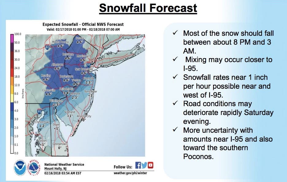
Much of New Jersey is under a winter storm watch now that the weekend storm's snow estimates have increased (see below). Some parts of the state could get as many as 6 inches of snow, as much an an inch per hour could fall.
The National Weather Service has issued a winter storm watch for the northern and central parts of the state, while the Jersey Shore and most of South Jersey have been issued a hazardous weather outlook. The storm is supposed to mostly start after 7 p.m. on Saturday and last into Sunday morning.
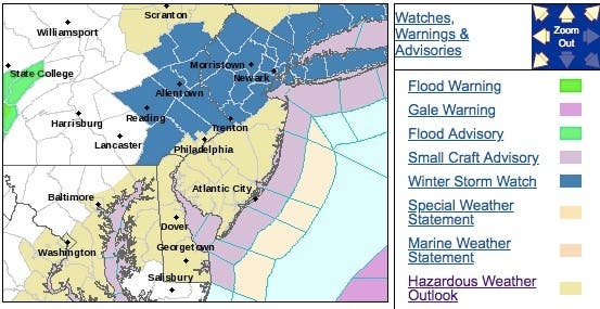
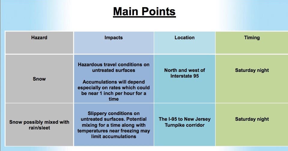
In those counties impacted by the winter storm watch, heavy snow is possible. Total snow accumulations of 4 to 6 inches are possible. The winter storm watch is in effect from 7 p.m. on Saturday until 5 a.m. on Sunday.
Find out what's happening in Point Pleasantfor free with the latest updates from Patch.
Significant reductions in visibility are possible. There is the potential for a short period of heavy snow Saturday night which could lead to a rapid deterioration in road conditions.
The snow could be wet enough especially closer to I-95 and the New Jersey Turnpike, potentially resulting in some power outages, according to the National Weather Service.
Find out what's happening in Point Pleasantfor free with the latest updates from Patch.
At the Jersey Shore and in South Jersey, some wet snow is possible later Saturday afternoon and evening before mixing with and changing to all rain. A slushy coating of snow is possible for some areas, according to the NWS.
Here are the revised snow estimates for the state – the projections have increased from the earlier estimates of 3 to 4 inches:
The NWS also said:
- Snowfall rates may reach 1 inch per hour for a time Saturday evening from about the I-95 corridor on westward.
- Snow accumulations will depend on surface temperatures and the snowfall rates. Lower confidence with snow amounts for interior New Jersey south of 195 due to some possible mixing/rain.
- The Lehigh Valley to the southern Poconos into northwestern New Jersey could be on the western fringe, which could result in lower amounts.
- A winter storm watch was issued for areas where greater impacts are possible due to a quick hitting plowable snow and colder temperatures.
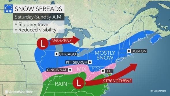
Fast movement of the storm will limit snowfall to a light to moderate amount in most cases. In most areas, the storm will last 6-8 hours. The bulk of the storm and most of the accumulation is projected to occur during Saturday night, according to AccuWeather
As the storm ramps up and spreads eastward during Saturday afternoon and night, airline delays are likely to mount due to deicing operations, according to AccuWeather. During Saturday night, where snow falls, air and road surface temperatures will lower substantially even in many of the urban areas. Roads will transition from wet to slushy and snow-covered.
Motorists heading out Sunday morning for work or religious services will have to clean off their vehicle and are likely to encounter slippery and slushy conditions, according to AccuWeather.
Here is the forecast:
- Friday: Showers. High near 56. Light west wind becoming northwest 6 to 11 mph in the afternoon. Chance of precipitation is 90%. New precipitation amounts of less than a tenth of an inch possible.
- Friday night: A chance of showers before 7pm. Mostly cloudy, then gradually becoming mostly clear, with a low around 25. Northwest wind 7 to 13 mph. Chance of precipitation is 30%. New precipitation amounts of less than a tenth of an inch possible.
- Saturday: Increasing clouds, with a high near 40. Calm wind becoming southeast 5 to 8 mph in the afternoon.
- Saturday night: Snow, mainly between 8pm and 5am. Low around 30. Southeast wind 5 to 7 mph becoming calm in the evening. Chance of precipitation is 90%. New snow accumulation of 3 to 6 inches possible.
- Sunday: A chance of snow before 8am. Mostly sunny, with a high near 46. West wind 6 to 8 mph. Chance of precipitation is 30%. New snow accumulation of less than a half inch possible.
- Sunday night: Mostly clear, with a low around 32.
Hoboken Patch photo
Get more local news delivered straight to your inbox. Sign up for free Patch newsletters and alerts.


