Weather
'Rapidly Intensifying' Winter Storm Possible For NJ
A storm that some forecasters are calling a "nor'easter" could impact your area this week. Here's how.


A rapidly intensifying storm may impact New Jersey with snow or rain Monday and Monday night, according to the National Weather Service.
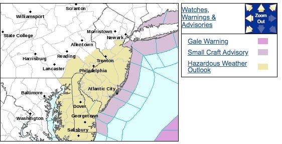
A hazardous weather outlook has been issued for Central Jersey, South Jersey and the Jersey Shore. At this point, there is a lot of uncertainty about snow totals, which will depend on the storms track as well as surface temperatures, according to the NWS.
Find out what's happening in Point Pleasantfor free with the latest updates from Patch.
AccuWeather is calling the storm a nor'easter that's poised to bring snow, rain and wind to the mid-Atlantic by early week. If so, it would be the third nor'easter to impact New Jersey in two weeks.
In a release, AccuWeather said the storm is likely to track close enough and strengthen enough to bring accumulating snow, drenching rain and strong winds to part of the mid-Atlantic region spanning Sunday to Monday.
Find out what's happening in Point Pleasantfor free with the latest updates from Patch.
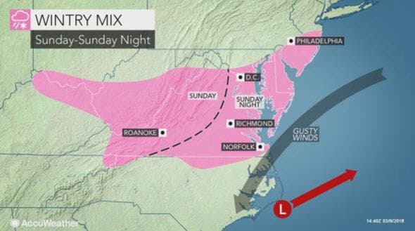
The first part of the storm will bring drenching rain, localized severe weather and travel disruptions to the southern United States this weekend, according to the release.
"At this time, we feel there is a better than 50/50 percent chance the worst of the storm will stay to the south and east of New York City," according to AccuWeather Senior Meteorologist Dave Dombek. "A light amount of snow [and rain] cannot be ruled out with roads mainly [expected to stay] wet."
A combination of rain and snow is likely in eastern Virginia, eastern Maryland, Delaware and southern New Jersey, according to the release.
This portion of the lower mid-Atlantic coast has potential for snow to fall at a heavy rate. How much, if any, snow accumulates in this area will depend on the strength of the storm and whether or not temperatures dip into the low to middle 30s F or spend most of the time in the 40s.
The storm is likely to strengthen quickly enough to produce gusty winds along part of of the mid-Atlantic coast, according to the release. The winds will push water toward the coast and result in flooding at times of high tide from northeastern North Carolina to southern New Jersey.
Here is the forecast:
- Saturday: Mostly sunny, with a high near 45. West wind 14 to 17 mph.
- Saturday night: Mostly clear, with a low around 23. West wind 6 to 8 mph.
- Sunday: Sunny, with a high near 48. Northwest wind 7 to 10 mph.
- Sunday night: A slight chance of snow after 1am. Mostly cloudy, with a low around 25. Light and variable wind becoming north 5 to 7 mph in the evening. Chance of precipitation is 20%.
- Monday: A chance of snow before 1pm, then rain likely between 1pm and 4pm, then snow likely after 4pm. Cloudy, with a high near 41. Northeast wind 7 to 9 mph. Chance of precipitation is 60%. New snow accumulation of less than a half inch possible.
- Monday night: Snow likely, mainly before 7pm, then a chance of snow showers after midnight. Mostly cloudy, with a low around 29. Chance of precipitation is 60%.
- Tuesday: A chance of snow showers before 11am, then a chance of rain showers. Mostly cloudy, with a high near 43. Chance of precipitation is 30%.
Mark Doyle photo
Get more local news delivered straight to your inbox. Sign up for free Patch newsletters and alerts.


