Weather
Snow Now In Thanksgiving Holiday Weekend Forecast For NJ
The most heavily traveled holiday weekend of the year is upon us, and it doesn't appear the weather will cooperate.


NEW JERSEY – The most heavily traveled holiday weekend of the year is upon us, and it doesn't appear the weather will cooperate.
Thanksgiving travel delays are likely through the weekend as "multiple storm systems" move across the country with rain, snow and wind, forecasters say. Read more: Best, Worst Times For Thanksgiving Travel In New Jersey
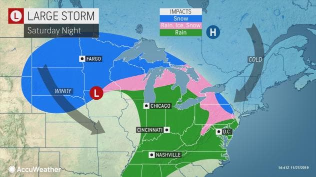
Snow is in the forecast for Saturday and Sunday in New Jersey, and a hazardous weather outlook has been issued for nearly the entire state. The National Weather Service says a storm system could bring wintry weather to the region beginning Saturday night and lasting into Monday.
Find out what's happening in Point Pleasantfor free with the latest updates from Patch.
But first, it's the wind that will be a problem Wednesday and Thursday. Windy conditions, with gusts in the mid-40 mph range, could cause airport delays, forecasters said.
Find out what's happening in Point Pleasantfor free with the latest updates from Patch.
A wind advisory is now in effect until 6 p.m. on Thanksgiving across the state.
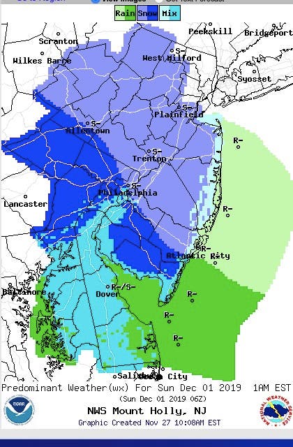
Then the chance for wintry weather increases Saturday night. Overnight and into Sunday morning, snow or a snow-and-rain mix is possible across New Jersey.
The coast-to-coast storm, already impacting the western United States, will deliver rain, ice and snow to the northeastern U.S. this weekend as many Americans make return trips after the holiday, according to AccuWeather.
The same "bomb cyclone" storm unleashing rain and snow across the West from Wednesday to Thursday, the Plains and Mississippi Valley on Friday, and much of the Midwest on Friday night into Saturday will also be the weather maker for the Northeast over the weekend, according to AccuWeather.
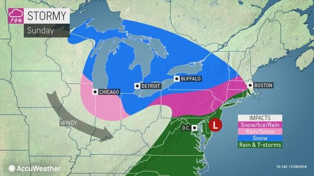
The wintry mix will then progress eastward Saturday night. A combination of rain, sleet and wet snow can reach all the way to the upper mid-Atlantic coast and central and southern New England by Sunday, according to AccuWeather.
Even if the storm manages to bring only rain to New York City and Philadelphia, the storm may have an entirely different and wintry character, according to AccuWeather. At the very least, rain will drench much of the I-95 corridor over the upper mid-Atlantic and southern New England areas on Sunday.
Exact details on the storm and the type of precipitation will be available in the coming days. Check back to Patch for updates.
Here is the forecast:
- Wednesday afternoon: A chance of rain before 1 p.m, then a chance of showers after 1 p.m. Mostly cloudy, with a high near 56. South wind 6 to 14 mph, with gusts as high as 24 mph. Chance of precipitation is 40 percent. New precipitation amounts of less than a tenth of an inch are possible.
- Wednesday night: A slight chance of showers before 8 p.m. Mostly cloudy, with a low around 40. Breezy, with a west wind 13 to 22 mph and gusts as high as 33 mph. Chance of precipitation is 20 percent.
- Thanksgiving Day: Mostly sunny, with a high near 50. Breezy, with a northwest wind 18 to 24 mph and gusts as high as 36 mph.
- Thursday night: Mostly clear, with a low around 29. Northwest wind 10 to 15 mph.
- Friday: Sunny, with a high near 45. North wind 9 to 11 mph.
- Friday night: Partly cloudy, with a low around 26.
- Saturday: Partly sunny, with a high near 42.
- Saturday night: A chance of snow after 1 a.m. Mostly cloudy, with a low around 29. Chance of precipitation is 40 percent.
- Sunday: Rain. High near 45. Chance of precipitation is 80 percent.
- Sunday night: Rain likely, mainly before 1 a.m. Cloudy, with a low around 35. Chance of precipitation is 60 percent.
- Monday: Mostly cloudy, with a high near 41.
Get more local news delivered straight to your inbox. Sign up for free Patch newsletters and alerts.