Weather
Stormy Weather For New Year's Eve In NJ: Here's What To Expect
And a chance of snow returns to New Jersey weather forecast. Here are the updated details.


If you have plans on New Year's Eve, please make sure you bring an umbrella with you. Or if you're heading into to a party or even New York City, maybe something more.
Heavy rain moves in Monday and New Jersey can expect downpours just before the ball drops to usher in 2019. Another inch or two of rain is expected but temps will be around 50 degrees before falling swiftly on New Year's Day.
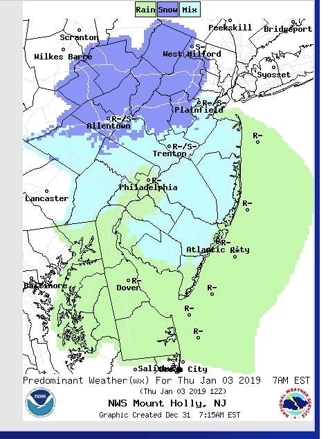
And for those of you who are curious when we may see snow again, it looks like there is a chance for some snow late Thursday and Friday. Of course, it may also be a mix of rain and snow, according to the National Weather Service.
Find out what's happening in Point Pleasantfor free with the latest updates from Patch.
A hazardous weather outlook has been issued for most of the state as moderate to locally heavy rain is possible from late Monday into the evening. Given the wet conditions across the region, localized flooding may occur in the areas where the heaviest rain falls.
-1546266845-193.jpg)
Rain will fall mainly before 4 a.m. after New Year's Eve and on New Year's Day, according to the National Weather Service. The rain could be heavy at times, and patchy fog is expected before midnight.
Find out what's happening in Point Pleasantfor free with the latest updates from Patch.
Winds also will hit 7 to 11 mph and could gust as high as 24 mph. Chance of precipitation is 100 percent. New precipitation amounts will be between three quarters and one inch possible.
Much of the weather will be dry until Thursday, when there will be a chance of snow in the morning and freezing rain in the evening and on Friday morning.
Here is the forecast:
- Monday: Rain, mainly after 3pm. Patchy fog after 4pm. High near 49. Calm wind becoming southeast 5 to 9 mph in the morning. Chance of precipitation is 90%. New precipitation amounts between a tenth and quarter of an inch possible.
- Monday night: Rain, mainly before 4am. The rain could be heavy at times. Patchy fog before midnight. Temperature rising to around 55 by 5am. Southeast wind 13 to 18 mph becoming southwest after midnight. Winds could gust as high as 28 mph. Chance of precipitation is 100%. New precipitation amounts between a half and three quarters of an inch possible.
- New Year's Day: Mostly sunny, with a high near 60. Breezy, with a west wind 16 to 21 mph, with gusts as high as 32 mph.
- Tuesday night: Partly cloudy, with a low around 32. Northwest wind 8 to 13 mph.
- Wednesday: Partly sunny, with a high near 40. Northwest wind 6 to 8 mph becoming northeast in the afternoon.
- Wednesday Night: Mostly cloudy, with a low around 31.
- Thursday: Chance of snow or rain in the morning. Mostly cloudy, with a high near 45.
- Thursday night: A chance of snow or rain after 1am. Mostly cloudy, with a low around 34. Chance of precipitation is 30%.
- Friday: A chance of smow or rain. Mostly cloudy, with a high near 47. Chance of precipitation is 40%.
- Friday night: A chance of rain. Mostly cloudy, with a low around 34. Chance of precipitation is 40%.
- SaturdayA chance of rain. Partly sunny, with a high near 47. Chance of precipitation is 30%.
Photo credit: Shutterstock
Get more local news delivered straight to your inbox. Sign up for free Patch newsletters and alerts.


