Weather
Thunderstorms In NJ This Week In Spooky Halloween Forecast
Severe weather could hit NJ this week – a possible Halloween "nightmare" for parents, commuters. One town offered to move trick-or-treating.


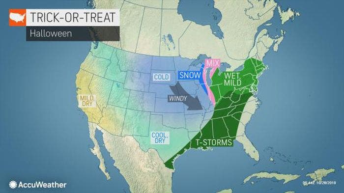
Halloween could become a nightmare for parents and commuters in New Jersey as several storms – including possible severe weather – are expected to impact the region through the week, forecasters say.
Thunderstorms are expected on Halloween, according to the National Weather Service. One New Jersey community – South Plainfield – even sent a letter to parents saying that trick-or-treating will be allowed on Saturday, and it's optional (see forecast below).
But expect rough weather before then, too. The National Weather Service has issued a hazardous weather outlook for most of the state, saying rain and thunderstorms will impact New Jersey off-and-on through Thursday.
Find out what's happening in Point Pleasantfor free with the latest updates from Patch.
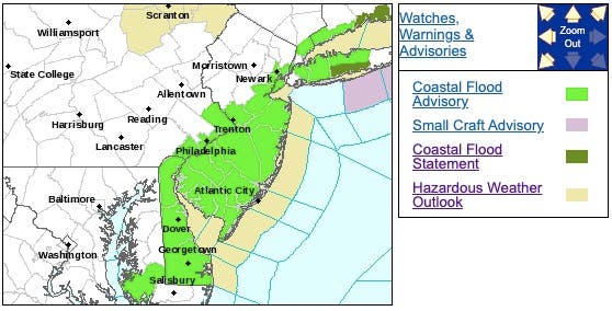
A coastal flood advisory is in effect in Central and South Jersey until 1 p.m. on Tuesday.
On Halloween, there's a chance of rain and thunderstorms during the late afternoon and early evening hours, then heavier rain and possibly a thunderstorm are expected to arrive after 8 p.m.
Find out what's happening in Point Pleasantfor free with the latest updates from Patch.
Some of the Halloween storms could produce heavy rainfall, and the chance of precipitation is 90 percent. New rainfall amounts between a quarter and half-of-an-inch are possible.
It won't be anything like the storms that forced former Gov. Chris Christie to cancel Halloween after Superstorm Sandy in 2012 – the seventh anniversary of which was on Monday. Then there was the 2011 Halloween nor'easter that caused trees and branches to fall and nearly compelled local officials to cancel the holiday then, too.
But it could certainly impact your plans.
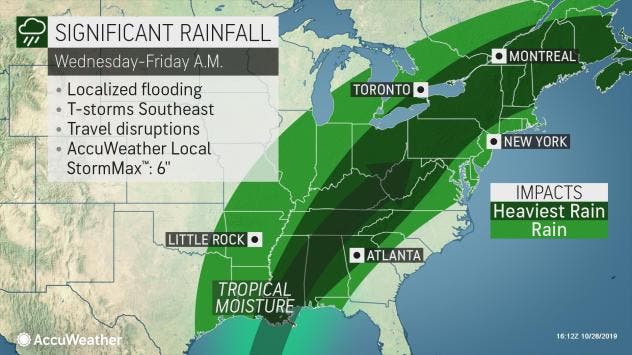
The weather is part of a large storm system sweeping eastward, according to The Weather Channel.
A low-pressure system is expected to develop in the mid-South early on Halloween before moving northeastward into Halloween night, according to The Weather Channel
Showers and thunderstorms could stretch from the central Gulf Coast to the Southeast, Ohio Valley, mid-Atlantic and Northeast on Thursday.
Here is the forecast:
- Tuesday: Patchy drizzle with a chance of light rain. Cloudy, with a high near 62. East wind around 7 mph. Chance of precipitation is 30 percent. New precipitation amounts of less than a tenth of an inch possible.
- Tuesday night: A chance of drizzle or light rain. Areas of fog after 11 p.m. Otherwise, cloudy, with a low around 54. Northeast wind around 5 mph becoming calm. Chance of precipitation is 30%. New precipitation amounts of less than a tenth of an inch possible.
- Wednesday: A chance of drizzle or light rain before 2pm, then a chance of showers after 2pm. Areas of fog before 2pm. Otherwise, cloudy, with a high near 68. North wind around 6 mph becoming light and variable in the afternoon. Chance of precipitation is 30 percent. New precipitation amounts of less than a tenth of an inch possible.
- Wednesday night: Showers likely, mainly after 8 p.m. Cloudy, with a low around 58. Calm wind becoming south around 5 mph after midnight. Chance of precipitation is 70 percent. New precipitation amounts of less than a tenth of an inch possible.
- Thursday: Rain likely, mainly before 2pm. Cloudy, with a high near 71. South wind 7 to 15 mph. Chance of precipitation is 70 percent. New precipitation amounts between a tenth and quarter of an inch possible.
- Thursday night: A chance of rain and thunderstorms, then rain and possibly a thunderstorm after 8 p.m. Some of the storms could produce heavy rainfall. Low around 54. Chance of precipitation is 90 percent. New rainfall amounts between a quarter and half of an inch possible.
Get more local news delivered straight to your inbox. Sign up for free Patch newsletters and alerts.