Weather
Timeline For Worst NJ Heat In 2019 As Index Hits 118 Degrees
UPDATE: All sorts of heat warnings are in effect for Saturday and Sunday since the heat index hit as high as 118. Find out where.


You may want to take that dip in the pool or in the ocean as soon as possible. New Jersey is experiencing some of the worst heat we've had all year, and the heat index has hit 118 in some areas of the Jersey Shore. And a major Monmouth County event was delayed because of it.
The National Weather Service has issued an excessive heat warning in most of the state since the heat index hit 112 in New Jersey on Friday. Read more: 116-Degree Heat Index Possible As NJ Weather About To Get Worse
More of the same is expected on Saturday and Sunday, and the heat index could hit higher than 118 on both days. The heat index, which combines the real temperature with the humidity level, hit 118 in Monmouth County.
Find out what's happening in Point Pleasantfor free with the latest updates from Patch.
The Haskell Invitational was delayed at Monmouth Park because of the heat. Racing is set to resume at 6 p.m.
See the forecast below. Here is where the heat index was at its worst at 3 p.m.:
Find out what's happening in Point Pleasantfor free with the latest updates from Patch.
.png)
Here is where the heat index was at its worst at 5 p.m.:
.png)
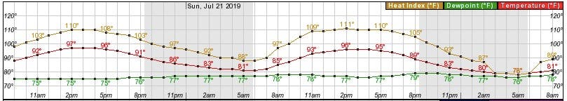
The excessive heat warning and heat advisory will remain in effect until 10 p.m. on Sunday. Here is when the heat index was supposed to hit its peak (the yellow line is heat index and the red is for actual temperature) at 2 p.m. on Saturday and Sunday in the Wildwood area:
Here is what to expect:
- HEAT INDEX VALUES...Up to 116 due to temperatures in the upper 90s, and dew points around 70.
- TIMING...The highest heat index values will occur from the late morning into the early evening.
- IMPACTS...The heat and humidity may cause heat stress during outdoor exertion or extended exposure. The heat may be life-threatening to the elderly and those in poor health because of prolonged exposure without air conditioning, especially those in urban centers where low temperatures in the middle and upper 70s offer little relief. The heat and humidity may cause heat stress during outdoor exertion or extended exposure.
- PRECAUTIONARY/PREPAREDNESS ACTIONS...Take extra precautions: If you work or spend time outside, reschedule strenuous activities to early morning or evening. Know the signs and symptoms of heat exhaustion and heat stroke. Wear light weight and loose fitting clothing when possible and drink plenty of water.
An excessive heat warning or heat advisory means that a prolonged period of dangerously hot temperatures will occur. The combination of hot temperatures and high humidity will combine to create a dangerous situation in which heat illnesses are likely, according to the National Weather Service.
Young children and pets should never be left unattended in vehicles under any circumstances. This is especially true during warm or hot weather when car interiors can reach lethal temperatures in a matter of minutes.
The added strain of dealing with days of heat and humidity can lead to higher energy costs and an increasingly greater threat of residents suffering heat-related illnesses, according to AccuWeather.
.png)
Here is the forecast:
- Saturday: Mostly sunny and hot, with a high near 99. Heat index values as high as 116. West wind 6 to 10 mph.
- Sunday night: Partly cloudy, with a low around 80. West wind 5 to 8 mph.
- Sunday: A slight chance of showers and thunderstorms after 2pm. Mostly sunny and hot, with a high near 99. Heat index values as high as 116. West wind 5 to 8 mph. Chance of precipitation is 20%.
- Sunday night: A chance of showers and thunderstorms, mainly after 8pm. Partly cloudy, with a low around 76. West wind around 6 mph becoming calm in the evening. Chance of precipitation is 50%. New rainfall amounts of less than a tenth of an inch, except higher amounts possible in thunderstorms.
- Monday: Showers and thunderstorms likely, then showers and possibly a thunderstorm after 2pm. High near 90. Calm wind becoming southwest around 6 mph in the afternoon. Chance of precipitation is 80%. New rainfall amounts between a half and three quarters of an inch possible.
- Monday night: Showers and possibly a thunderstorm before 8pm, then showers and thunderstorms likely between 8pm and 2am, then showers likely and possibly a thunderstorm after 2am. Low around 71. Chance of precipitation is 80%. New rainfall amounts between a half and three quarters of an inch possible.
Here is where the heat index was at its worst at 2:15 p.m.:
.png)
Here is where the heat index was at its worst at 1:30 p.m.:
.png)
Here is where the heat index was at its worst at 1:20 p.m.:
.png)
Here is where the heat index was at its worst at 12:20 p.m.:
.png)
Here is where the heat index was at its worst at 12 noon:
.png)
Here is where the heat index was at its worst at 11 a.m.:
.png)
Here is where the heat index was at its worst at 10 a.m.:
.png)
Get more local news delivered straight to your inbox. Sign up for free Patch newsletters and alerts.