Weather
Winter Weather Advisory In 7 New Jersey Counties
UPDATE: Predicted snow totals have increased. The winter weather could be particularly troublesome to drivers. Here's what to expect.


Expect a troublesome ride on the Garden State Parkway and the New Jersey Turnpike on Wednesday now that a winter weather advisory is in effect in seven New Jersey counties. A winter storm warning is in effect in Atlantic County, where 3 to 6 inches could fall.
The National Weather Service issued a winter weather advisory now that as many as three inches of snow could fall in Ocean, southeastern Burlington, Cape May, Gloucester, Camden, Cumberland and Salem counties.
The winter weather advisory is in effect until 6 p.m., but much of the snow is expected to fall between 3 and 6 p.m.
Find out what's happening in Point Pleasantfor free with the latest updates from Patch.
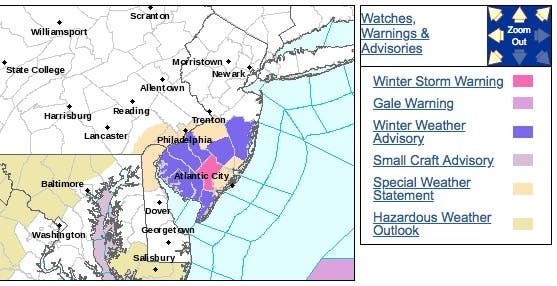
Here are the alerted areas:
Find out what's happening in Point Pleasantfor free with the latest updates from Patch.
The National Weather Service says the region should plan on slippery road conditions. The
hazardous conditions could impact the evening commute.
The area affected is expected to be a narrow band, so impacts and snow amounts could vary greatly over short distances. If driving within the advisory area, please exercise caution for
rapidly changing conditions.
In bands of heavier snow, visibilities could be reduced as well. Expect snow covered roads
and limited visibilities, and use caution while driving, the NWS says.
The New Jersey Department of Transportation announced that crews will begin brining operations along the interstate and state highways based on the various weather service forecasts provided to the department.
The department will begin pre-treating the roadways based on forecasts predicting moderate snow showers or light flurries on Wednesday. NJDOT will modify plans as the forecast develops.
Motorists are reminded to use caution when driving in winter weather and are encouraged to check NJDOT's traffic information website www.511nj.org for real-time travel information. For NJDOT news follow us on Twitter @NJDOT_info or on the NJDOT Facebook page.
-1544010823-351.jpg)
Here is the forecast in the impacted areas:
- Wednesday: A slight chance of snow showers before 11am, then a chance of rain and snow showers between 11am and 3pm, then a chance of snow showers after 3pm. Increasing clouds, with a high near 38. Northeast wind 5 to 9 mph. Chance of precipitation is 40%. Total daytime snow accumulation of 1 to 3 inches possible.
- Wednesday night: Cloudy during the early evening, then gradual clearing, with a low around 25. West wind around 8 mph.
- Thursday: Mostly sunny, with a high near 40. West wind 7 to 10 mph.
- Thursday night: Mostly cloudy, with a low around 28. Southwest wind 6 to 8 mph.
Shutterstock photo
Get more local news delivered straight to your inbox. Sign up for free Patch newsletters and alerts.


