Weather
Winter Weather, Possible Snow Emerges In NJ's Weather Forecast
No, it won't be 60 forever. Winter is supposed to return. Here's what is expected.


OK, don't put those long-sleeve pullovers away just yet. You may even have to retrieve the snow shovel.
February's long flirtation with spring could be coming to an end now that the National Weather Service expects winter weather to return to New Jersey over the next few days.
The NWS says there are two chances of winter weather arriving, saying snow, sleet or rain are possible in New Jersey on Sunday night, Monday morning and night and on Tuesday morning.
Find out what's happening in Point Pleasantfor free with the latest updates from Patch.
The weather could change school schedules on Monday and Tuesday. Read more: New Jersey School Closings/Delays List For Monday And Tuesday
Here is what is expected:
Find out what's happening in Point Pleasantfor free with the latest updates from Patch.
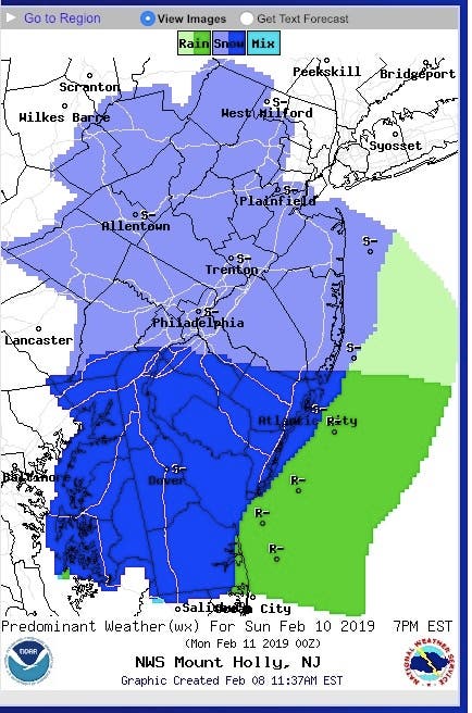
- Snow is expected to fall mainly in South Jersey on Sunday night, around 7 p.m., but the rest of the state could get some winter weather as well:
![]()
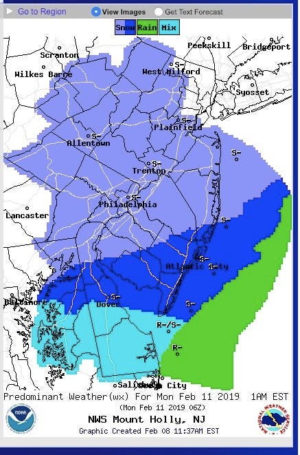
- More is expected to fall by Monday morning, and it could create a hazard for commuters. Schools could be impacted as well:
![]()
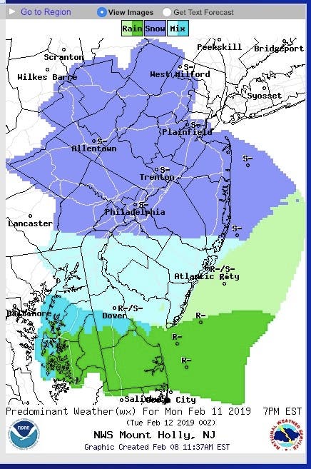
- The worst weather is expected to arrive on Monday night, coming in the form of a wintry mix around, 7 p.m.:
![]()
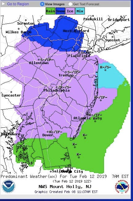
- That rough weather could continue to Tuesday morning and impact the commute. School could be impacted again:
![]()
AccuWeather also predicted that least two storms with some snow and ice will bring difficult travel and are likely to prompt school delays and closings in the span of a few days.
The first storm will be the weaker of the two but may be the snowiest for many locations. However, because of that, it is the less likely of the two to pull warm air up from the south very far, according to AccuWeather.
"Since the storm late this past week washed away much of the salt from the roads, crews may have to work extra hard reapplying ice melting compounds in this extensive area of snow forecast," AccuWeather Chief Meteorologist Elliot Abrams said in a release.
Just enough snow, a general 1-3 inches, may fall along the Interstate 70 and I-80 corridors to create slippery travel from the Plains to near the mid-Atlantic coast, according to AccuWeather.
-1549650191-1414.jpg)
The second storm of next week is forecast to be significantly stronger, more complex and may travel well to the north in the cold air with heavy precipitation, according to AccuWeather.
Ice may continue to glaze surfaces far south as western Virginia and central Maryland, but more likely across parts of central Pennsylvania, upstate New York and interior New England and, eventually, parts of New Jersey through the height of the storm, according to AccuWeather.
-1549650321-989.jpg)
Here is the forecast:
- Friday: Mostly sunny, with a high near 54. West wind around 18 mph, with gusts as high as 33 mph.
- Friday night: Mostly clear, with a low around 22. West wind 15 to 18 mph, with gusts as high as 31 mph.
- Saturday: Sunny, with a high near 34. Northwest wind 11 to 18 mph, with gusts as high as 31 mph.
- Saturday night: Clear, with a low around 16. Northwest wind 3 to 7 mph.
- Sunday: Mostly sunny, with a high near 36. Calm wind becoming southwest around 6 mph in the morning.
- Sunday night: A chance of snow. Mostly cloudy, with a low around 27. Chance of precipitation is 40%.
- Monday: Mostly cloudy, with a high near 40.
- Monday night: A chance of snow. Mostly cloudy, with a low around 26. Chance of precipitation is 30%.
- Tuesday: Snow and sleet likely before 10am, then rain and sleet likely between 10am and 1pm, then rain likely after 1pm. Cloudy, with a high near 38. Chance of precipitation is 70%.
- Tuesday night: Rain likely before 1am, then snow, freezing rain, and sleet likely. Cloudy, with a low around 30. Chance of precipitation is 60%.
Tom Davis photos
Get more local news delivered straight to your inbox. Sign up for free Patch newsletters and alerts.


