Weather
Princeton Prepares For Major Winter Storm: Latest Forecast, How To Prepare
From Saturday night through Monday morning, Princeton is expected to get between 12 to 18 inches of snow.

PRINCETON, NJ — As a major snowstorm heads toward Princeton, the Municipality is already making preparations.
A Winter Storm Warning has been issued for Princeton and is in effect from 7 p.m. Saturday through 1 p.m. Monday.
Travel may become very difficult to impossible, especially during peak storm periods. Hazardous road conditions are expected and may significantly affect the Monday morning commute.
Find out what's happening in Princetonfor free with the latest updates from Patch.
Preparations
- Avoid unnecessary travel if possible
- If you must travel, keep an emergency kit in your vehicle (flashlight, food, water, blankets)
- Check on neighbors, especially seniors and those with limited mobility
Parking & Snow Removal Requirements
Find out what's happening in Princetonfor free with the latest updates from Patch.
- All vehicles must be removed from municipal roadways so DPW can plow effectively
- Sidewalks must be cleared of snow and ice within 24 hours after the snowfall ends
PSE&G also offered some tips to prepare for the storm:
- If you (or a member of your household) rely on electricity to operate life-sustaining equipment, visit pseg.com/Life or call 1-800-436-PSEG (7734) to let us know
- If you haven’t changed the batteries in your carbon monoxide detector lately, now is a good time to do so
- Know where your gas meter and regulator are located outside your home and be sure to keep them clear of snow and ice
- Download our PSEG mobile app, where you can report and track outages, by visiting pseg.com/App
Latest Forecast
From Saturday night through Monday morning, the National Weather Service is predicting that Princeton is expected to get between 12 to 18 inches of snow.

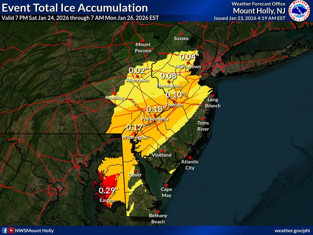
A possibility of about an inch of ice is also expected in Princeton.
Here is a timeline of the upcoming snowstorm:
Saturday Night: Snow likely after 1 a.m. Cloudy, with a low around 12. Calm wind becoming northeast around 5 mph. Chance of precipitation is 70 percent. New snow accumulation of less than one inch possible.
Sunday: Snow before 4 p.m, then snow, freezing rain, and sleet. The snow could be heavy at times. High near 26. Northeast wind 5 to 15 mph, with gusts as high as 25 mph. Chance of precipitation is 100 percent. Little or no ice accumulation expected. New snow and sleet accumulation of 7 to 11 inches possible.
Sunday Night: Snow, freezing rain, and sleet before 1 a.m., then freezing rain and sleet likely between 1 and 4 a.m., then snow likely after 4 a.m. Low around 20. Chance of precipitation is 100 percent. New precipitation amounts between a half and three-quarters of an inch possible.
Monday: Snow likely, mainly before 7 a.m. Mostly cloudy, with a high near 28. Chance of precipitation is 60 percent.
Have a news tip? Email alexis.tarrazi@patch.com.
Get more local news delivered straight to your inbox. Sign up for free Patch newsletters and alerts.