Crime & Safety
Major Storm Expected For New Jersey; Hazardous Weather Outlook Issued
What's being described as a "major storm" is heading toward New Jersey, and a hazardous weather outlook has been issued.


Just days ago, the forecasters said that next week will look like April. Now it could look more like hurricane season.
What's being described as a "major storm" that could bring tropical storm-force winds is heading toward New Jersey, and the National Weather Service has issued a hazardous weather outlook for the entire state on Sunday and Monday.
There should little to no snow, because temperatures will be in the high 30s and 40s. But it won't matter: Heavy rain, windy conditions and coastal flooding are all possible for Sunday afternoon through Monday night.
Find out what's happening in Toms Riverfor free with the latest updates from Patch.
The storm could develop into a nor'easter, bringing drenching rain and gusty winds as it sweeps eastward from California to Georgia and Florida this weekend, according to a release from AccuWeather, which described the system as a "major storm."
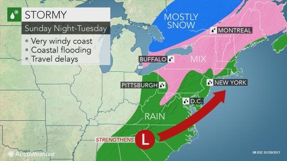
"Enough rain will fall to cause street and poor drainage-area flooding," AccuWeather Senior Meteorologist John Gresiak said in the release.
Find out what's happening in Toms Riverfor free with the latest updates from Patch.
If the storm develops to its full potential, winds could become strong enough to down trees and cause sporadic power outages, according to AccuWeather.
Indeed, the potential conditions concerned the National Weather Service enough that the agency issued a "briefing package," which it normally does for heavy snowstorms, tropical storms and hurricanes:
- Hazards: Strong Winds – Northeast winds 20 to 35 mph with gusts to 45 mph are possible from Sunday evening through Monday evening, with the strongest winds near the coast.
- Heavy rainfall – There is potential for periods of heavy rainfall from Sunday afternoon through Monday night, with 1 to 3 inches possible across the area.
- Due to the uncertainty in the location of the heaviest rain, it is too early to determine whether river or urban flooding will be a concern. Confidence is moderate in the occurrence of heavy rain but low for where the heaviest rain will fall and the degree of potential flooding.
- Wintry Precipitation – Currently, it looks like temperatures will be warm enough for all rain - and no snow - to fall throughout the storm, except for Carbon and Monroe counties in Pennsylvania and Sussex County in New Jersey. In these areas, there could be some freezing rain Sunday night and a wintry mix Monday night.
- Coastal Flooding – Minor flooding is probable, especially along the ocean. The extent of the coastal flooding will be dependent on the track and strength of the storm. If the storm is stronger and slower then moderate tidal flooding would be possible, especially along the ocean and back bays.

Here is the forecast for the area:
- Friday: Rain, mainly after noon. High near 48. Calm wind becoming south around 6 mph in the afternoon. Chance of precipitation is 100 percent. New precipitation amounts between a tenth and quarter of an inch possible.
- Friday night: A chance of rain, mainly before 7pm. Patchy fog. Otherwise, cloudy, with a low around 40. South wind 3 to 5 mph. Chance of precipitation is 30 percent. New precipitation amounts of less than a tenth of an inch possible.
- Saturday: Areas of fog before 9am. Otherwise, mostly cloudy, with a high near 56. Calm wind becoming west around 6 mph in the morning.
- Saturday night: Mostly cloudy, with a low around 42. Calm wind.
- Sunday: Rain likely, mainly after noon. Cloudy, with a high near 53. Light east wind increasing to 10 to 15 mph in the morning. Chance of precipitation is 70 percent. New precipitation amounts between a 10th and quarter of an inch possible.
- Sunday night: Rain likely. Cloudy, with a low around 38. Windy. Chance of precipitation is 70%. New precipitation amounts between a half and three quarters of an inch possible.
- Monday: Rain. High near 45. Windy. Chance of precipitation is 80 percent.
- Monday night: Rain likely. Cloudy, with a low around 37. Windy. Chance of precipitation is 70 percent.
- Tuesday: A chance of rain before 1pm. Cloudy, with a high near 45. Chance of precipitation is 50 percent.
Patch file photo
Get more local news delivered straight to your inbox. Sign up for free Patch newsletters and alerts.