Neighbor News
NY NJ PA Weather: Heavy Rain Today, Flash Flooding Possible
Thunderstorms are expected as low pressure system moves through


By Steven DiMartino, NY NJ PA Weather Blog
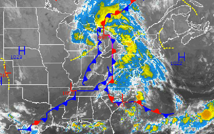
An area of low pressure and an occluded cold front will drive through the Philadelphia and New York City metropolitan areas Tuesday on through early Wednesday morning, leading to very heavy rainfall throughout the region. Flash flooding is expected from this heavy rainfall. High pressure takes hold for the rest of the week and this weekend with excellent weather conditions, though!
Tuesday through Wednesday morning, waves of moderate to heavy rainfall with embedded thunderstorms can be expected. Rainfall rates will exceed an inch per hour at times leading to visibility below 2 miles at times and flash flooding of rivers, streams, and some roadways. Thunderstorms will feature very heavy downpours, occasional to frequent lightning, and wind gusts over 40 mph. Rainfall amounts will range from 1 to 3 inches with local amounts up to 5 inches in heavy downpours. The rain will come in waves through Wednesday morning and then exit from west to east late morning on through Wednesday afternoon with clearing skies. Winds will be from the southeast at 10 to 20 mph through Tuesdday and veer to the northwest at 10 to 20 mph by Wednesday afternoon. Temperatures will rise into the mid- to upper 70s for highs this afternoon. Temperatures Wednesday will range from the upper 60s to lower 70s for lows and upper 70s to lower 80s for highs.
Find out what's happening in Toms Riverfor free with the latest updates from Patch.
Canadian high pressure will be in place by tomorrow night with clearing skies. Scattered cloud cover to clear skies can be expected Thursday on through Sunday. A very comfortable and cool air mass will be in place through Saturday. Low temperatures will range from the lower to mid-50s over the interior and mid- to upper 50s along the coast. High temperatures will range from the upper 70s to lower 80s throughout the region. On Sunday and Monday, temperatures will return to near normal levels with lows in the lower to mid-60s and highs in the lower to mid 80s.
Get more local news delivered straight to your inbox. Sign up for free Patch newsletters and alerts.