Weather
Severe Thunderstorm Watch In 7 NJ Counties
UPDATED: New Jersey has had its share of severe weather lately, and more is expected.


New Jersey has already had its share of severe weather lately – including two tornadoes last week. The National Weather Service has now issued a severe thunderstorm watch for seven New Jersey counties.
The severe thunderstorm watch, which expires at 11 p.m., was issued for Burlington, Atlantic, Cape May, Camden, Gloucester, Cumberland and Salem counties.
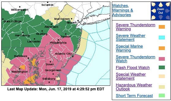
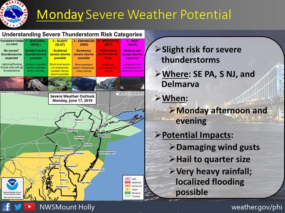
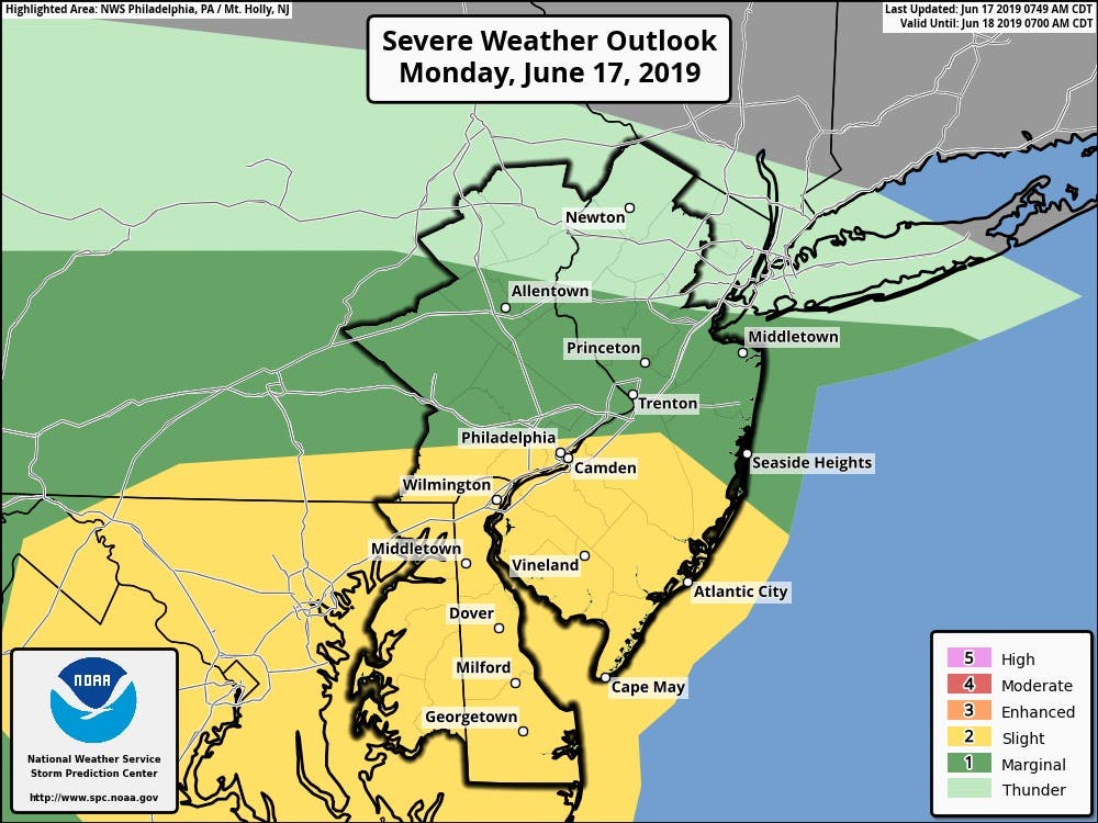
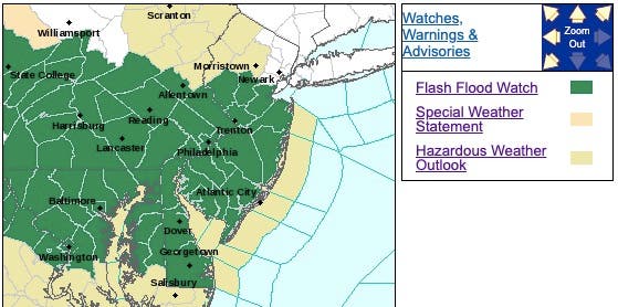
The National Weather Service already had issued hazardous weather outlook for nearly the entire state, saying there's a chance of severe storms on Monday evening in New Jersey, with the main risk being damaging winds.
Find out what's happening in Toms Riverfor free with the latest updates from Patch.
Indeed, bad weather is expected throughout the week (see forecast below).
On Monday, most of the storms are supposed to happen after 7 p.m. Here are the areas that will be most directly affected:
Find out what's happening in Toms Riverfor free with the latest updates from Patch.
The alerts come after two tornadoes hit New Jersey in just the last four days. Read more: 2 Tornadoes ID'd In NJ This Week As More Bad Weather Possible
The NWS also has issued a flash flood watch for most of the state, saying strong thunderstorms are expected to develop and move through New Jersey on Monday afternoon and evening.
The environment will be favorable for torrential rainfall with these storms, according to the NWS. Additionally, storms may begin to track over the same locations as a very slow-moving front allows for the redevelopment of bad weather.
There is potential for one to three inches of rain in a very short period of time where the strongest storms occur. Here are the affected areas:
AccuWeather also says that thunderstorms will pulse and become locally severe from the central Appalachians to the mid-Atlantic coast on Monday.
The storms will mostly rumble in parts of West Virginia, southern Pennsylvania, Maryland, Delaware, southern New Jersey and northern and central Virginia, according to AccuWeather. Lightning poses the most widespread risk to people and pets outdoors.
A few of the strongest thunderstorms can produce a tornado, according to AccuWeather. While the tornado risk is low for any one location, the chance of such a storm is greatest from the mid-afternoon to the early-evening hours. In some cases, the tornado may be wrapped in rain and difficult to spot.
A small number of locations may be hit with pea- to golf ball-sized hail as well, according to AccuWeather. On Tuesday, the risk of locally severe thunderstorms will shift a bit farther to the south.
The threat for severe storms will extend from central and eastern parts of Kentucky and Tennessee to much of West Virginia, Virginia, Maryland and Delaware, and then to the southern tip of New Jersey on Tuesday, according to AccuWeather.
.jpeg)
- Monday: A chance of showers, with thunderstorms also possible after 5pm. Some of the storms could be severe. Mostly cloudy, with a high near 81. Calm wind becoming south around 5 mph in the afternoon. Chance of precipitation is 40%. New rainfall amounts between a tenth and quarter of an inch, except higher amounts possible in thunderstorms.
- Monday night: Showers and thunderstorms before 5am, then a chance of showers. Some storms could be severe, with damaging winds and heavy rain. Low around 66. Southeast wind around 6 mph. Chance of precipitation is 80%. New rainfall amounts between a quarter and half of an inch possible.
- Tuesday: A chance of showers, then showers likely and possibly a thunderstorm after 8am. Mostly cloudy, with a high near 82. Calm wind becoming west around 5 mph in the afternoon. Chance of precipitation is 60%. New rainfall amounts between a quarter and half of an inch possible.
- Tuesday night: Showers likely and possibly a thunderstorm. Mostly cloudy, with a low around 65. Light southwest wind. Chance of precipitation is 60%. New rainfall amounts between a quarter and half of an inch possible.
- Wednesday: A chance of showers, then showers likely and possibly a thunderstorm after 2pm. Mostly cloudy, with a high near 79. Calm wind becoming east around 5 mph in the afternoon. Chance of precipitation is 60%. New rainfall amounts between a tenth and quarter of an inch, except higher amounts possible in thunderstorms.
- Wednesday night: Showers likely and possibly a thunderstorm before 8pm, then a chance of showers and thunderstorms between 8pm and 2am, then a chance of showers after 2am. Mostly cloudy, with a low around 66. Chance of precipitation is 60%. New rainfall amounts between a tenth and quarter of an inch, except higher amounts possible in thunderstorms.
- Thursday: Showers likely, with thunderstorms also possible after 2pm. Mostly cloudy, with a high near 82. Chance of precipitation is 60%.
- Thursday night: Showers likely and possibly a thunderstorm. Mostly cloudy, with a low around 66. Chance of precipitation is 60%.
Get more local news delivered straight to your inbox. Sign up for free Patch newsletters and alerts.


