Weather
Tropical Storm Hermine On Track To 'Blast' New Jersey, Forecasters Say
The latest information has been released on Hermine, which is on track to impact N.J. A tropical storm watch was extended to more counties.


Tropical Storm Hermine remains on track to "blast" coastal areas of New Jersey with rough surf, heavy rain and gusty winds during Labor Day weekend and impact other areas of the state, forecasters say.
The rest of the state will also feel the storm's impact, getting 39 mph wind gusts and rain, according to the National Weather Service.
Find out what's happening in Toms Riverfor free with the latest updates from Patch.
Mostly, Hermine threatens to foil weekend getaways at the beach and has the potential to cause damage in some communities and pose risk to the lives of those who venture in the surf or on the seas, according to AccuWeather.
A tropical storm watch is in effect for Monmouth, Ocean, eastern Burlington, Atlantic and Cape May counties. Around 11 a.m. on Friday, that watch was extended to Middlesex and Hudson counties.
Find out what's happening in Toms Riverfor free with the latest updates from Patch.
A hazardous weather outlook is in effect for the rest of New Jersey, since Hermine could produce heavy rain and gusty winds further inland as well. A tropical storm warning is in effect over the Atlantic Ocean, off the Jersey Shore.
According to AccuWearther:
AccuWeather reports after slamming Florida, Hermine will blast coastal areas of the mid-Atlantic with rough surf, heavy rain and gusty winds during Labor Day weekend.
The latest briefing on the storm from the National Weather Service says:
- Hermine made landfall in Florida and is weakening. It has been downgraded to a tropical storm.
- There is a slight eastward movement of the track but not much change overall. There remains quite a bit of uncertainty with the track.
- Rainfall amounts have increased for southern and eastern areas, especially the Delmarva and southeastern New Jersey. These areas could now see 4 to 6 inches of rain from Hermine.
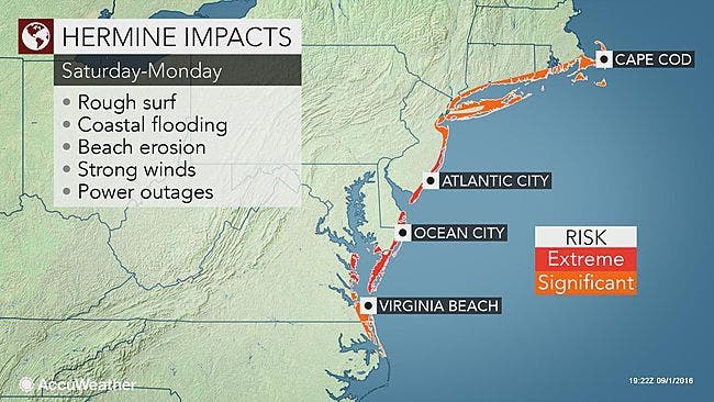
- Hazards: Rip Currents: High Confidence. A moderate to high risk for the formation of dangerous rip currents will continue through at least Labor Day, and may continue into Tuesday. Beachgoers should only enter the water if life guards are present. Most rip current deaths occur on beaches when and where no life guards are on duty. Beach erosion and high surf are also possible.
- Tidal Flooding: High Confidence. Minor tidal flooding is likely beginning with the Saturday evening high tide cycle and continuing through the Sunday night high tide cycle, possibly continuing into Monday or Tuesday. Moderate tidal flooding is possible with the Sunday high tide cycles.
- Given multiple rounds of tidal flooding, water in the back bays will have a hard time draining between tidal cycles which could lead to prolonged flooding in these locations. Major tidal flooding could occur along some of the back bays. Additionally, there could be tidal flooding into the upper portions of Delaware Bay and the tidal Delaware River.
- Strong Wind: Moderate confidence. There is a chance of tropical storm force wind (sustained wind of 39 mph or greater) for much of the region. The highest chance is along the Delaware Beaches and the southern New Jersey Shore Sunday into Sunday night. Even with an off shore track, gusts of 30 to 35 mph are expected along the coast.
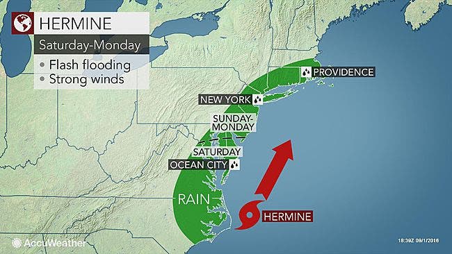
- Heavy rain: Moderate Confidence. There is expected to be a sharp cutoff in the heavy rain dependent on the track of Hermine . At this point, the highest risk of heavy rain in the Delmarva and south Jersey. The heaviest rain will fall from Saturday through Sunday, The primary flooding hazard will be street and flash flooding. The recent dry weather will lessen but not eliminate the risk of river and stream flooding.
A large mass of dry air will give way enough to allow Hermine to push up the Eastern Seaboard, beyond the southern United States this weekend, according to an AccuWeather news release.
A swath of heavy rain and gusty winds will advance northeastward over parts of Virginia, Maryland, Pennsylvania and New York as well as much of Delaware and New Jersey during Saturday and Saturday night. A push of rain and wind into southern New England may follow later in the weekend.
"Gusts between 60 and 75 mph are possible from Long Island, New York, to coastal New Jersey, and the southern tip of Delmarva," AccuWeather Senior Meteorologist Dave Dombek said in the release.
Enough rain and wind can occur along this swath to cause flash flooding, downed tree limbs and sporadic power outages.
"With a storm of this nature, flooding rainfall can occur, regardless of prior dryness," said AccuWeather Chief Meteorologist Elliot Abrams.
Hermine is likely to stall near the mid-Atlantic and southern New England coasts, causing adverse conditions for days regardless of its official classification of a tropical or non-tropical storm.
While the storm may lose tropical characteristics in mid-Atlantic waters, it could strengthen and act like a slow-moving, powerful nor'easter.
The stormy onslaught will occur during Sunday, Labor Day and perhaps into the middle of next week.
Here is the local forecast:
- Friday: Sunny, with a high near 80. North wind 8 to 11 mph.
- Friday night: Partly cloudy, with a low around 60. Northeast wind 3 to 6 mph.
- Saturday: A chance of rain after 1pm. Partly sunny, with a high near 77. East wind 7 to 12 mph increasing to 13 to 18 mph in the afternoon. Chance of precipitation is 30 percent. New precipitation amounts of less than a tenth of an inch possible.
- Saturday night: A chance of rain. Cloudy, with a low around 59. Northeast wind around 18 mph. Chance of precipitation is 40 percent. New precipitation amounts between a half and three quarters of an inch possible.
- Sunday: A chance of rain. Cloudy, with a high near 75. Windy, with a northeast wind 22 to 26 mph. Chance of precipitation is 50 percent. New precipitation amounts between a half and three quarters of an inch possible.
- Sunday night: Tropical storm conditions possible. A chance of rain. Cloudy, with a low around 63. Chance of precipitation is 50 percent. New precipitation amounts between a quarter and half of an inch possible.
- Labor Day: Tropical storm conditions possible. A chance of rain. Mostly cloudy, with a high near 80. Chance of precipitation is 30 percent.
- Monday night: Tropical storm conditions possible. Mostly cloudy, with a low around 64.
- Tuesday: Tropical storm conditions possible. Partly sunny, with a high near 85.
How close to the coast Hermine tracks and then stalls from Sunday onward will determine the severity and location of flooding and damaging winds. Even a small shift in the track can have a big difference on impacts.
"A track over land or right along the coast could translate to more of a heavy rain event, while a track just offshore could mean more of a wind hazard for the mid-Atlantic," Abrams said.
In addition to the risk of flooding from heavy rainfall, days of winds pushing Atlantic Ocean water toward the coast will cause extensive beach erosion, overwash in beachfront areas and flooding in low-lying locations on the back bays from Virginia to New York state.
This includes locations such as Virginia Beach, Virginia; Ocean City, Maryland; Atlantic City; and Rockaway, New York.
It is possible that some low-lying roads to coastal areas and the barrier islands may be blocked by high water. People may not be able to get to and from these locations for a time.
Dune repairs following Sandy may be tested because of the long duration of this event.
The risk of coastal flooding will be greatest around the times of high tide.
Conditions are likely to become too rainy to spend time on the mid-Atlantic beaches beyond Saturday, and surf conditions will become dangerous with strong and frequent rip currents and large, pounding waves as the weekend progresses.
"Offshore, seas are likely to become too dangerous for small craft and large vessels should use caution due to a fully arisen sea," Abrams said.
To venture into the surf or on the ocean during these conditions may not only put you at risk but also your would-be rescuers. Bathers and boaters should heed all official restrictions as they are issued.
Seas and surf are already rough in some locations of the mid-Atlantic and New England. This is due to other storms in progress over the Atlantic Ocean.
Photos: AccuWeather
Get more local news delivered straight to your inbox. Sign up for free Patch newsletters and alerts.