Crime & Safety
UPDATE: Nor'easter: Strong Winds, Outages, Snow And Rain Begin At Morning Rush
Snow, rain should begin prior to sunrise on Wednesday in New Jersey. Roads will be wet for morning rush. William Paterson University closed.

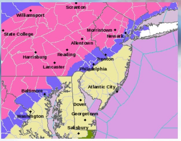

NWS Picture: Pink shading indicates areas where the strongest storm impacts are expected. Purple-shaded areas are where the storm impacts will be less severe.
Slick roads, strong wind gusts and power outages could be part of a developing coastal storm that will bring a wide variety of weather to New Jersey beginning early Wednesday morning, and lasting until the evening.
Areas to the north and west of Ocean County will have winter weather conditions, while the Jersey Shore is expected to have little to no snow accumulation. Up to 8 inches of snow could impact portions of the I-95 corridor and North Jersey.
Find out what's happening in Waynefor free with the latest updates from Patch.
Wet, heavy snow is expected in the northern and western areas of the state, according to a National Weather Service briefing package, with heavy rain in the south.
Hopatcong schools already announced they will be closed Wednesday in preparation for the pending nor’easter. William Paterson University in Wayne also announced that it will close on Wednesday.
Find out what's happening in Waynefor free with the latest updates from Patch.
In Westfield and other communities, local officials were advising people to remove their cars from the roads so snow plows could get through.
“Gusty winds everywhere. Land and air travel will be negatively impacted Wednesday and Wednesday night just before a major holiday. Power outages are likely with the combination of gusty winds and snow hanging on wires and tree limbs,” according to the National Weather Service.
Based upon current weather forecasts, the following weather conditions are expected as New Jersey approaches the Thanksgiving holiday, according to local police and the National Weather Service:
- The snow and rain should begin prior to sunrise on Wednesday morning. Roads will be wet for the morning rush.
- No coastal flooding is anticipated from this storm.
- After sunset Wednesday, rain in the Jersey Shore could mix with snow prior to all precipitation ending around midnight. Little or no snow accumulation is forecasted except in the extreme western parts of Ocean and Monmouth counties.
The National Weather Service has placed a winter storm watch in effect from 7 a.m. Wednesday to 7 a.m. Thursday, as the coastal storm moves its way into New Jersey and Pennsylvania.
NBC News said a nor’easter will impact much of the East Coast from Boston to Washington D.C. NJ101.5 offered this prediction:
- 8+ inches in far North Jersey
- 4-8 inches above and along I-78
- 2 to 4 inches above and along I-195
- 1-2 inches in South Jersey.
- Mostly rain with a coating to an inch of snow along the immediate coast.
Airline bound travelers could also face long delays and cancelled flights along the storm’s path. Travelers scheduled to fly out of town are advised to check the status of their flight before attempting to leave home.
In Barnegat and Waretown, officials said they are fully prepared for the storm and will immediately respond to any winter weather road conditions if needed.
“At this time, there is a chance for some snow-covered road surfaces mainly in the extreme western portion of both townships late Wednesday night into Thursday morning,” according to a Barnegat Township alert message.
More nor’easter coverage:
- Nor’easter: Strong Winds, Outages, Snow And Rain Begin At Morning Rush
- AAA Offers Winter Driving Tips as Winter Storm Approaches
- Nor’easter Threat Closes William Paterson University In Wayne
- Check for other school closings here
- Road Crew Ready for Nor’easter Bringing Up To 9 Inches of Snow to Long Valley
- ADVISORY: Winter Storm Warning In Effect For Westfield, Parking Restrictions Enforced
- Nor’easter Now Expected For New Jersey On Thanksgiving Eve
- Coastal Storm Still Expected To Hit New Jersey Wednesday, Thanksgiving
Get more local news delivered straight to your inbox. Sign up for free Patch newsletters and alerts.