Weather
HV Weather: 2018 Hurricane Season Could Be Nearly As Bad As 2017
Last year, there were 17 named storms and 10 hurricanes. Are you ready for severe weather?


Two recently released reports say the Hudson Valley could get a storm season that's nearly as bad — or just as bad — as last year. That's important to remember because hurricane season begins June 1 and lasts through Nov. 30.
The leading agency that predicts hurricanes wants people to know that the 2018 season could be nearly as bad as 2017, when Hurricanes Harvey, Irma and Maria devastated the Atlantic and Gulf coasts. And the season could have an impact on the Hudson Valley.
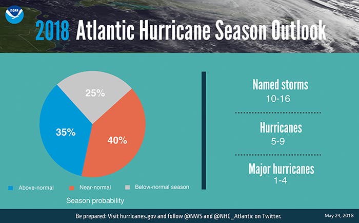
The National Oceanic and Atmospheric Administration is saying the season will have 10 to 16 named tropical storms, and the number of hurricanes could range between five and nine. One to four of the hurricanes are expected to reach major hurricane status, which means category three or higher.
Find out what's happening in Bedford-Katonahfor free with the latest updates from Patch.
SEE ALSO: Storm Alberto: How Will It Affect The Hudson Valley
Last year, 17 named storms and 10 hurricanes — six of them major — hit what's known as the Atlantic Basin, results that were above the 30-year average of 12 storms, six hurricanes and two major hurricanes.
Find out what's happening in Bedford-Katonahfor free with the latest updates from Patch.
The Atlantic and Gulf coasts had among the top 10 most active Atlantic seasons on record, Phil Klotzbach, tropical scientist at Colorado State University, told The Weather Channel.
This summer, the Hudson Valley is in for a "bit of everything" as the weather transitions between hot, humid and severe weather, according to AccuWeather.com.
A few hot periods will take hold throughout the summer, though it won't be persistent. "I think there's going to be surge later in June when we really start to feel some heat here in the Northeast. But will it stick around the whole summer? I don't think that's going to happen," AccuWeather.com Expert Long-Range Forecaster Paul Pastelok said in a release.
Severe weather could strike the region in June, according to AccuWeather. In July, that risk will shift farther northward.
-1527519763-4100.jpg)
NOAA said it has made advances made in hardware and computing over the course of the last year, improving the ability of forecasters to both predict the path of storms and warn Americans who may find themselves in harm’s way.
“The devastating hurricane season of 2017 demonstrated the necessity for prompt and accurate hurricane forecasts," said Secretary of Commerce Wilbur Ross.
The possibility of a weak El Nino developing, along with near-average sea surface temperatures across the tropical Atlantic Ocean and Caribbean Sea, are two of the factors driving this outlook. These factors are set upon a backdrop of atmospheric and oceanic conditions that are conducive to hurricane development and have been producing stronger Atlantic hurricane seasons since 1995, according to NOAA.
“NOAA’s observational and modeling enhancements for the 2018 season put us on the path to deliver the world’s best regional and global weather models,” said Neil Jacobs, Ph.D., assistant secretary of commerce for environmental observation and prediction. “These upgrades are key to improving hurricane track and intensity forecasts, allowing NOAA to deliver the best science and service to the nation.”
Written by Tom Davis, Patch National Staff.
YouTube photo/video.
Get more local news delivered straight to your inbox. Sign up for free Patch newsletters and alerts.