Community Corner
Snow Event: Weekend Storm Could Drop Significant Accumulations on Bedford, Katonah
The snow is forecast to hit before the middle of the afternoon on Saturday.

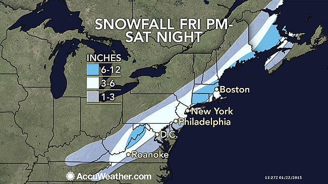
This weekend’s storm could dump up to six inches of snow throughout parts of the Hudson Valley, according to AccuWeather.com and the National Weather Service.
Considered to be the first major snow event of the season, the storm is expected to track along the I-95 corridor from south of Philadelphia through New England, and if rain does not mix in, it could leave a lot of the white stuff in its wake.
“Unlike many storms this winter, this particular one has the potential to bring a foot of snow to some locations, where rain fails to mix in over New England,” according to AccuWeather.com Chief Meteorologist Elliot Abrams.
Find out what's happening in Bedford-Katonahfor free with the latest updates from Patch.
In Westchester County, that rain, freezing at times, is expected, but snow accumulations could still reach four inches.
“Accumulating snow is most likely to fall from the mountains of western North Carolina, eastern Kentucky and western Virginia to southern and eastern Pennsylvania, northern New Jersey, the lower Hudson Valley of New York state and southeastern and central New England,” according to AccuWeather.com. “Enough snow is likely to fall to shovel and plow in this area.”
Find out what's happening in Bedford-Katonahfor free with the latest updates from Patch.
The snow is forecast to hit before the middle of the afternoon on Saturday, and highs could reach the low- to mid-30s throughout the region. The precipitation could then turn to freezing rain into the evening.
Image via AccuWeather.com
Subscribe to a free email newsletter and news alerts:
BEDFORD-KATONAH • BRONXVILLE-EASTCHESTER-TUCKAHOE • CHAPPAQUA-MOUNT KISCO • HARRISON • LARCHMONT-MAMARONECK • NANUET • NEW CITY • NEW ROCHELLE • NYACK-PIERMONT • OSSINING-CROTON • PEARL RIVER • PEEKSKILL-CORTLANDT • PELHAM • PORT CHESTER • PLEASANTVILLE-BRIARCLIFF • RIVERTOWNS • RYE • SCARSDALE • SOUTHEST-BREWSTER • TARRYTOWN-SLEEPY HOLLOW • WHITE PLAINS • YORKTOWN-SOMERS
Get more local news delivered straight to your inbox. Sign up for free Patch newsletters and alerts.