Community Corner
Severe Thunderstorm Watch in Effect For Nassau County
Gusty winds, heavy downpours and small hail possible. An isolated tornado is "not out of the question."

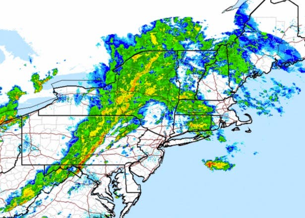
The National Weather Service has issued a severe thunderstorm watch for Nassau County.
The watch, which also applies to all of New York City, went into effect at 3:10 p.m. and will expire at 10 p.m.
The NWS says:
- THERE IS A POTENTIAL FOR STRONG TO SEVERE THUNDERSTORMS AND FLASH FLOODING TODAY...MAINLY IN THE AFTERNOON AND EVENING. SHOWERS AND THUNDERSTORMS COULD PRODUCE HEAVY RAIN WITH MAXIMUM HOURLY RAINFALL RATES APPROACHING 1 INCH PER HOUR. IF THESE HEAVIER SHOWERS AND THUNDERSTORMS MOVE OVER THE SAME LOCATIONS... FLASH FLOODING OF URBAN...LOW LYING...AND POOR DRAINAGE AREAS WOULD BE POSSIBLE. A FEW THUNDERSTORMS COULD ALSO BECOME SEVERE...WITH DAMAGING WIND GUSTS OF AT LEAST 58 MPH.
An isolated tornado is "not out of the question," the NWS says.
A severe thunderstorm by definition is a thunderstorm that produces one inch hail or larger in diameter and/or winds equal or exceed 58 miles an hour. During a severe thunderstorm watch, residents should review severe thunderstorm safety rules and be prepared to move a place of safety if threatening weather approaches, the NWS says.
The full forecast:
This Afternoon: Showers and thunderstorms. Some of the storms could produce heavy rainfall. High near 72. South wind around 13 mph. Chance of precipitation is 80%. New rainfall amounts between a quarter and half of an inch possible.
Tonight- Showers and thunderstorms, mainly before 1am. Some of the storms could produce heavy rainfall. Low around 69. Southwest wind 9 to 16 mph. Chance of precipitation is 100%. New rainfall amounts between a quarter and half of an inch possible.
Monday: Mostly sunny, with a high near 83. West wind 11 to 13 mph.
Get more local news delivered straight to your inbox. Sign up for free Patch newsletters and alerts.