Community Corner
Amid North Shore Flood Fears, Throgs Neck Floodgate 'Less Likely'
The Army Corps of Engineers says a proposed Throgs Neck floodgate that put the north shore at risk for flooding is less likely to be built.

GREAT NECK, NY — A proposal to build a massive floodgate in the East River is becoming less likely, federal engineers told a packed crowd of dozens of concerned North Shore residents Thursday evening. The public meeting was held at The Inn at Great Neck on a variety of plans to mitigate flood risks in New York and New Jersey following the devastating Superstorm Sandy.
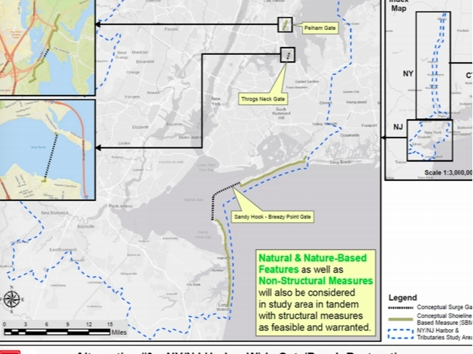
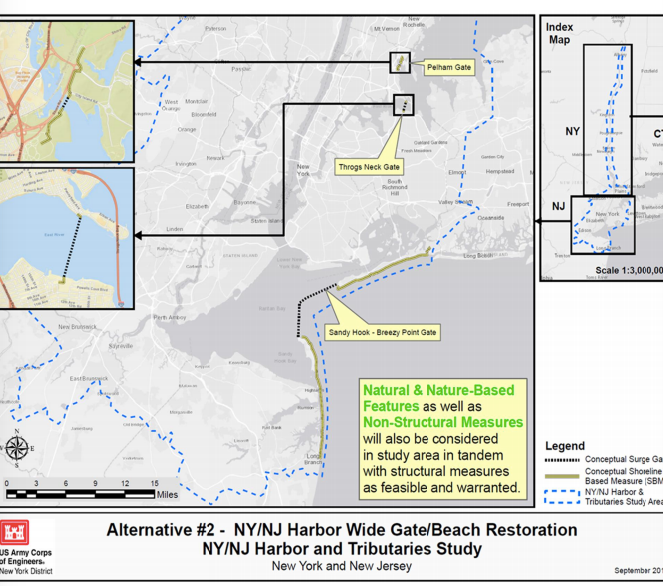
One of the proposals that appeared in multiple plans from the U.S. Army Corps of Engineers was to build a surge barrier enclosure in the East River, just west of the Throgs Neck Bridge. The storm surge barrier would stand from sea floor to well above sea-level and the gate would remain open so boats and fish could pass through, closing when storms approached.
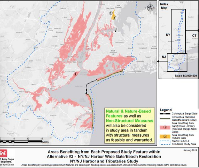
But critics of the plan feared the bridge protected New York City at the expense of North Shore communities, including Great Neck and Port Washington. The Port Washington-Manhasset Office of Emergency Management said it was "concerned" about the proposal. If followed through as planned, it could impact low-lying areas, including public spaces and the environment, the agency wrote in a Facebook post.
Find out what's happening in Great Neckfor free with the latest updates from Patch.
Tracy Brown, director of the nonprofit Save The Sound, told Patch in a statement the group was also concerned. When closed, the Throgs Neck floodgate could flood communities along the Long Island Sound.
"When closed, the proposed floodgate at Throgs Neck will create deflection flooding for the communities on the outside of the gate when storm surges hit," she said. "Even when open, the in-water structures of the gate will narrow that passageway, change tidal patterns and have other impacts on nearby communities that need to be fully understood before any plans are approved and construction begins. We need to weigh the new problems that will be created against the ones we are trying to solve before agreeing to spend billions of taxpayer dollars in the Army Corps proposals."
Find out what's happening in Great Neckfor free with the latest updates from Patch.
On Thursday, Bryce Wisemiller of the Army Corps of Engineers' New York district did his best to quash those fears.
When it comes to the Throgs Neck floodgate proposals specifically, "those two alternatives are looking less and less likely to be selected as part of a plan," he said to a smattering of applause.
"There's a lot of studies underway, there's a lot of evaluations yet to do, but I did want to make that point initially so people have that in mind," Wisemiller said.
In response to a resident's question about what how the engineers plan to protect Little Neck, Manhasset, Hempstead Harbor and Manorhaven, Wisemiller singled out low-lying Manorhaven as a "very concerning area" — as well as North Port Washington — when it comes to coastal storms.
"The study area right now is constrained by areas that have not been evaluated previously," he said. "So there have been studies done back in the '60s for that area, but I would suggest that if you have concerns about how to deal with coastal storms in northern Nassau County, or other areas like that — there are several of them around — that you reach out to your elected officials. And then reach out to the corps. We can't do studies without partners asking us to do them."
The group was tasked with finding ways to reduce flood risk across New York and New Jersey. They hope to make these areas more resilient to storms and ease the economic toll and risks that hurricanes and nor'easters. The proposals also aim to curb flooding exacerbated by rising sea levels.
Federal engineers drafted several ideas designed to reduce flood risks across more than 2,100 square miles stretching from the southern tip of the New Jersey coastline all the way north to New York's Capital region and east into Nassau County. The updated proposals presented Thursday will be uploaded to the Army Corps of Engineers' website Friday, officials said.
In an interim report released in February, one plan would install a combination levee berm and surge gate/barrier system connecting Sandy Hook, New Jersey, across to Breezy Point on the Rockaway peninsula.
The second part of the project would involve a relatively small embayment — a recess in a coastline that forms a bay — next to Pelham Bay Park in the Bronx along the western Long Island Sound.
Get more local news delivered straight to your inbox. Sign up for free Patch newsletters and alerts.