Weather
Wild Weather Weekend Ahead For Long Island
BREAKING: Get those air conditioners ready. It will be warm enough to head to the beach, but thunderstorms may keep you inside.


A warm April Friday on Long Island will be followed by an even warmer Saturday, with temperatures expected to climb into the 80s. But an 80-degree sunny April Saturday is apparently too much to ask for from Mother Nature, as showers and thunderstorms may keep you inside scrambling to find that air conditioner you somehow misplaced.
But any wet weather Saturday should end by the afternoon, so if you don't mind mostly cloudy skies and you couldn't sneak out of work early on a downright gorgeous Friday, it could be a fine day for the first beach trip of the year.
Sunday will bring much more seasonable temperatures with highs near 60. There's also a slight chance of thunderstorms.
Find out what's happening in Medfordfor free with the latest updates from Patch.
Temperatures are expected to be several degrees above normal for the coming work week, but this Saturday could end up being the warmest day on the island for at least a couple weeks. 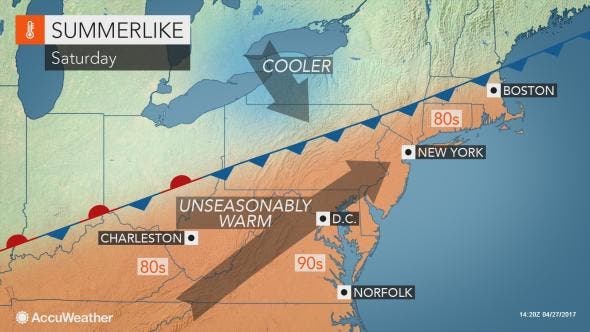
"We expect more significant cooling to take place during the first weekend and second week of May," AccuWeather Lead Long-Range Meteorologist Paul Pastelok said.
Find out what's happening in Medfordfor free with the latest updates from Patch.
"We have been getting mixed signals as to the magnitude of the cooling trend before the middle of May," he said, "but we suspect temperatures may dip below average a bit for much of the second week, followed by near- to above-average temperatures for much of the second half of the month in the Northeast."
The full forecast from the National Weather Service:
Friday Afternoon- Sunny, with a high near 76. Southwest wind around 11 mph.
Friday Night-Patchy fog after 4am. Otherwise, increasing clouds, with a low around 58. Southwest wind 5 to 8 mph.
Saturday- Showers likely and possibly a thunderstorm before 9am, then a chance of showers and thunderstorms between 9am and noon. Patchy fog before 9am. Otherwise, mostly cloudy, with a high near 81. South wind 7 to 14 mph. Chance of precipitation is 60%.
Saturday Night- Mostly cloudy, with a low around 54. Northwest wind 6 to 9 mph becoming north after midnight.
Sunday- A 20 percent chance of showers and thunderstorms. Partly sunny, with a high near 61. Northeast wind 8 to 11 mph, with gusts as high as 21 mph.
Sunday Night- A 30 percent chance of showers. Mostly cloudy, with a low around 49.
Monday-A 30 percent chance of showers after 1pm. Mostly cloudy, with a high near 69.
Monday Night- A chance of showers, then showers likely and possibly a thunderstorm after 7pm. Mostly cloudy, with a low around 57. Chance of precipitation is 60%.
Tuesday- Partly sunny, with a high near 70.
Tuesday Night- Partly cloudy, with a low around 51.
Wednesday- Mostly sunny, with a high near 67.
Wednesday Night-Partly cloudy, with a low around 49.
Thursday- A 40 percent chance of showers. Partly sunny, with a high near 61.
Get more local news delivered straight to your inbox. Sign up for free Patch newsletters and alerts.