Weather
Big Temperature Swings, Rain In Hudson Valley Forecast: NWS
Find out the latest weather prediction through the weekend, according to meteorologists.

HUDSON VALLEY, NY — A mild, pleasant and spring-like day today will give way to rain tonight and into early Friday, according to meteorologists.
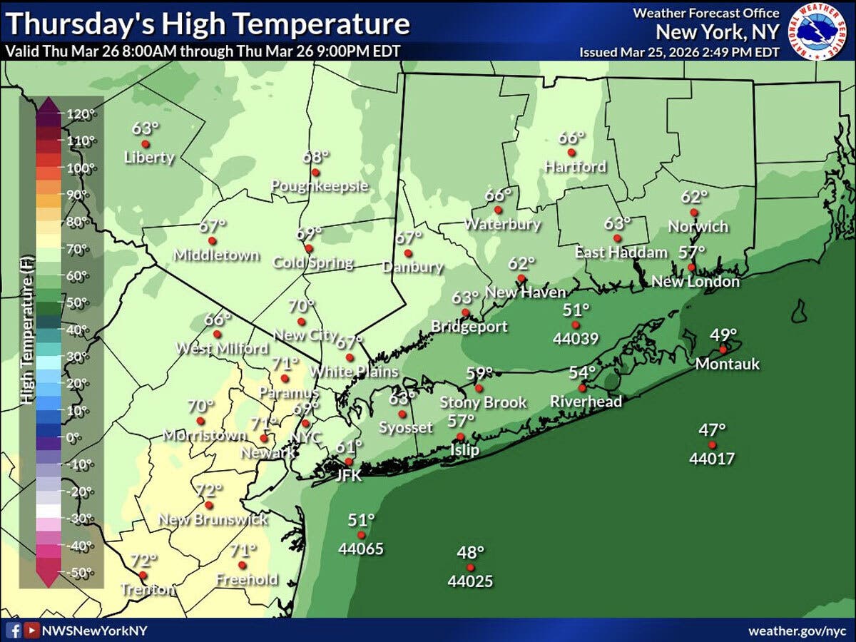
The National Weather Service predicts today will be the warmest day of the week, and high temperatures may reach around 70 degrees in the Hudson Valley.
An approaching cold front will bring changes to the weather pattern later today, then rain will develop, including some “embedded downpours,” according to the National Weather Service.
Find out what's happening in Mid Hudson Valleyfor free with the latest updates from Patch.
Rain is expected overnight Thursday and will taper off early Friday morning, forecasters said.
After the rain, expect much cooler temperatures, with highs on Friday only reaching the upper 40s, the National Weather Service predicts.
Find out what's happening in Mid Hudson Valleyfor free with the latest updates from Patch.
The weekend is expected to be dry, with chilly temperatures on Saturday, when highs will be hovering around 40.
The second half of the weekend will be slightly warmer and more seasonal, with highs reaching around 50 degrees during the day Sunday, according to the National Weather Service.
Here are the forecast details for the lower Hudson Valley area via the National Weather Service:
Today: A 30 percent chance of showers after 5 p.m. Mostly sunny, with a high near 70. Southwest wind around 11 mph, with gusts as high as 22 mph.
Tonight: Showers. Low around 46. South wind 10 to 13 mph becoming northwest after midnight. Winds could gust as high as 24 mph. Chance of precipitation is 80%. New precipitation amounts between a tenth and quarter of an inch possible.
Friday: Showers likely, mainly before 8 a.m. Cloudy, with a temperature falling to around 47 by 9 a.m. North wind 10 to 14 mph. Chance of precipitation is 60%.
Friday Night: A slight chance of rain after 8 p.m, mixing with snow after 5 a.m. Mostly cloudy, with a low around 30. Wind chill values between 25 and 30. North wind 6 to 9 mph. Chance of precipitation is 20%.
Saturday: Mostly sunny, with a high near 41. Northwest wind around 14 mph, with gusts as high as 24 mph.
Saturday Night: Partly cloudy, with a low around 28.
Sunday: Mostly sunny, with a high near 50.
Here are the forecast details for the Mid-Hudson Valley area via the National Weather Service:
Today: A chance of rain, mainly after 4 p.m. Partly sunny, with a high near 70. Southwest wind 8 to 11 mph, with gusts as high as 25 mph. Chance of precipitation is 30%. New precipitation amounts of less than a tenth of an inch possible.
Tonight: Rain. Low around 43. Southwest wind 5 to 7 mph becoming north after midnight. Winds could gust as high as 23 mph. Chance of precipitation is 80%. New precipitation amounts between a half and three quarters of an inch possible.
Friday: A chance of showers, mainly before 8 a.m. Mostly cloudy, with a high near 48. North wind 9 to 11 mph, with gusts as high as 23 mph. Chance of precipitation is 30%. New precipitation amounts of less than a tenth of an inch possible.
Friday Night: Partly cloudy, with a low around 26. North wind around 6 mph.
Saturday: Mostly sunny, with a high near 38. Northwest wind 6 to 9 mph.
Saturday Night: Partly cloudy, with a low around 25.
Sunday: Mostly sunny, with a high near 51.
Get more local news delivered straight to your inbox. Sign up for free Patch newsletters and alerts.