Weather
Hazardous Weather Outlook Issued For Hudson Valley
Potentially severe thunderstorms are in the forecast, find out the latest timeline.

HUDSON VALLEY, NY — A hazardous weather outlook alert has been issued for southeast New York due to the risk for severe weather.
Thunderstorms, including potentially damaging wind gusts, are in the forecast today and tonight, according to the National Weather Service.
The National Weather Service predicts a strong line of severe thunderstorms will cross through a large portion of the region through this afternoon.
Find out what's happening in Mid Hudson Valleyfor free with the latest updates from Patch.
If you are traveling to the north, be aware of a tornado watch in effect until 3 p.m. today.
A National Weather Service report shows portions of the Hudson Valley within a two percent tornado risk, with a slight uptick, to five percent, to the north.
Find out what's happening in Mid Hudson Valleyfor free with the latest updates from Patch.
See map:
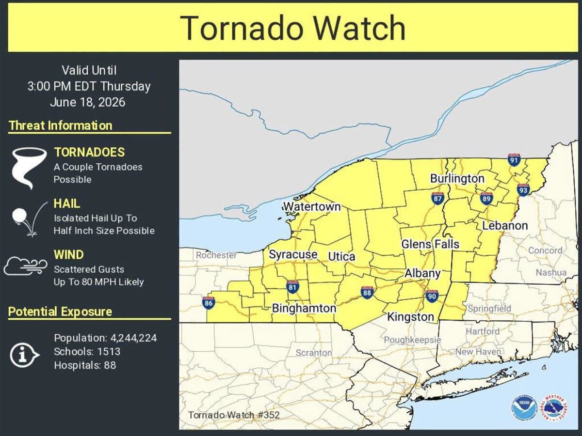
“A couple of tornadoes are possible along with a high likelihood of strong to damaging wind gusts,” the National Weather Service said. “A tornado watch has been issued for portions of eastern New York and western New England through 3 p.m. this afternoon.”
The National Weather Service advises residents to monitor warnings, follow the latest weather advisories and secure outdoor objects.
For much of the Hudson Valley today, gusty winds are the primary concern. The National Weather Service reports chances for showers and thunderstorms this afternoon.
“Some of the storms could be severe,” the National Weather Service said.
After today, much quieter weather arrives in the region. Friday through Sunday, or Father’s Day, are expected to be dry, with daytime high temperatures around 80 degrees, according to the National Weather Service.
Here are the forecast details for the Mid-Hudson Valley area via the National Weather Service:
Today: A chance of showers and thunderstorms before 1 p.m., then showers likely and possibly a thunderstorm between 1 p.m. and 2 p.m., then a chance of showers and thunderstorms after 2 p.m. Some of the storms could be severe. Mostly cloudy, then gradually becoming sunny, with a high near 86. Southwest wind around 14 mph, with gusts as high as 39 mph. Chance of precipitation is 60%. New rainfall amounts between a tenth and quarter of an inch, except higher amounts possible in thunderstorms.
Tonight: Partly cloudy, with a low around 61. Southwest wind 6 to 10 mph, with gusts as high as 24 mph.
Juneteenth: Sunny, with a high near 83. West wind 7 to 11 mph, with gusts as high as 21 mph.
Friday Night: Mostly clear, with a low around 59. West wind 3 to 6 mph.
Saturday: Sunny, with a high near 81. West wind 9 to 13 mph, with gusts as high as 24 mph.
Saturday Night: Mostly clear, with a low around 57.
Sunday: Sunny, with a high near 83.
Sunday Night: A chance of showers after 2 a.m. Mostly cloudy, with a low around 59. Chance of precipitation is 40%.
Here are the forecast details for the lower Hudson Valley area via the National Weather Service:
Today: A 40 percent chance of showers and thunderstorms, mainly after noon. Mostly cloudy, with a high near 89. Breezy, with a southwest wind 13 to 21 mph, with gusts as high as 33 mph.
Tonight: Partly cloudy, with a low around 65. Breezy, with a west wind 15 to 23 mph, with gusts as high as 39 mph.
Juneteenth: Mostly cloudy, then gradually becoming sunny, with a high near 81. West wind 10 to 13 mph.
Friday Night: Mostly clear, with a low around 61. West wind around 10 mph.
Saturday: Sunny, with a high near 81. West wind 13 to 15 mph, with gusts as high as 25 mph.
Saturday Night: Mostly clear, with a low around 60.
Sunday: Mostly sunny, with a high near 81.
Sunday Night: A 40 percent chance of showers after 2 a.m. Mostly cloudy, with a low around 63.
Get more local news delivered straight to your inbox. Sign up for free Patch newsletters and alerts.