Weather
Heat Advisories Issued For Hudson Valley; Potentially Severe Thunderstorms In Forecast: NWS
Find out when oppressive heat, humidity and storms will be impacting the region, according to meteorologists.

HUDSON VALLEY, NY — Oppressive heat and thunderstorms are in the daily forecast for the region through Friday.
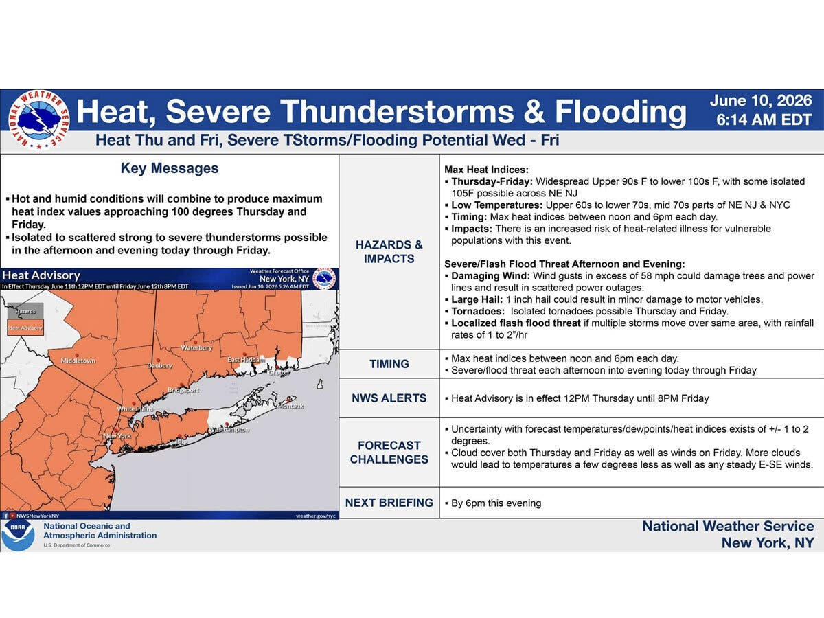
A hazardous weather outlook has been issued for southeast New York, with heat advisories in effect from noon to 8 p.m. on both Thursday and Friday.
Heat index values could reach up to 98 degrees on Thursday and 102 degrees on Friday. Hot temperatures combined with high humidity could cause heat-related illnesses, according to the National Weather Service.
Find out what's happening in Mid Hudson Valleyfor free with the latest updates from Patch.
It advises drinking plenty of fluids and staying in air conditioning when possible. If working outside, take frequent breaks.
There is also a “marginal risk” of severe thunderstorms this afternoon and evening, and possible strong to severe thunderstorms Thursday and Friday, primarily in the afternoon and evening for both days.
Find out what's happening in Mid Hudson Valleyfor free with the latest updates from Patch.
“Isolated to scattered strong to severe thunderstorms possible in the afternoon and evening today through Friday,” the National Weather Service said.
Severe thunderstorms could bring damaging wind, power outages, flooding and hail, with “isolated tornadoes possible Thursday and Friday.”
Here are the forecast details for the Mid-Hudson Valley area via the National Weather Service:
This Afternoon: A chance of showers and thunderstorms, mainly after 4 p.m. Partly sunny, with a high near 87. South wind around 8 mph. Chance of precipitation is 30%. New rainfall amounts of less than a tenth of an inch, except higher amounts possible in thunderstorms.
Tonight: Showers and thunderstorms likely before midnight, then a slight chance of showers between midnight and 1 a.m. Patchy fog between 4 a.m. and 5 a.m. Otherwise, mostly cloudy, then gradually becoming mostly clear, with a low around 67. South wind around 5 mph becoming calm in the evening. Chance of precipitation is 60%. New precipitation amounts of less than a tenth of an inch, except higher amounts possible in thunderstorms.
Thursday: A chance of showers and thunderstorms between 2 p.m. and 5 p.m., then showers likely and possibly a thunderstorm after 5 p.m. Some of the storms could be severe. Patchy fog before 8 a.m. Otherwise, partly sunny and hot, with a high near 93. Heat index values as high as 99. Calm wind becoming west 5 to 7 mph in the afternoon. Chance of precipitation is 60%. New rainfall amounts of less than a tenth of an inch, except higher amounts possible in thunderstorms.
Thursday Night: Showers likely and possibly a thunderstorm before 8 p.m., then a chance of showers and thunderstorms between 8 p.m. and 11 p.m. Some of the storms could be severe. Mostly cloudy, with a low around 69. Calm wind. Chance of precipitation is 60%. New precipitation amounts of less than a tenth of an inch, except higher amounts possible in thunderstorms.
Friday: A chance of showers and thunderstorms after 2 p.m. Patchy fog before 7 a.m. Otherwise, mostly sunny and hot, with a high near 95. Calm wind becoming west around 5 mph in the afternoon. Chance of precipitation is 50%. New rainfall amounts of less than a tenth of an inch, except higher amounts possible in thunderstorms.
Friday Night: A chance of showers and thunderstorms before 11 p.m., then a chance of showers between 11 p.m. and 2 a.m. Mostly cloudy, with a low around 65. Chance of precipitation is 50%. New precipitation amounts between a tenth and quarter of an inch, except higher amounts possible in thunderstorms.
Saturday: Sunny and hot, with a high near 92.
Here are the forecast details for the lower Hudson Valley area via the National Weather Service:
This Afternoon: A chance of thunderstorms after 5 p.m. Partly sunny, with a high near 82. South wind around 10 mph. Chance of precipitation is 30%.
Tonight: A 40 percent chance of showers and thunderstorms before 2 a.m. Mostly cloudy, with a low around 71. South wind 5 to 7 mph becoming southwest after midnight.
Thursday: A 30 percent chance of showers and thunderstorms, mainly after 5 p.m. Partly sunny, with a high near 93. Heat index values as high as 99. West wind 6 to 9 mph.
Thursday Night: A chance of showers and thunderstorms before 11 p.m., then a slight chance of showers between 11 p.m. and 2 a.m. Cloudy, then gradually becoming partly cloudy, with a low around 71. West wind 5 to 7 mph. Chance of precipitation is 50%.
Friday: A chance of showers between 2 p.m. and 5 p.m., then a chance of showers and thunderstorms after 5 p.m. Mostly sunny, with a high near 94. West wind 3 to 7 mph. Chance of precipitation is 50%.
Friday Night: A chance of showers and thunderstorms before 11 p.m., then a chance of showers between 11 p.m. and 2 a.m. Mostly cloudy, then gradually becoming mostly clear, with a low around 68. Chance of precipitation is 50%.
Saturday: Sunny, with a high near 88.
Get more local news delivered straight to your inbox. Sign up for free Patch newsletters and alerts.