Home & Garden
More Winter Coming for the Mid-Hudson Valley: Work Week Weather
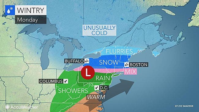
There's a Winter Weather Advisory going Monday. It's going to be a cold couple of days.

The latest storm brought more snow Monday morning, causing some school districts in the Hudson Valley to delay opening for a couple of hours.
And the National Weather Service issued a Winter Weather Advisory till 6 p.m.
Quite a contrast, eh? On Friday in Poughkeepsie the high was 78 degrees and 36 hours later, it was 33 degrees, Hudson Valley Weather pointed out.
Find out what's happening in Mid Hudson Valleyfor free with the latest updates from Patch.
The arctic chill that set in Saturday will continue for the next few days. That plus rain, sleet and snow on Monday could make for a tricky Tuesday commute.
"Plunging temperatures Monday night will cause any wet or slushy areas on untreated roads and sidewalks in New England or southern New England to freeze," AccuWeather Senior Meteorologist Kristina Pydynowski said.
Find out what's happening in Mid Hudson Valleyfor free with the latest updates from Patch.
While the snow chances end for at least now, Mother Nature is keeping a lid on temperatures this week. It’s going to feel like winter several days this week, and we could drop into the teens late Tuesday.
Want hour to hour info: Click here for an in-depth weather forecast for Mid-Hudson Valley Patch.
Here's what Hudson Valley Weather has for the work week:
- Monday - rain and snow showers High: 39 degrees. Snow tapering off to wet showers by mid-morning. Mix of rain and wet snow in the afternoon. North wind 5-10 mph.
- Monday night - Evening scattered snow showers... then clearing and turning bitter. Near record cold. Low in the upper 10s. Wind Chills near 10°. North wind 5 to 10mph, with a few gusts. [Record = 17° in 1964]
- Tuesday - Partly cloudy with a bitter breeze. High in the upper 30s. Wind Chill in the low 20s. NW wind at 5 to 15mph.
- Tuesday night - Mostly clear with possible record breaking cold. Low in the upper teens. [Record = 18° in 1982] NW wind around 5mph.
- Wednesday - Partly cloudy... with some increasing afternoon clouds. Cold. High in the mid 40s.
- Wednesday night - Cloudy with a spotty shower possible after midnight. Low in the upper 30s.
- Thursday - Cloudy... periods of rain. Rain could be heavy in the afternoon. High in the upper 50s.
- Thursday night - Evening showers... followed by considerable cloudiness overnight. Low in the mid 30s.
- Friday - Clouds with a few breaks of sun... very cold. High in the mid 40s.
- Friday night - Variable cloudiness and very cold. Low in the mid 20s.
Photo credit: Accuweather.com
Get more local news delivered straight to your inbox. Sign up for free Patch newsletters and alerts.