Weather
Timeline, Details Released On Thunderstorm Threat For Hudson Valley
Find out when thunderstorms may impact the Hudson Valley region, plus the latest forecast for the holiday weekend.

HUDSON VALLEY, NY — Thunderstorms are in the forecast for the region on Thursday, then the holiday weekend is expected to be sunny and dry, according to meteorologists.
The National Weather Service reports showers and scattered thunderstorms are likely mid-day into the afternoon on Thursday.
“It is possible some of these storms may become severe,” the National Weather Service said. “Damaging winds are the main concern.”
Find out what's happening in Mid Hudson Valleyfor free with the latest updates from Patch.
Wind gusts could reach around 30 miles per hour, potentially resulting in downed tree limbs. The thunderstorms are possible Thursday due to a cold front passing through, forecasters said.
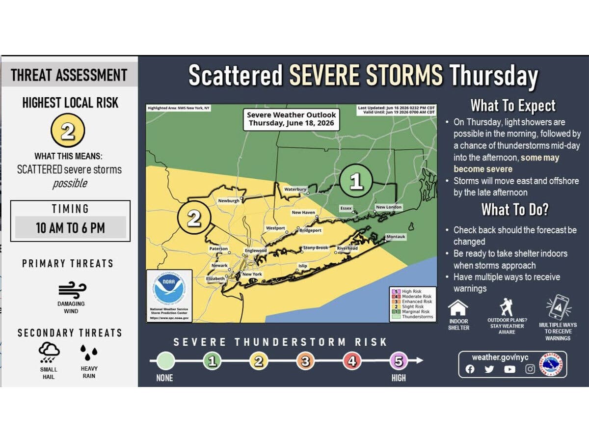
The National Weather Service is estimating the chance of precipitation in the mid-Hudson Valley at 90 percent on Thursday. For the lower Hudson Valley, the chance is around 70 percent.
Find out what's happening in Mid Hudson Valleyfor free with the latest updates from Patch.
High temperatures on Thursday will reach into the mid-80s.
Holiday weekend
After Thursday’s unsettled weather, the pattern turns dry and clear, according to meteorologists.
The National Weather Service predicts Friday, Saturday and Father’s Day on Sunday will all be sunny, with high daytime temperatures around 80 degrees.
Here are the forecast details for the Mid-Hudson Valley area via the National Weather Service:
This Afternoon: A chance of showers and thunderstorms, mainly after 3 p.m. Partly sunny, with a high near 81. South wind around 7 mph. Chance of precipitation is 30%. New rainfall amounts of less than a tenth of an inch, except higher amounts possible in thunderstorms.
Tonight: A slight chance of showers and thunderstorms, then a chance of showers after 11 p.m. Mostly cloudy, with a low around 61. South wind around 5 mph becoming calm in the evening. Chance of precipitation is 30%. New precipitation amounts of less than a tenth of an inch, except higher amounts possible in thunderstorms.
Thursday: Showers and possibly a thunderstorm before 2 p.m., then a chance of showers and thunderstorms between 2 p.m. and 3 p.m. High near 85. South wind 10 to 15 mph, with gusts as high as 31 mph. Chance of precipitation is 90%. New rainfall amounts between a tenth and quarter of an inch, except higher amounts possible in thunderstorms.
Thursday Night: Mostly clear, with a low around 61. West wind 6 to 8 mph, with gusts as high as 21 mph.
Juneteenth: Sunny, with a high near 82. West wind 7 to 11 mph, with gusts as high as 23 mph.
Friday Night: Mostly clear, with a low around 58.
Saturday: Sunny, with a high near 80.
Saturday Night: Mostly clear, with a low around 58.
Sunday: Sunny, with a high near 81.
Here are the forecast details for the lower Hudson Valley area via the National Weather Service:
This Afternoon: A 20 percent chance of showers after 2 p.m. Mostly sunny, with a high near 78. South wind around 10 mph.
Tonight: Increasing clouds, with a low around 62. Southeast wind 6 to 8 mph.
Thursday: Showers likely, with thunderstorms also possible after 2 p.m. Cloudy through mid morning, then gradual clearing, with a high near 83. South wind 11 to 16 mph, with gusts as high as 28 mph. Chance of precipitation is 70%.
Thursday Night: Mostly clear, with a low around 65. West wind 8 to 13 mph, with gusts as high as 24 mph.
Juneteenth: Mostly sunny, with a high near 80. West wind 9 to 14 mph.
Friday Night: Mostly clear, with a low around 61.
Saturday: Sunny, with a high near 77.
Saturday Night: Mostly clear, with a low around 60.
Sunday: Sunny, with a high near 82.
Get more local news delivered straight to your inbox. Sign up for free Patch newsletters and alerts.