Community Corner
Hour-By-Hour Forecast for March's 1st Snow Storm
We'll let you know when it will snow the hardest in Nanuet, and if it ends before Monday's commute back to work and school.

Welcome to March—which looks a lot like February thus far.
A Winter Weather Advisory is in effect for Putnam, Rockland and northern Westchester, which could receive up to six inches of snow beginning later today and ending early Monday, just in time for another enjoyable commute back to work.
The National Weather Service warns that snow-covered surfaces will cause travel difficulties and hide already icy spots.
Find out what's happening in Nanuetfor free with the latest updates from Patch.
There seems to be new accumulating snow every Monday, so in reality this is becoming old hat for us.
The NWS predicts total accumulation of 4-6 inches. Bill Potter over at Hudson Valley Weather says dry air along the northern edge of the storm could lower totals in the mid-Hudson Valley.
Find out what's happening in Nanuetfor free with the latest updates from Patch.
Now the timing of the snow, from weather.com
Through 4PM: light snow, with temperatures steadily rising and light winds from the south-southeast
5PM: light snow and fog, 29 degrees.
6-8PM: snow begins in earnest, temperatures drop a little
9-10PM: temperatures rise again and the snow continues
12AM: precipitation has turned into the classic “wintry mix” temporarily
1AM: light snow. 31 degrees.
2-4AM: snow showers end
6AM: 30 degrees and mostly cloudy
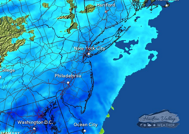
RADAR MAP: Hudson Valley Weather
» News Alerts: Subscribe to a free email newsletter:
BEDFORD-KATONAH • BRONXVILLE-EASTCHESTER-TUCKAHOE •CHAPPAQUA-MOUNT KISCO • HARRISON • LARCHMONT-MAMARONECK • NANUET • NEW CITY • NEW ROCHELLE • NYACK-PIERMONT • OSSINING-CROTON-ON-HUDSON • PEARL RIVER •PEEKSKILL-CORTLANDT • PELHAM • PORT CHESTER •PLEASANTVILLE-BRIARCLIFF MANOR • RIVERTOWNS • RYE •SCARSDALE • SOUTHEAST-BREWSTER • TARRYTOWN-SLEEPY HOLLOW • WHITE PLAINS • YORKTOWN-SOMERS
Get more local news delivered straight to your inbox. Sign up for free Patch newsletters and alerts.