Home & Garden
Winter Weather Advisory for Nanuet
It begins at 8PM and runs through the Tuesday morning commute. Here are the details.

The National Weather Service has issued two statements:
- Winter Weather Advisory in effect from December 28, 08:00 PM EST until December 29, 11:00 AM EST
- Hazardous Weather Outlook
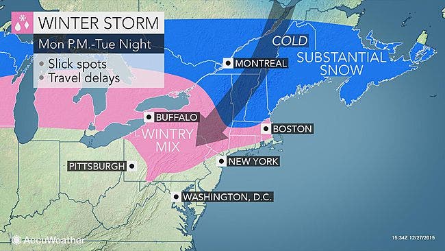
HAZARD TYPES...SLEET AND FREEZING RAIN. * ACCUMULATIONS...SNOW ACCUMULATION OF UP TO 1 INCH...ALONG WITH FROM AROUND A TRACE TO UP TO A TENTH OF AN INCH OF ICE. * TIMING...A WINTRY MIX DEVELOPS ACROSS THE TRI-STATE FROM WEST TO EAST TONIGHT. THERE WILL BE A PROLONGED PERIOD OF SLEET AND LIGHT FREEZING RAIN ACROSS INTERIOR PORTIONS OF THE TRI-STATE INTO TUESDAY MORNING. * IMPACTS...SLIPPERY ROADWAYS AND SIDEWALKS. WITH THE MAIN THREAT BEING TO ELEVATED SURFACES AND HIGHER ELEVATIONS IN THE ADVISORY AREA. PRECAUTIONARY/PREPAREDNESS ACTIONS... A WINTER WEATHER ADVISORY MEANS THAT PERIODS OF SNOW...SLEET...OR FREEZING RAIN WILL CAUSE TRAVEL DIFFICULTIES. BE PREPARED FOR SLIPPERY ROADS AND LIMITED VISIBILITIES...AND USE CAUTION WHILE DRIVING.
“Temperatures at the surface will be cold enough to support snow, but up at cloud level, the warmth surges into the Hudson Valley,” says Bill Potter of Hudson Valley Weather. “This causes the precipitation to fall as rain, but there is a deep layer of cold air below the clouds, and that will freeze the rain droplets as they fall… and they reach the ground as sleet (ice pellets).
Find out what's happening in Nanuetfor free with the latest updates from Patch.
“The deep layer of cold air should hold on for several hours, and could give us an extended period of sleet… prior to mixing with freezing rain toward sunrise. This sets the stage for a treacherous Tuesday AM commute.”
Want hour to hour info: Click here for Nanuet’s in-depth weather forecast.
Find out what's happening in Nanuetfor free with the latest updates from Patch.
MAP: Accuweather.com
Get more local news delivered straight to your inbox. Sign up for free Patch newsletters and alerts.
