Weather
NYC Issues Travel Ban, Shutters Schools As Blizzard Arrives
Only essential personnel will be allowed on bridges, officials said.

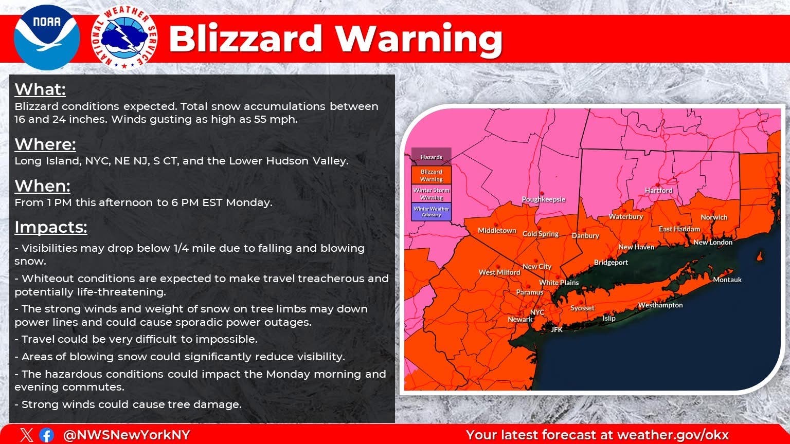
NEW YORK CITY — The National Weather Service has issued a blizzard warning for New York City, Governor Kathy Hochul declared a State of Emergency for the city and Mayor Zohran Mamdani has issued a travel ban as the major storm moves into the region Sunday.
Mamdani declared a state of emergency for the five boroughs Sunday and issued a travel ban. From 9 p.m. Sunday night until noon Monday, no vehicles are permitted on streets, bridges and highways.
He also closed all schools Monday.
Find out what's happening in New York Cityfor free with the latest updates from Patch.
The region faces the threat of coastal flooding, power outages and unsafe road conditions as the powerful nor'easter barrels down. Hochul warned residents to take the blizzard warning seriously and make preparations to ride out the storm.
“New Yorkers are no strangers to snow and cold weather, but these blizzard-like conditions approaching New York City, Long Island and the lower Mid-Hudson will bring heavy snow and strong winds, with the storm forecasted to impact much of our state,” Hochul said in a written statement. “As with every weather event, our state agencies are equipped with the resources they need to respond to the developing storm and keep everyone informed. I encourage everyone to take action, stay vigilant and always monitor your local forecast for real-time updates.”
Find out what's happening in New York Cityfor free with the latest updates from Patch.
The emergency declaration covers Albany, Bronx, Columbia, Greene, Delaware, Dutchess, Kings, Nassau, New York, Orange, Putnam, Queens, Richmond, Rockland, Suffolk, Schenectady, Schoharie, Sullivan, Ulster, Westchester and contiguous counties.
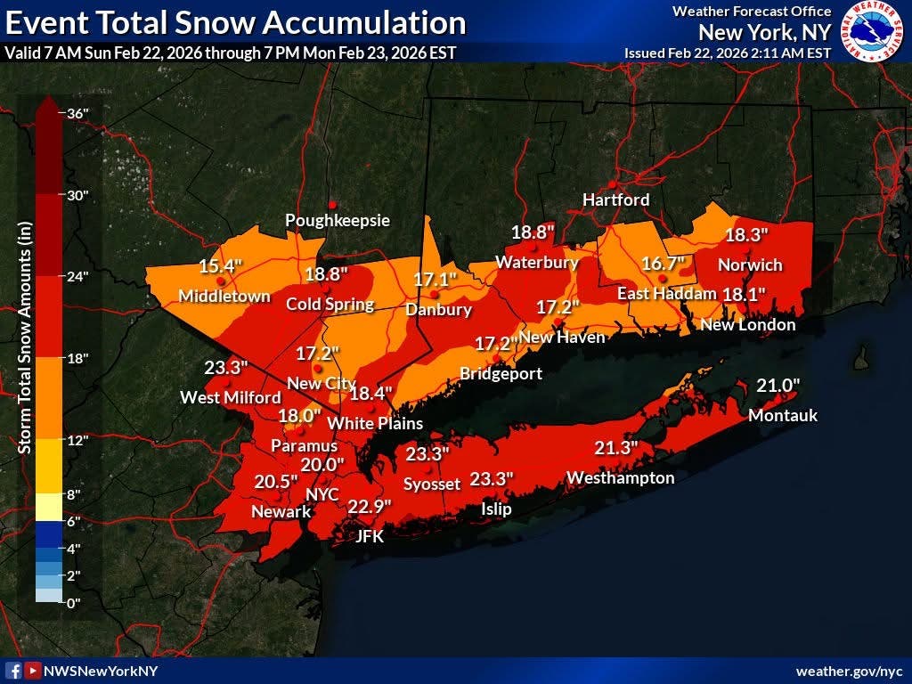
According to the governor's office, up to two feet of snow is expected to fall on New York City and Long Island while regions including the Hudson Valley and the Capital area could see as much as a foot of snow.
Additionally, wind gusts reaching 60 mph could cause whiteout conditions on the road, especially in New York City and on Long Island, the governor warned.
With the declaration, the governor called up 100 National Guard members and put more than 5,600 utility workers on standby to tackle anticipated power outages.
Light snow is expected to start falling Sunday morning through the afternoon. The heaviest amount of snow is poised to hit the area around 7 p.m. and continue through early Monday afternoon, according to the latest forecasts.
One to two inches of snow could fall per hour, but heavier amounts are expected as we go into the overnight hours.
Temperatures will drop below freezing Sunday evening.
Forecasters are advising drivers to not travel Sunday night. In preparation for the snow storm this weekend, the NWS has also issued a winter storm watch warning in effect through Monday afternoon.
On Monday, Long Island Rail Road plans to operate on a Sunday schedule with modifications as necessitated by evolving weather conditions, the governor's office announced. Metro-North Railroad will run hourly service on the Harlem, Hudson, and New Haven lines and weekend service on the Connecticut and Wassaic branches. Subway service changes and delays are expected overnight Sunday into Monday, as express tracks are used to store trains underground during heavy snowfall, Hochul added.
"Be ready to adjust travel plans Sunday and Monday morning, including caregiving schedules," the city's Emergency Management agency said in a social media post. "Avoid unnecessary travel Sunday and Monday morning if you can to allow snow operations crews to operate. If you are traveling, use mass transit and expect travel delays."
This is a developing story. This post may be updated.
Patch Staffer Paige Austin contributed to this report.
Get more local news delivered straight to your inbox. Sign up for free Patch newsletters and alerts.