Weather
Heat, Thunderstorms In the Hudson Valley Heading Into Passover, Easter
A hazardous outlook has already been issued for severe weather Wednesday and Thursday in the mid-Hudson. Here are the latest details.

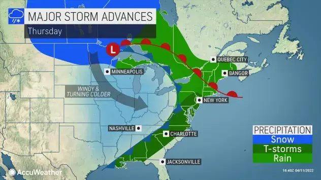
HUDSON VALLEY, NY — The region is moving into Passover and Easter with weather more like mid-May than mid-April, and that includes a marginal risk for severe thunderstorms mainly west of the Hudson River on Wednesday and in the northeastern Hudson Valley on Thursday.
The National Weather Service has issued a hazardous outlook for Dutchess and Ulster counties Tuesday. Strong to locally damaging winds will be the main threat along with brief, heavy downpours.
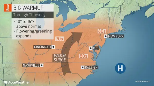
The heat will start Tuesday afternoon across the region, as temperatures rise into the upper 60s — about 10-15 degrees above average. It will peak Thursday when highs could reach the mid-70s or even 80 degrees.
Find out what's happening in New Cityfor free with the latest updates from Patch.
"Nighttime lows could be even more impressive than the daytime temperatures as conditions remain toasty well into the early morning hours of Thursday," said Jessica Storm, AccuWeather Meteorologist.
By the weekend things should become more seasonal. Temps will drop: into the mid-60s on Friday and Saturday then down into the mid-50s on Sunday.
Find out what's happening in New Cityfor free with the latest updates from Patch.
"Looking ahead - we will wrap the week up with a few more warm days, but colder air looks to return for next week, so soak it up!" said Alex Marra and Bill Potter at Hudson Valley Weather.
Passover is April 15-23. Easter is April 17. If you're traveling for the holiday, be aware of snow across much of the northwest and the northern Plains, followed by a massive storm system up and down the Mississippi valley and the Great Lakes.
Here's the 7-day forecast based on Rockland County:
- Tuesday - Mostly cloudy late this morning, then clearing. A chance of showers late this morning. Highs around 70. Northwest winds 5 to 10 mph. Chance of rain 50 percent.
- Tuesday night - Mostly clear in the evening, then becoming partly cloudy. Lows in the mid 40s. Northwest winds 5 to 10 mph, becoming north after midnight.
- Wednesday - Mostly cloudy. Highs in the lower 70s. East winds around 5 mph, becoming south in the afternoon.
- Wednesday Night - Mostly cloudy with a 40 percent chance of showers. Lows in the mid 50s. South winds around 5 mph.
- Thursday - Partly sunny in the morning, then mostly cloudy with showers likely with a chance of thunderstorms in the afternoon. Highs in the upper 70s. Southwest winds 5 to 10 mph. Gusts up to 20 mph in the afternoon. Chance of rain 60 percent.
- Thursday Night - Mostly cloudy. Showers likely with a chance of thunderstorms in the evening, then a chance of showers after midnight. Lows in the upper 40s. Chance of rain 60 percent.
- Friday - Mostly sunny. Highs in the mid 60s.
- Friday Night - Mostly clear in the evening, then becoming mostly cloudy. Lows in the upper 40s.
- Saturday - Partly sunny. A chance of showers in the afternoon. Highs in the mid 60s. Chance of rain 40 percent.
- Saturday Night - Mostly cloudy with a chance of showers in the evening, then partly cloudy after midnight. Lows around 40. Chance of rain 40 percent.
- Sunday - Mostly sunny. Highs in the lower 50s.
- Sunday Night - Partly cloudy. Lows in the upper 30s.
- Monday - Partly sunny. A chance of showers in the afternoon. Highs in the mid 50s. Chance of rain 40 percent.
Get more local news delivered straight to your inbox. Sign up for free Patch newsletters and alerts.