Weather
Hudson Valley Forecast: Hazardous Outlooks Issued
Frigid temps Tuesday and Wednesday nights should get everything cold enough for a possible bomb cyclone that could affect the region.

HUDSON VALLEY, NY — Bitter cold is descending, and another storm is lined up and looming, so the National Weather Service has issued hazardous outlooks for the region.
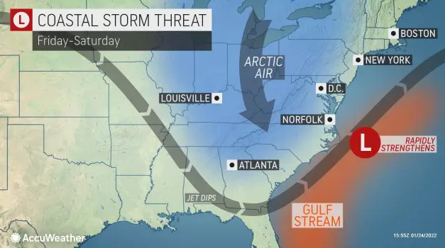
For Orange, Putnam, Rockland and Westchester counties, the NWS says: There is the potential for a coastal storm to bring heavy snowfall and high winds to portions of the area Friday night into Saturday night.
For Dutchess and Ulster, the NWS warned that bitterly cold temperatures are expected Tuesday and Wednesday nights with light winds. Wind chills near 20 below zero are possible over the higher elevations where wind chill advisories may be needed. Then there is potential Friday night for significant snowfall and windy conditions for eastern New York and western New England — depending on the storm track.
Find out what's happening in New Cityfor free with the latest updates from Patch.
"However, it is also possible that the main impacts remain east of our area," the NWS said.
Indeed. The folks at Hudson Valley Weather have been monitoring the storm system and the "rumor mill" around it for several days. Now they've made an preliminary statement.
Find out what's happening in New Cityfor free with the latest updates from Patch.
"We believe that as the energy responsible for this storm comes ashore today, and the sampling data of this energy is resolved by the models, we will begin to have a much better idea of what to expect," they said. "Until then, stay tuned and don’t get too caught up in the hype that’s now been building for at least the last 24-48 hours."
It's certainly going to be a big storm, with the potential to be classified as a bomb cyclone, said Alex Sosnowski, AccuWeather senior meteorologist. "Bombogenesis occurs when the central pressure of a storm crashes by 0.71 of an inch (24 millibars) or greater within 24 hours. When the pressure plummets, winds rush in toward the center of the storm at a faster pace. The winds can carry a great deal of moisture with them and unleash that in the form of copious amounts of precipitation. If the air is cold enough, heavy snow and blizzard conditions can ensue."
New England is most likely to bear the brunt this weekend, but parts of the mid-Atlantic could feel a glancing blow, he said.
"A westward shift in the storm's path of as little as 50 miles could mean areas from the Delmarva Peninsula through much of New Jersey and southeastern New York ... will pick up heavy snow and gusty winds that could lead to major travel disruptions," Sosnowski said. "On the other hand, a track 50 miles farther to the east could mean an all-out blizzard for Boston and Cape Cod with very little, if any, snow for the mid-Atlantic."
Get more local news delivered straight to your inbox. Sign up for free Patch newsletters and alerts.