Weather
Hudson Valley Forecast: Snow, Sleet And When It Will Warm Up
The workweek will end better after this bitter start. Here are the details.

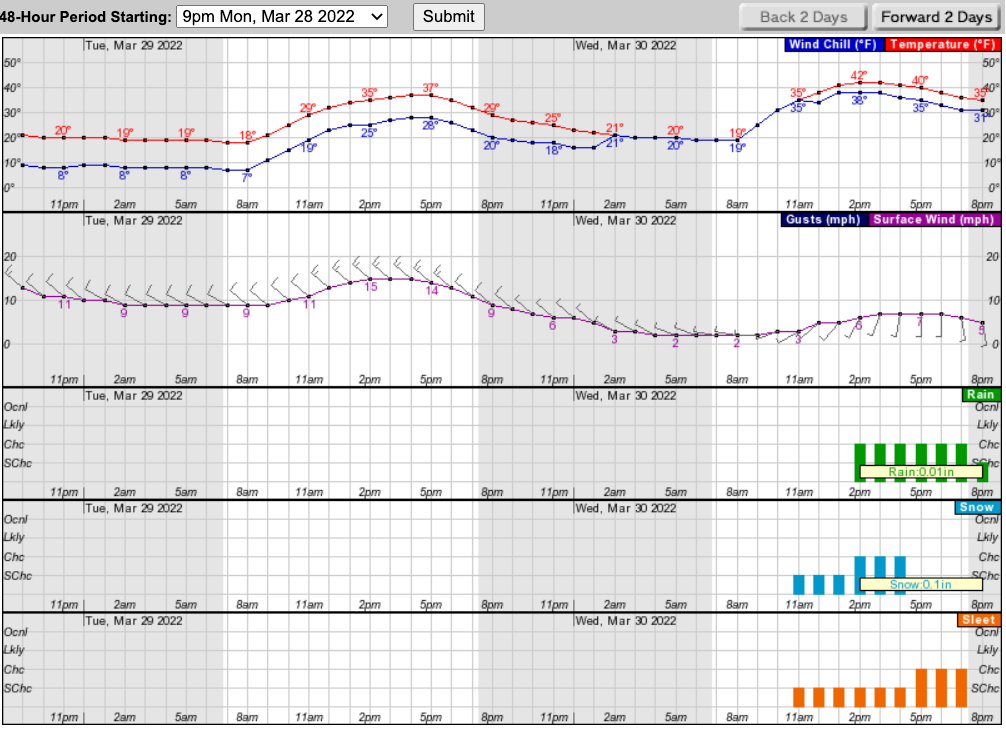
HUDSON VALLEY, NY — Snow flurries are kicking off the work week, while temperatures are shocking the system — and we'll see some sleet before we start to climb out of this arctic blast.
"Temps at mid-day are in the mid to upper 20s, roughly 20° below average for this time of year. When you factor in the wind, the real feel wind chills are in the single digits and teens!!" said the folks at Hudson Valley Weather. "This would be a bitter day by mid-winter standard … so for March 28th, it stings that much more."
Snow flurries and showers could create issues for the evening commute Monday and even the morning commute Tuesday.
Find out what's happening in New Cityfor free with the latest updates from Patch.
"Roads should be mainly wet, but watch for some slick and icy conditions in persistent snow showers," Hudson Valley Weather said.
The biting winds won't die down until Wednesday, and that's when a wintry mix of rain, snow and sleet will start, the National Weather Service predicts.
Find out what's happening in New Cityfor free with the latest updates from Patch.
A blip of more moderate temperatures on Thursday will be followed by freezing temps at night through the weekend.
Here's the five-day forecast based on northern Westchester:
- Monday Afternoon - Mostly cloudy with scattered flurries. Cold. Near steady temperature in the upper 20s. Northwest winds 15 to 20 mph with gusts up to 30 mph.
- Monday night - Partly cloudy with scattered flurries in the evening, then mostly clear after midnight. Cold with lows around 18. Northwest winds 15 to 20 mph with gusts up to 30 mph.
- Tuesday - Sunny. Highs in the upper 30s. Northwest winds 10 to 15 mph with gusts up to 25 mph.
- Tuesday Night - Mostly clear. Lows in the lower 20s. Northwest winds 10 to 15 mph. Gusts up to 25 mph in the evening.
- Wednesday - Partly sunny in the morning, then mostly cloudy with a chance of rain and snow in the afternoon. Highs in the mid 40s. Northwest winds around 5 mph, becoming southwest around 5 mph in the afternoon. Chance of precipitation 30 percent.
- Wednesday Night - Mostly cloudy. A chance of rain and sleet in the evening. Lows in the mid 30s. Chance of precipitation 30 percent.
- Thursday - Cloudy. Showers likely in the afternoon. Not as cool with highs in the lower 60s. Chance of rain 70 percent.
- Thursday Night - Showers with a chance of thunderstorms. Not as cool with lows around 50. Chance of rain 90 percent.
- Friday - Partly sunny. A chance of showers in the morning. Highs in the upper 50s. Chance of rain 40 percent.
- Friday Night - Partly cloudy. Cooler with lows in the mid 30s.
Get more local news delivered straight to your inbox. Sign up for free Patch newsletters and alerts.