Weather
Hudson Valley Outlook: Hazardous Weather, Then A Nor'Easter
Wet snow is possible along with heavy rain. Here's the latest.

HUDSON VALLEY, NY — The National Weather Service has issued a hazardous outlook for the lower Hudson Valley — and after that comes a nor'easter possibly bringing snow to the mid-Hudson.
A freeze watch is in effect for Rockland and Westchester counties from late Sunday night through Monday morning. Sub-freezing temperatures as low as 30 are possible. Frost and freeze conditions could kill crops, other sensitive vegetation and possibly damage unprotected outdoor plumbing.
That doesn't mean it won't be as cold or colder in Dutchess, Orange, Putnam and Ulster counties; however, communities there are used to freezing temps at night in mid-April.
Find out what's happening in New Cityfor free with the latest updates from Patch.
The setup on Sunday is that temperatures will be about 10 degrees below normal during the afternoon despite the sunshine. A breezy northwest flow may gust up to 30 mph at times, adding to the chill in the air. After dark comes the freeze.
And after that comes the nor'easter.
Find out what's happening in New Cityfor free with the latest updates from Patch.
"Monday clouds will increase ahead of our next storm system, which is looking more and more interesting for the Hudson Valley on Monday night," said Alex Marra and Bill Potter of Hudson Valley Weather.
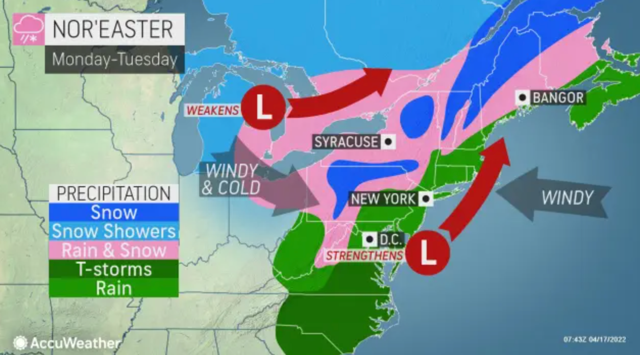
Temperatures are set to drop into the 20s and 30s across the Northeast, said AccuWeather Meteorologist Jessica Storm. Anyone with travel plans from the mountains of northern West Virginia and western Maryland to northern New York and northern Maine should keep tabs on the forecast for slushy and snowy conditions.
Here's the NWS five-day forecast based on Putnam County:
- Sunday - Mostly sunny. Cooler with highs in the upper 40s. Northwest winds 10 to 15 mph. Gusts up to 30 mph this afternoon.
- Sunday night - Mostly clear. Lows in the upper 20s. Northwest winds 10 to 15 mph with gusts up to 25 mph, becoming north around 5 mph after midnight.
- Monday - Sunny in the morning, then partly sunny with a slight chance of rain in the afternoon. Highs in the lower 50s. Northeast winds 5 to 10 mph, becoming southeast 10 to 15 mph with gusts up to 25 mph in the afternoon. Chance of rain 20 percent.
- Monday Night - Rain. Lows in the upper 30s. Southeast winds 10 to 15 mph, becoming northeast after midnight. Gusts up to 25 mph. Chance of rain near 100 percent.
- Tuesday - Mostly cloudy with rain in the morning, then partly sunny with a chance of rain in the afternoon. Highs in the upper 40s. Northwest winds 10 to 15 mph, becoming west in the afternoon. Gusts up to 30 mph. Chance of rain 80 percent.
- Tuesday Night - Partly cloudy. Lows in the upper 30s.
- Wednesday - Sunny. Highs in the mid 50s.
- Wednesday Night - Mostly clear in the evening, then becoming mostly cloudy. Lows in the upper 30s.
- Thursday - Mostly cloudy in the morning, then becoming partly sunny. Highs in the lower 60s.
- Thursday Night - Mostly cloudy in the evening, then becoming partly cloudy. Lows in the mid 40s.
Keep checking back with Patch for updates on the nor'easter.
Get more local news delivered straight to your inbox. Sign up for free Patch newsletters and alerts.


