Weather
Hudson Valley Snow Totals Up: Winter Weather Advisory Issued
Here's the latest including when it should end.

HUDSON VALLEY, NY — New projections made by the National Weather Service as snow began falling in the region early Sunday morning estimated total snow accumulations of 2 to 3 inches in Orange, Putnam, Rockland and Westchester counties, and 1-3 in Dutchess and Ulster.
Even that might be low. Observers were reporting 3+ inches in the mid-Hudson Valley around 9 a.m.
Snowfall so far, according to the NWS reports:
Find out what's happening in New Cityfor free with the latest updates from Patch.
- ORANGE COUNTY - 3.5 inches 1 mile west-northwest of Monroe as of 7 a.m.
- ROCKLAND COUNTY - 2.8 inches 1 mile northwest of Stony Point as of 7:30 a.m.
- WESTCHESTER COUNTY - 3.0 inches northwest of White Plains as of 8:30 a.m.
"Just how wrong were the models on this one?" said the folks at Hudson Valley Weather Sunday morning on Facebook. "The storm has tracked closer to the coast and in return spread more moderate precipitation into the region and further inland. As you can see, the data said some places now reporting 3" weren’t gonna get anything, our leaning on the higher side will still be underdone in some places (mostly mid HV south)."
The winter weather advisory is in effect until 1 p.m. The storm is expected to move away around noon from NYC and the Lower Hudson Valley but could linger into the mid-afternoon.
Find out what's happening in New Cityfor free with the latest updates from Patch.
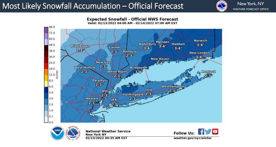
The official snowfall map Sunday morning upped the NWS estimates but was on the low side.
SEE ALSO: NYSP To Crack Down On Impaired Driving During Super Bowl Weekend
Get more local news delivered straight to your inbox. Sign up for free Patch newsletters and alerts.


