Weather
Timing, Totals Adjusted For Hudson Valley Weekend Storm
A blizzard to our north, an ice storm to our south — here's the latest on how the Hudson Valley fits in.


Heavy mixed precipitation is expected across the Hudson Valley Saturday through Sunday. When it will start and stop, and how much snow and ice will fall, depends on where in the valley you are.
The storm warnings issued by the National Weather Service:
- Goes into effect noon Saturday for Orange, Putnam, Rockland and northern Westchester and ends at 6 p.m. Sunday
- 4 p.m. for Dutchess and Ulster counties, ending at 4 p.m. Sunday
For southern Westchester:
Find out what's happening in New Cityfor free with the latest updates from Patch.
- The winter storm advisory runs from 4 p.m. Saturday to 10 a.m. Sunday.
- The coastal flooding advisory is in effect from 6 a.m. to 1 p.m. Sunday
"The storm enters the Hudson Valley near sunset, which will allow most daytime activities to be completed before conditions deteriorate," said Alex Marra and Bill Potter of Hudson Valley Weather. "But once the snow begins to fall, it will stick to all surfaces, and travel conditions will go downhill."
The National Weather Service says that some parts of the region could start seeing snow by 1 p.m.
Find out what's happening in New Cityfor free with the latest updates from Patch.
Dutchess, Orange, Putnam, Rockland, eastern Ulster and northern Westchester could see 6-10 inches of snow, made messy and packed down by sleet and rain and topped with ice. In the northern end of the region, higher amounts can be expected.
Southern Westchester is in for 2-4 inches of snow as part of a wintry mix plus rain topped with ice. Shallow flooding is expected in the most vulnerable locations near the waterfront and shoreline. Expect around 1 to 2 feet of inundation above ground level in low lying, vulnerable areas.


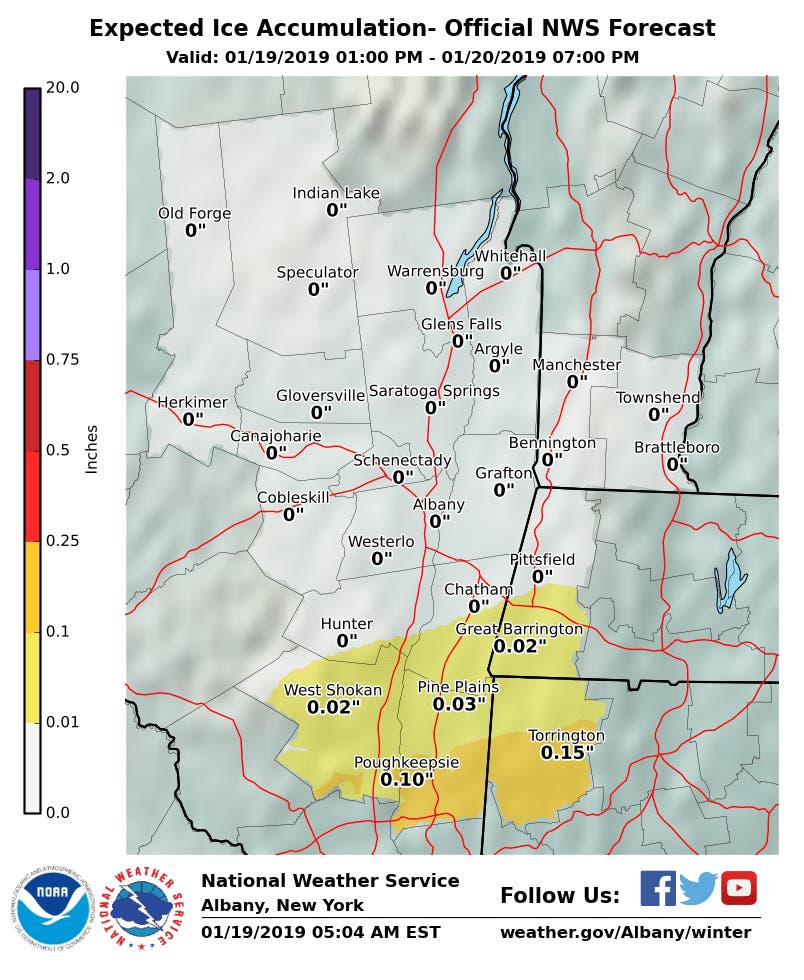
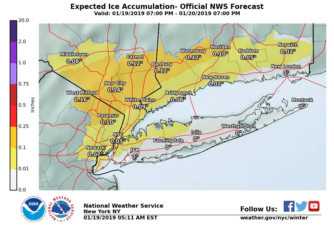
It looks as if the lower Hudson Valley can expect the brunt of the icefall (see maps below).
"A substantial amount of ice may accrue in the northern and western suburbs of New York City," said Alex Sosnowski, AccuWeather senior meteorologist. "Where freezing rain becomes the primary form of precipitation for a number of hours, the weight is likely to break tree limbs and cause power outages."
Temperatures may plummet 40 degrees Fahrenheit from their highest levels to their lowest levels, he said.
Wet and slushy areas will freeze. Any wet snow and ice will become difficult and perhaps impossible to remove. Ice ruts may form. The conditions will be dangerous for pedestrians and vehicular traffic on some secondary roads and city streets.
What is always changeable in our region is where and whether it will be warm enough to change to sleet or rain early or late in the storm.
"The snowfall forecast will verify or bust based on the position of the snow/ice transition line," Hudson Valley Weather said.
No matter what, travel should be very difficult everywhere, first with snowfall rates 1 to 3 inches per hour, then with sleet and freezing rain, then ice-rink-ready surfaces as temperatures plummet Sunday afternoon.
Images via AccuWeather.com, National Weather Service
» Check Out The Hudson Valley Patches' Facebook Pages
Sign up for Patch news alerts to get snow updates straight to your inbox.
Get more local news delivered straight to your inbox. Sign up for free Patch newsletters and alerts.