Weather
Town-by-Town Snow Predictions For The Hudson Valley
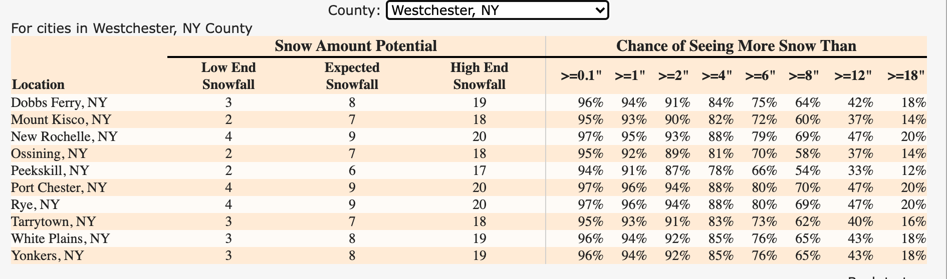
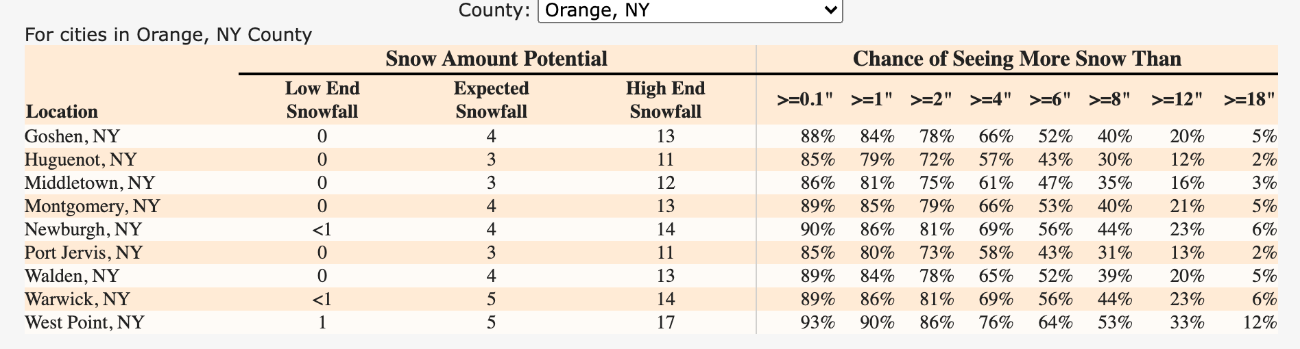
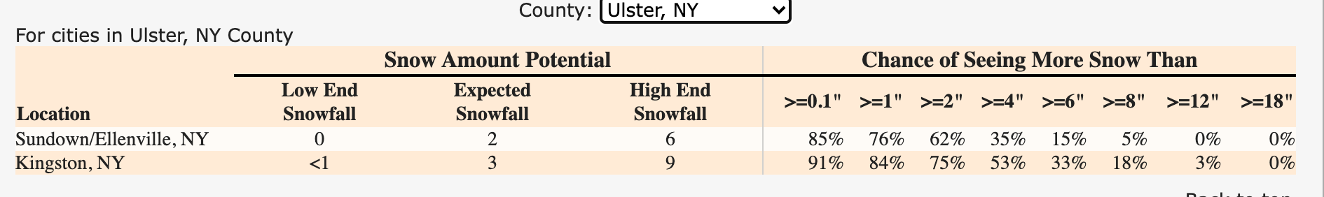
More accumulation is expected east of the Hudson River — Port Chester could get 9 inches of snow while Port Jervis could get 3.

HUDSON VALLEY, NY — Local and state officials are urging people to stay off the roads Saturday in the lower Hudson Valley, where snow could fall at a rate of 1 inch per hour for much of the day and gusty winds could cause near-blizzard conditions.
The National Weather Service has issued winter storm warnings for Westchester, Putnam and Rockland counties. There is a gale warning out for Long Island and coastal flooding is possible in southern Westchester Saturday morning.
And that's with the storm's path tracking southeast of our region. The closest blizzard warnings in effect are for eastern Long Island and southeast Connecticut.
Find out what's happening in New Cityfor free with the latest updates from Patch.
"The rapidly strengthening nor’easter is likely to be the strongest and most disruptive snowstorm and blizzard in several years for portions of New England and the immediate mid-Atlantic coast due to ferocious winds and snowfall rates that will have the ability to strand motorists, shut down major highways and airports and leave some communities isolated and in the dark," said AccuWeather meteorologists Ryan Adamson and Alex Sosnowski.
More accumulation is expected east of the Hudson River — Port Chester could get 9 inches while Port Jervis could get 3. There's a 47 percent chance that New Rochelle, Port Chester and Rye could get more than a foot of snow.
Find out what's happening in New Cityfor free with the latest updates from Patch.
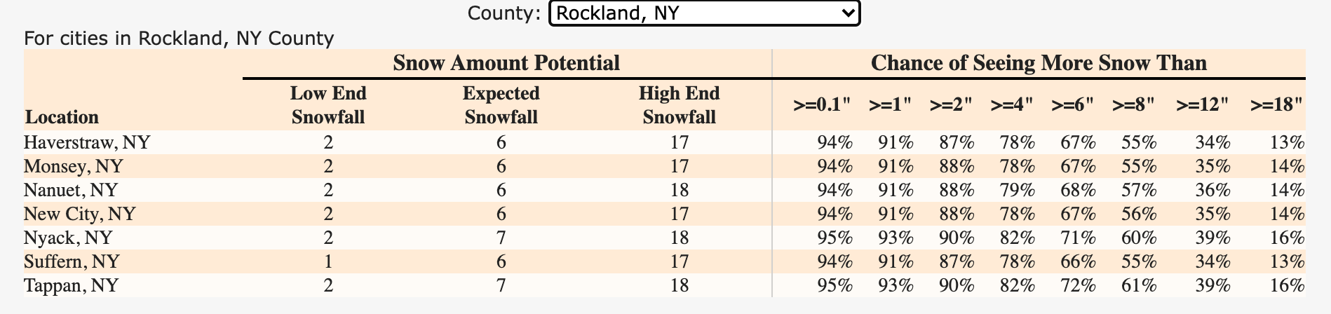
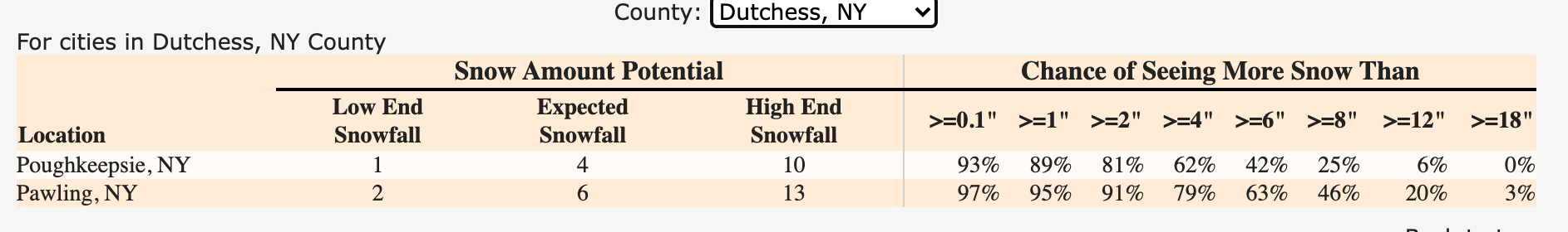
The National Weather Service released town-by-town estimates Friday:
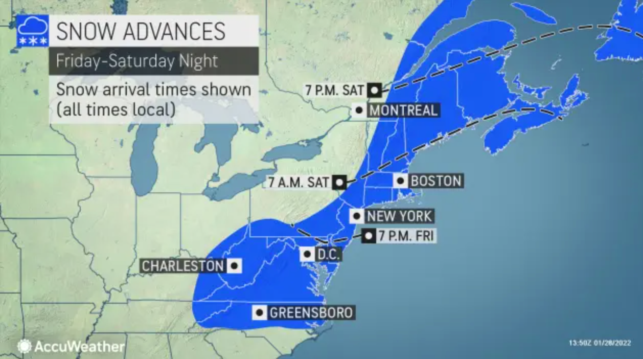
While flurries are possible Friday evening, the snow is expected to start falling heavily in the Hudson Valley after midnight and end between Saturday evening and early Sunday.
"This will be a very cold storm which is abnormal for our region, temps during the height of the storm will range from 5 to 15 degrees, Wind-Chills will remain below zero," said Alex Marra and Bill Potter of Hudson Valley Weather.
The powdery snow could fall so rapidly at times that visibility will diminish to near zero. Travel will become very difficult. If you must travel, keep an extra flashlight, food, and water in your vehicle in case of an emergency.
Strong winds on Saturday could cause scattered downed tree limbs and power lines.
State and local governments, transportation and utility agencies have set emergency plans in motion.
"The best way to handle this, is just stay home," said New York Gov. Kathy Hochul.
Bombogenesis, the term for what happens when barometric pressure plummets swiftly, is expected. The nor'easter will develop and rapidly strengthen into a bomb cyclone as it moves northward along the Eastern Seaboard. AccuWeather forecasters said.
Blizzard conditions are forecast from eastern Long Island through much of coastal New England, particularly from southeast Maine to Cape Cod. This will make travel nearly impossible, the NWS said. Significant beach erosion and coastal flooding will also be a concern.
"The intense storm has the potential to shut down airports, such as Boston Logan International Airport, and could lead to scores of flight cancellations in New York City, Philadelphia and Washington, D.C., that can have ripple effects across the nation as crews and aircraft are displaced," said Ryan Adamson, AccuWeather meteorologist.
Get more local news delivered straight to your inbox. Sign up for free Patch newsletters and alerts.