Home & Garden
Winter Storm Watch Issued for Rockland
"Wildcard" says Hudson Valley Weather. National Weather Service offers timing, severity predictions.

Forecasters say there is still a lot of uncertainty about the northern edge of the nor’easter coming this weekend.
“The most logical forecast right now is to say anyone from Saugerties to NYC is in a very wildcard position with this system,” said Alex Marra of Hudson Valley Weather.
Click here for New City’s in-depth weather forecast.
Find out what's happening in New Cityfor free with the latest updates from Patch.
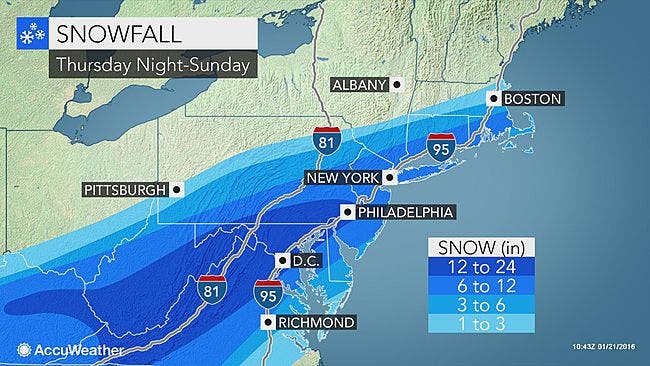
The reasons meteorologists are calling this storm such a big one are: it stretches over such a large area, one inhabited by a lot of people; it could bring two feet of snow to major cities including Richmond, D.C., Baltimore and Philadelphia; it will affect travel; heavy snow and high winds can bring down tree limbs and power lines; and serious coastal flooding is expected with the moon at the full.
“The greatest risk of more widespread power outages will be near the coast, where winds will be the strongest and snow the wettest,” said Alex Sosnowski, AccuWeather.com Senior Meteorologist.
Find out what's happening in New Cityfor free with the latest updates from Patch.
The National Weather Service issued a Winter Storm Watch that includes Putnam, Rockland and Westchester at 3:42 a.m. Thursday:
- LOCATIONS...INTERIOR PORTIONS OF NORTHEAST NEW JERSEY AND THE LOWER HUDSON VALLEY.
- HAZARD TYPES...HEAVY SNOW.
- ACCUMULATIONS...SNOW ACCUMULATION OF 4 TO 8 INCHES.
- WINDS...NORTH 15 TO 20 MPH WITH GUSTS UP TO 30 MPH.
- TEMPERATURES...IN THE UPPER 20S.
- VISIBILITIES...ONE HALF MILE OR LESS AT TIMES.
- TIMING...SATURDAY MORNING THROUGH SUNDAY AFTERNOON.
- IMPACTS...HAZARDOUS TRAVEL DUE TO REDUCED VISIBILITIES AND SIGNIFICANT SNOW ACCUMULATIONS. BLOWING AND DRIFTING OF SNOW WITH NEAR BLIZZARD CONDITIONS ARE EXPECTED DUE TO STRONG WIND
MAP: accuweather.com
Get more local news delivered straight to your inbox. Sign up for free Patch newsletters and alerts.