Weather
Freezing Rain, Plummeting Temps Sunday: HV Winter Storm
Wind chills will kick in overnight, with parts of the region feeling like the negative double digits.

Get ready for the deep freeze. While the major winter storm continues to move out of the Hudson Valley, it is leaving behind freezing rain and sleet in some areas.
Temperatures will be plunging over the day Sunday and that will make any leftover snow, sleet and, if it's warm enough, puddles of water to freeze solid. That will be extremely difficult to shovel, as you can well imagine.
Plus the arctic blast will be accompanied by strong winds, meaning that all of the Hudson Valley, except for southern Westchester County, will be under wind chill advisories.
Find out what's happening in New Rochellefor free with the latest updates from Patch.
They are in effect from 1 a.m. to 1 p.m. Monday for Rockland, Putnam, Orange and northern Westchester counties.
For Dutchess and eastern Ulster, the wind chill advisory is in effect from 6 p.m. Sunday to 6 p.m. Monday.
Find out what's happening in New Rochellefor free with the latest updates from Patch.
Southern Westchester could have a flash freeze when the temperatures go below freezing.
Hudson Valley Weather said that there will be a few more rounds of precipitation — additional snow, sleet and freezing rain — through the morning hours.
"Any remaining snow, ice and standing water will flash freeze and become nearly impossible to deal with," HVW said.
Here are the forecasts from the National Weather Service for Sunday through Monday, which is Martin Luther King Jr. Day:
Southern Westchester
- Sunday: Rain before 3pm, then a slight chance of freezing rain. Temperature rising to near 41 by noon, then falling to around 27 during the remainder of the day. Wind chill values between 10 and 20. Breezy, with a northwest wind 10 to 15 mph becoming northwest 19 to 24 mph in the afternoon. Winds could gust as high as 40 mph. Chance of precipitation is 80%. Little or no ice accumulation expected.
- Sunday Night: Partly cloudy, with a low around 7. Wind chill values between -10 and zero. Blustery, with a northwest wind 23 to 25 mph, with gusts as high as 41 mph.
- M.L.King Day: Mostly sunny and cold, with a high near 15. Wind chill values between -5 and -10. Windy, with a northwest wind 23 to 26 mph, with gusts as high as 44 mph.
- Monday Night: Mostly clear, with a low around 10. Wind chill values between -5 and zero. Blustery, with a northwest wind 20 to 25 mph decreasing to 14 to 19 mph after midnight. Winds could gust as high as 40 mph.
Northern Westchester
- Sunday: Freezing rain before noon, then rain between noon and 4pm, then a slight chance of freezing rain after 4pm. High near 36. Wind chill values between 10 and 20. East wind 8 to 16 mph becoming northwest in the afternoon. Winds could gust as high as 26 mph. Chance of precipitation is 80%. Little or no ice accumulation expected.
- Tonight: Partly cloudy, with a low around 2. Wind chill values between -10 and zero. Northwest wind 16 to 18 mph, with gusts as high as 30 mph.
- M.L.King Day: Mostly sunny and cold, with a high near 12. Wind chill values between -10 and -15. Blustery, with a northwest wind 17 to 21 mph, with gusts as high as 34 mph.
- Monday Night: Mostly clear, with a low around 5. Wind chill values between -5 and -10. Blustery, with a northwest wind 16 to 21 mph decreasing to 10 to 15 mph after midnight. Winds could gust as high as 32 mph.
Putnam
- Sunday: Rain before 11am, then rain or freezing rain between 11am and noon, then a chance of freezing rain after noon. Temperature falling to around 22 by 5pm. Wind chill values between 10 and 20. Light and variable wind becoming northwest 11 to 16 mph in the afternoon. Winds could gust as high as 26 mph. Chance of precipitation is 80%. Total daytime ice accumulation of 0.1 to 0.2 of an inch possible.
- Sunday Night: Partly cloudy, with a low around 2. Wind chill values between -5 and -15. Northwest wind 15 to 17 mph, with gusts as high as 29 mph.
- M.L.King Day: Mostly sunny and cold, with a high near 12. Wind chill values between -10 and -15. Blustery, with a northwest wind 16 to 20 mph, with gusts as high as 32 mph.
- Monday Night: Mostly clear, with a low around 4. Wind chill values between -5 and -10. Northwest wind 13 to 18 mph decreasing to 7 to 12 mph after midnight. Winds could gust as high as 28 mph.
Rockland
- Sunday: Rain before 3pm, then a slight chance of freezing rain. High near 37. Wind chill values between 10 and 20. Breezy, with a northwest wind 9 to 14 mph increasing to 15 to 20 mph in the afternoon. Winds could gust as high as 32 mph. Chance of precipitation is 80%. Little or no ice accumulation expected.
- Sunday Night: Partly cloudy, with a low around 4. Wind chill values between -10 and zero. Blustery, with a northwest wind 17 to 21 mph, with gusts as high as 34 mph.
- M.L.King Day: Mostly sunny and cold, with a high near 13. Wind chill values between -5 and -15. Blustery, with a northwest wind 17 to 22 mph, with gusts as high as 36 mph.
- Monday Night: Mostly clear, with a low around 7. Wind chill values between -5 and -10. Blustery, with a northwest wind 16 to 21 mph decreasing to 9 to 14 mph after midnight. Winds could gust as high as 32 mph.
Mid-Hudson Valley
- Sunday: Freezing rain before 1pm, then a chance of sleet between 1pm and 3pm, then a chance of snow after 3pm. Areas of blowing snow after 4pm. High near 30. North wind 9 to 17 mph. Chance of precipitation is 90%. Total daytime ice accumulation of 0.1 to 0.3 of an inch possible. Total daytime snow and sleet accumulation of less than one inch possible.
- Sunday Night: Areas of blowing snow before 8pm. Mostly cloudy, with a low around 1. Wind chill values as low as -14. Northwest wind 13 to 15 mph.
- M.L.King Day: Mostly sunny, with a high near 12. Wind chill values as low as -17. Northwest wind 13 to 17 mph, with gusts as high as 29 mph.
- Monday Night: Mostly clear, with a low around 0. Wind chill values as low as -11. Northwest wind 6 to 16 mph.
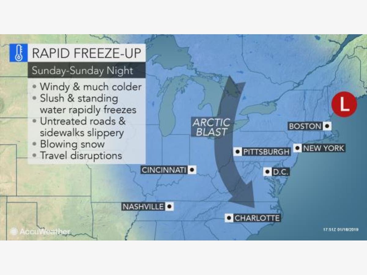
Map: AccuWeather.com.
Get more local news delivered straight to your inbox. Sign up for free Patch newsletters and alerts.