Weather
Hazardous Weather, Then Heat: Hudson Valley Weekend Weather
A weak tornado early Saturday afternoon is possible, according to the National Weather Service.

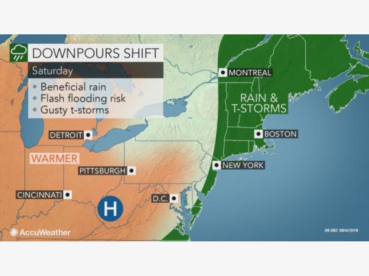
The possibility of more rainy weather is in store for the first part of the weekend in the Hudson Valley, then the heat comes in. There’s a flash flood watch in effect for the entire region until noon Saturday.
Hazardous weather outlooks for Columbia, Dutchess, Orange, Putnam, Rockland, Ulster and Westchester counties said that isolated non-severe thunderstorms are expected for Saturday afternoon.
For the lower Hudson Valley, there could be damaging winds or even a weak tornado through early Saturday afternoon.
Find out what's happening in New Rochellefor free with the latest updates from Patch.
Beginning Sunday, the summer heat comes back.
So far, only Columbia, Dutchess and Ulster counties have a hazardous weather outlook for Sunday through Tuesday, with high temperatures climbing into the 80s to low 90s. Dew points will be nearing 70, so heat advisories may be required for areas from the Capital District south to the mid-Hudson Valley.
Find out what's happening in New Rochellefor free with the latest updates from Patch.
Here the forecast from the National Weather Service for Saturday and Sunday for Westchester:
- Saturday: Showers and possibly a thunderstorm, mainly before 2pm, then a chance of showers and thunderstorms after 2pm. Some of the storms could produce gusty winds and heavy rain. High near 84. Southwest wind 6 to 8 mph. Chance of precipitation is 80%. New rainfall amounts between a half and three quarters of an inch possible.
- Saturday Night: Partly cloudy, with a low around 70. Light west wind.
- Sunday: Sunny, with a high near 90. Light and variable wind.
- Sunday Night: Mostly clear, with a low around 72. Light southwest wind.
Here is the forecast from the NWS for Saturday and Sunday for the mid-Hudson Valley:
- Saturday: Rain likely and possibly a thunderstorm before noon, then scattered showers and thunderstorms, mainly between noon and 4pm. Some of the storms could produce heavy rain. Cloudy, then gradually becoming mostly sunny, with a high near 87. West wind around 6 mph. Chance of precipitation is 70%. New rainfall amounts between a quarter and half of an inch possible.
- Saturday Night: Partly cloudy, with a low around 65. Calm wind.
- Sunday: Sunny and hot, with a high near 93. Heat index values as high as 97. Light west wind.
- Sunday Night: Mostly clear, with a low around 69. Calm wind.
Get Patch’s daily newsletters and news alerts right in your inbox.
Find and “Like” Hudson Valley Patches' Facebook Pages.
Map: AccuWeather.com.
Get more local news delivered straight to your inbox. Sign up for free Patch newsletters and alerts.