Weather
Hudson Valley Winter Weather Forecast Released for January, Early February
Forecasters released an updated winter weather forecast for the rest of January — and it may not be what you'd normally expect.

The weather may feel more like April than January in the coming weeks. But don't expect it to last.
Forecasters released an updated winter weather forecast for the rest of January, including New York — and it may not be what you'd normally expect.
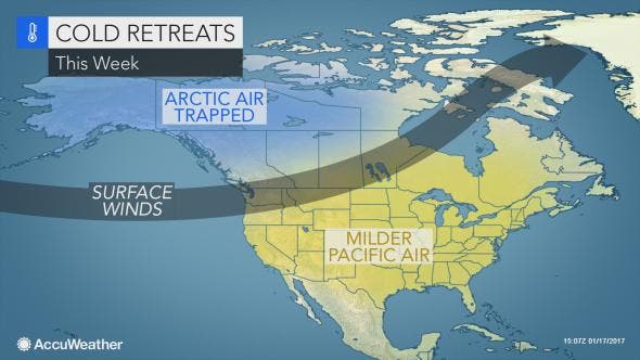
Weather is expected to be unseasonably warm over the next couple weeks as mild Pacific air travels to the Hudson Valley. Surface winds will prevent cold air — the so-called "polar vortex" — from coming down from Canada to our region.
Find out what's happening in New Rochellefor free with the latest updates from Patch.
But that's likely to change by the time February rolls around.
A central U.S. storm could signal another pattern change at the end of the month as a storm makes its way toward the Great Lakes, then Ontario, Canada, funneling colder, perhaps arctic air southward and eastward, AccuWeather Senior Long-Range Meteorologist Jack Boston said in an AccuWeather release.
Find out what's happening in New Rochellefor free with the latest updates from Patch.
That could mean "snowy conditions" in the Hudson Valley and other areas of the Northeast by the end of January and early February.
"January may end with near to below-average temperatures and a return of snowy conditions around the Great Lakes and part of the Northeast," Boston said.
The National Weather Service and The Weather Channel did say we could be looking at a wet weekend coming up across a lot of the country. A strong jet stream will combine with a strong low-pressure system, a piece of the next winter storm and moisture from the Gulf of Mexico to bring a greater threat of severe thunderstorms Saturday and Sunday in the South, according to The Weather Channel.
In the Hudson Valley, the rains are forecast to arrive here on Monday and Tuesday of next week and it could bring a substantial amount of rain, according to the National Weather Service.
We'll also see moderate temps beginning tomorrow with highs pushing near 50 degrees and continuing to be in the mid 40s to near 50 degrees into early next week. No snow is in the forecast for the area until the end of next week, according to AccuWeather.com.
Here is what the National Weather Service and AccuWeather are saying:
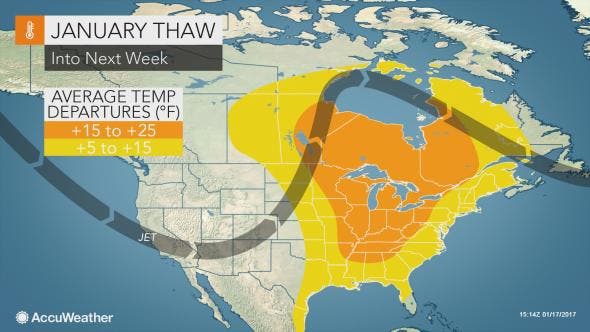
- The upcoming pattern for the remainder of the month will have some people in the South shedding winter coats, while others in the northern tier will be "changing up their outerwear on a daily basis," according to AccuWeather.
- We'll see temperatures in the 50s this week, and then we're looking at a week of above normal temperatures.
- Indeed, once chilly air and snow erode in New England, highs in the 30s, 40s and 50s will be common in New York and in the 60s and 70s in the South.
- These conditions will lead to an extended thaw over the Midwest and the mid-Atlantic.
In many parts of the nation, early January lived up to its wintry reputation, according to AccuWeather.
At one point this past week, snow was on the ground and freezing temperatures existed in every state except Florida, thanks to a snowstorm that swept from the Northwest to the Southern states and then to the coastal Northeast.
Written by Tom Davis and Brian McCready, Patch staff
Images inside the story from Accuweather.com
Get more local news delivered straight to your inbox. Sign up for free Patch newsletters and alerts.