Weather
'Significant Snowfall' Possible With Nor'easter Monday Night
Meteorologists said heavy winds could cause blizzard conditions.

After Friday’s snowfall, the Hudson Valley is experiencing a weekend with really cold temperatures but no precipitation.
That is going to change early next week with the possibility of a major nor’easter tearing through the East Coast.
AccuWeather.com meteorologist Alex Sosnowski said this was winter striking back.
Find out what's happening in New Rochellefor free with the latest updates from Patch.
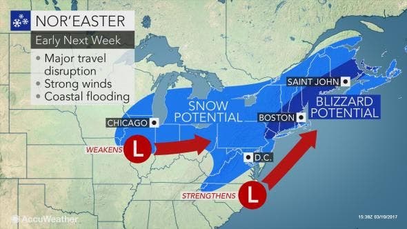
“A storm will rapidly strengthen and track within a couple of hundred miles of the East coast of the U.S. spanning Monday night to Tuesday night,” he said. “For many areas in the Northeast, this will likely be the biggest and most impactful storm of the winter.”
“A widespread snowfall of 6 inches is likely with localized amounts over 12 inches in the Northeast,” AccuWeather Senior Meteorologist Brett Anderson said.
Find out what's happening in New Rochellefor free with the latest updates from Patch.
There are a bunch of “ifs” and “maybes” built into the forecast because no definitive track for the storm has yet been determined.
The National Weather Service has issued a Hazardous Weather Outlook for the Hudson Valley that says the potential is increasing for a strong coastal storm “producing significant snowfall and strong winds Monday night into Tuesday night."
Alex Marra of Hudson Valley Weather has been monitoring the pending storm for a few days. He’s not ready to call which track the storm will take but does have some words of caution.
“In this timeframe, we are typically very cautious with our forecast, but given the high impact potential of this storm, and the incredible model consensus, it is important for us to highlight the best and worst case scenarios while also allowing you all to factor these scenarios into your plans and preparations,” he said.
From the National Weather Service:
Confidence is increasing for a strong coastal storm to bring significant snow and strong winds across the area Monday Night into Tuesday Night.
Potential exists for:
- Significant snowfall (1 ft +) with blizzard conditions
- Wind gusts of 40-50 mph along the coast
- Minor to possibly moderate coastal impacts with Tuesday high tide cycles
Uncertainty and Storm Scenarios
- There is considerable model spread in the track of the storm this far out due to a complex interaction between northern and southern jet energies.
- A storm track closer to the coast would:
Increase chance for heavy snow to mix with or change to heavy rain along the coast
Increase potential for damaging wind gusts
Increase potential for moderate coastal flooding
- A storm track farther offshore would:
Increase potential for a widespread 1+ ft snowfall with blizzard conditions
Decrease potential for moderate coastal flooding
Before then...Unseasonably cold temperatures of 15 to 20 degrees below normal will continue into Monday.
Marine Hazards (Monday Night into Tuesday Night)
- Potential for gale force gusts 34-47 kt on nearshore waters.
- Potential for storm force gusts 48-62 kt on the ocean waters south of Long Island.
- Seas could build to 15+ feet on the ocean waters Tuesday into Tuesday Night and 3 to 6 feet on Long Island Sound.
Map: AccuWeather.com.
Get more local news delivered straight to your inbox. Sign up for free Patch newsletters and alerts.