Weather
Weather Advisories, Outlooks Issued for Hudson Valley for Monday
The type of weather hazard changes depending on where you live.

With the nor’easter approaching, the National Weather Service has issued advisories and hazardous weather outlooks for the Hudson Valley.
Of course, it depends on where you live as to what you need to know and prepare for.
Southern Westchester is under a High Wind Warning from 1 a.m. Jan. 23 through 1 a.m. Jan. 24. A Coastal Flood Advisory is effect from 6 a.m. Jan. 23 until 10 a.m. Jan. 23.
Find out what's happening in New Rochellefor free with the latest updates from Patch.
The Coastal Storm Briefing is anticipating seas of 6 to 12 feet on Long Island Sound.
For Rockland and northern Westchester, there is a Wind Advisory in effect from 1 a.m. Jan. 23 through 1 a.m. Jan. 24. A Flood Watch is in effect from Monday afternoon through late Monday night.
Find out what's happening in New Rochellefor free with the latest updates from Patch.
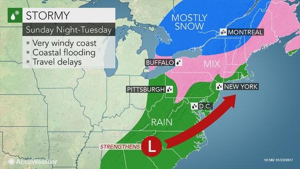
A Winter Weather Advisory is in effect from 1 p.m. Jan. 23 until 7 p.m. Jan. 24.
The forecast calls for snow, sleet and freezing rain.
The snow and sleet could be between 2 inches and 6 inches, with the higher elevations getting more.
Ice accumulation could be anywhere from a trace to one-tenth inch.
As far as the timing, the National Weather Service said the precip will begin as a mix of rain and sleet during the late morning and early afternoon.
The precipitation will transition to snow and sleet in the early evening and persist into Tuesday morning north of the mid-Hudson Valley.
All precipitation may change to a brief period of rain and freezing rain late Tuesday morning into the afternoon.
Get more local news delivered straight to your inbox. Sign up for free Patch newsletters and alerts.