Home & Garden
Work Week Weather: Rain, 60s and Fog in New Rochelle's Forecast
There's a Hazardous Weather Outlook in Westchester County this morning, and we'll let you know when to expect rain and a temperature drop.

Written by BRIAN MCCREADY (Patch Staff)
It’s mid December and of course thunderstorms are in the forecast! In another sign that winter seemingly may never come this year, the National Weather Service cautions that thunderstorms are possible late Monday and early Tuesday.
Additionally, there’s a Hazardous Weather Outlook until noon today in Westchester County for dense fog.
Find out what's happening in New Rochellefor free with the latest updates from Patch.
And of course temperatures will be near 60 on both Monday and Tuesday, too.
“After sunset [Monday]… the rain quickly descends upon the Hudson Valley, and we’ll see a potentially wet commute, and damp evening hours,” writes Bill Potter of Hudson Valley Weather. “We’re not expecting a significant rain (less than a half inch)… but just something to keep in mind if you have evening plans. The rain moves out after midnight… and with the passage of the front, the wind shifts out of the west/northwest, and really begins to crank up. A very blustery day ahead on Tuesday… but still mild for December.”
Find out what's happening in New Rochellefor free with the latest updates from Patch.
The work week forecast once again features above normal temperatures but the upcoming weekend shows that things will begin to cool down and feel more seasonal.
But before we get there here is the latest work week forecast in detail via the NWS:
Today: Cloudy. Widespread dense fog early this morning. A chance of showers this afternoon. Visibility one quarter mile or less at times early this morning. Highs in the lower 60s. South winds 5 to 10 mph. Chance of rain 50 percent.
Tonight: Showers with isolated thunderstorms in the evening...then a slight chance of showers after midnight. Lows in the lower 50s. South winds 5 to 10 mph...becoming southwest after midnight. Gusts up to 20 mph. Chance of rain 90 percent.
Tuesday: Mostly sunny and breezy. Highs in the lower 60s. Northwest winds 15 to 20 mph with gusts up to 30 mph.
Tuesday Night: Mostly clear. Lows in the lower 40s. Northwest winds 10 to 15 mph.
Wednesday: Sunny. Highs in the lower 50s. North winds 5 to 10 mph...becoming east in the afternoon.
Wednesday Night: Partly cloudy in the evening...then becoming mostly cloudy. Lows in the mid 40s.
Thursday: Rain likely in the afternoon. Highs in the mid 50s. Chance of rain 70 percent.
Thursday Night: Mostly cloudy. Rain likely...mainly in the evening. Lows in the mid 40s. Chance of rain 60 percent.
Friday: Partly sunny. A chance of rain in the morning...then a chance of showers in the afternoon. Highs around 50. Chance of rain 30 percent.
Friday Night: Partly cloudy. Lows in the mid 30s.
Saturday and Sunday: Temperatures become more seasonal with highs in the low 40s, but mostly sunny skies are expected.
Patch Editor Alfred Branch contributed to this report.
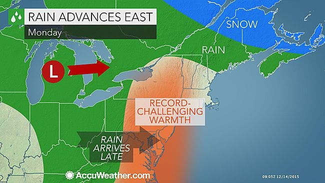
Map via AccuWeather.com
Get more local news delivered straight to your inbox. Sign up for free Patch newsletters and alerts.