Weather
Hudson Valley Forecast: Bomb Cyclone Headed Here For The Weekend
A hazardous outlook has been issued for the mid-Hudson for strong winds and rain, though serious snow is only expected upstate.


SEE FRIDAY NIGHT'S FORECAST: Snow Estimates, Timing Revised For Winter Storm In Hudson Valley
SEE:
- 2 Hudson Valley St. Patrick's Parades Rescheduled
- FRIDAY MORNING'S FORECAST: Bomb Cyclone Races Low Pressure Toward The Hudson Valley
HUDSON VALLEY, NY, Thursday — A massive mid-March winter storm could bring snow and sleet along with strong winds, heavy rain and plummeting temperatures as the weekend starts, the National Weather Service said.
Find out what's happening in Nyack-Piermontfor free with the latest updates from Patch.
A hazardous outlook has been issued for the mid-Hudson Valley, eastern Catskills, Taconic and Capital regions. However, uncertainty remains about the storm`s exact path, the NWS said.
"ANY MINOR CHANGES IN TRACK WILL HAVE SIGNIFICANT IMPACTS ON THE FORECASTS ACROSS SOUTHERN AND EASTERN PARTS OF THE REGION," Alex Marra and Bill Potter emphasized on the Hudson Valley Weather Facebook page.
Find out what's happening in Nyack-Piermontfor free with the latest updates from Patch.
It looks as if the Hudson Valley once again will be on the warm side of a winter storm that dumps 6-12 inches upstate. This one is expected to intensify enough to become a bomb cyclone.
A storm undergoes bombogenesis when the atmospheric pressure at its center plummets by 0.71 of an inch of mercury or more within 24 hours. This particular storm will likely far exceed that criteria with the central pressure forecast to plummet close to 1 inch of mercury from Friday evening to Saturday evening, said Alex Sosnowski, AccuWeather senior meteorologist.
Light snow is expected in Orange County while Rockland should see some sleet and snow accumulation. Rain is in the forecast for Putnam and Westchester counties.
Though the heaviest rain could last only a few hours in the Interstate-95 corridor, it could be heavy enough to lead to street and highway flooding from late Friday night to Saturday," Sosnowski said. "Flight delays and cancellations are anticipated and could result in ripple-effect impacts across the country."
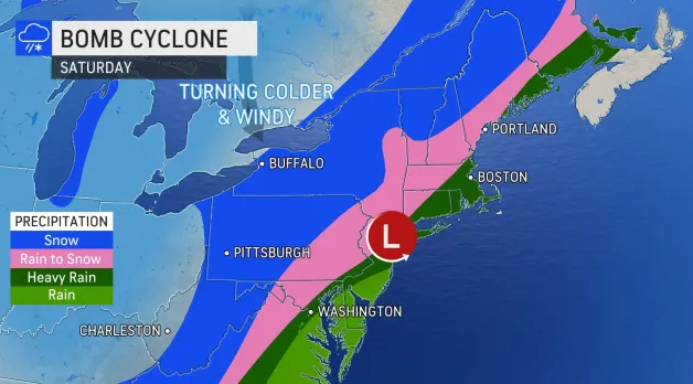
In Dutchess and Ulster, precipitation is expected to change over to snow during the day on Saturday. Heavy snowfall, high winds and reduced visibility could make for difficult driving conditions at times.
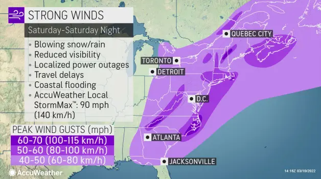
Across the region, gusty winds are also possible for Saturday afternoon into Saturday night. Strong winds could lead to power outages.
Everyone will be affected by the aftermath as well.
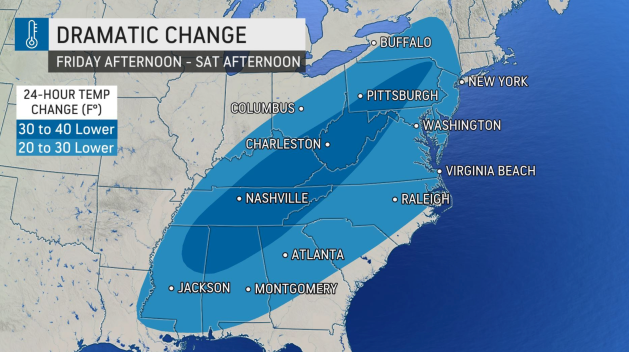
As the storm moves off the East Coast, unseasonably cold air will filter from the Plains across the east along with strong winds. Much colder air will spread across the Southeast and Mid-Atlantic in the storm's wake. Temperatures are forecast to plunge into the teens.
- Friday - Patchy freezing fog before 7am. Mostly sunny, with a high near 52. Calm wind becoming south 5 to 7 mph in the afternoon.
- Friday Night - Rain likely, mainly after 2am. Cloudy, with a low around 39. South wind around 6 mph becoming calm after midnight. Chance of precipitation is 70%. New precipitation amounts between a tenth and quarter of an inch possible.
- Saturday - Rain before 2pm, then rain, snow, and sleet between 2pm and 3pm, then snow after 3pm. Temperature rising to near 45 by 10am, then falling to around 33 during the remainder of the day. Wind chill values between 20 and 30. Breezy, with a northeast wind 5 to 10 mph becoming northwest 15 to 20 mph in the afternoon. Winds could gust as high as 36 mph. Chance of precipitation is 100%. New snow and sleet accumulation of less than one inch possible.
- Saturday Night - A 30 percent chance of snow, mainly before 7pm. Cloudy, then gradually becoming partly cloudy, with a low around 18. West wind 16 to 18 mph, with gusts as high as 40 mph.
- Sunday - Mostly sunny, with a high near 36.
- Sunday Night - Partly cloudy, with a low around 27.
- Monday - Mostly sunny, with a high near 53.
- Monday Night - Partly cloudy, with a low around 37.
>>SEE FRIDAY MORNING'S REVISED FORECAST: Bomb Cyclone Races Low Pressure Toward The Hudson Valley
>>This is a developing weather story. Keep checking back with Patch for updates.
Get more local news delivered straight to your inbox. Sign up for free Patch newsletters and alerts.

