Weather
Bomb Cyclone Races Low Pressure Toward The Hudson Valley
When and how they meet will determine what kind of precipitation will prevail. Here's the latest.


FRIDAY EVENING UPDATES:
- Snow Estimates, Timing Revised For Winter Storm In Hudson Valley
- 2 Hudson Valley St. Patrick's Parades Rescheduled
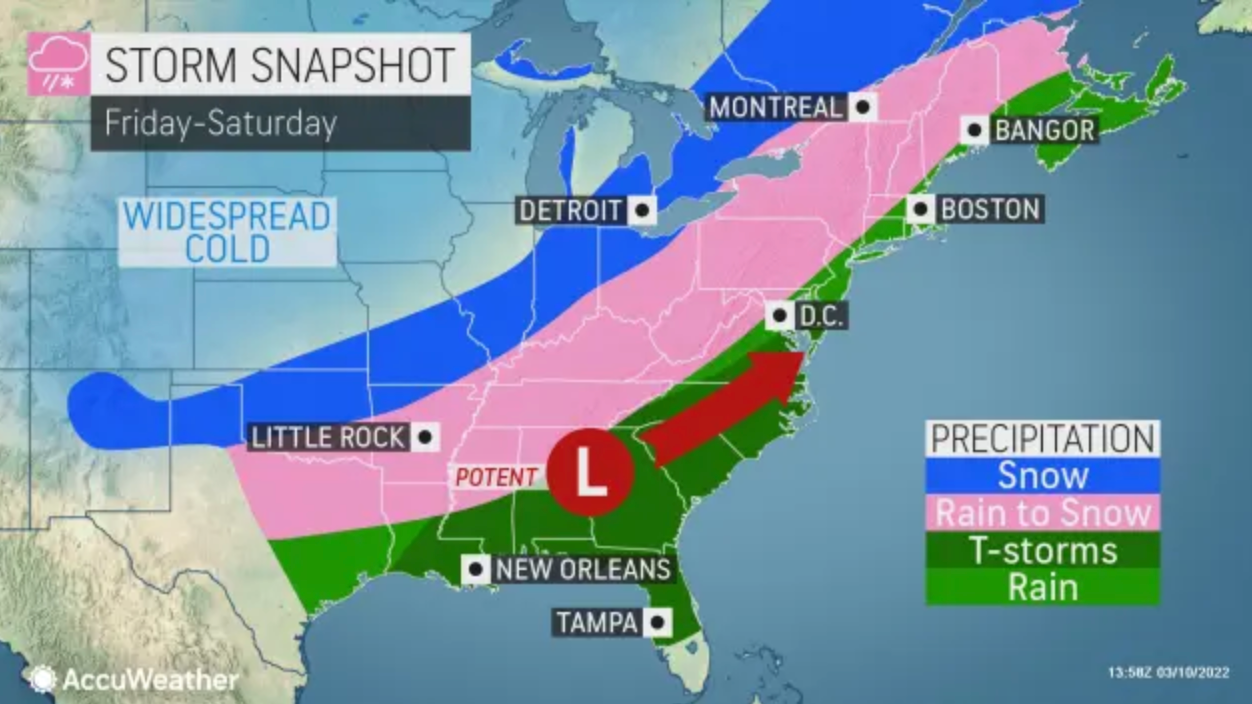
HUDSON VALLEY, NY, Friday morning — The storm that's expected to intensify into a bomb cyclone as it hits the region Saturday will bring rain, sleet and snow, high winds and low temperatures. The National Weather Service has issued winter weather advisories and a gale warning for parts of the Hudson Valley.
The storm's path from the Gulf Coast — and the speed and track of a low-pressure system also headed our way — will determine what kind of precipitation will prevail and whether what we get will freeze.
Find out what's happening in Ossining-Croton-On-Hudsonfor free with the latest updates from Patch.
"The position and timing of each of the features could mean the difference between a soaking rain, and a heavy late-season snow," said Alex Marra and Bill Potter of Hudson Valley Weather on Facebook.
The NWS put three "if" clauses in its storm report:
Find out what's happening in Ossining-Croton-On-Hudsonfor free with the latest updates from Patch.
- If low pressure moves farther east, then snowfall totals could increase across the entire area.
- If temperatures fall quickly enough, freezing road conditions would lead to hazardous travel across a larger portion of the area.
- If the storm intensifies more than forecast, then wind gusts could exceed 45 mph across the entire area.
The storm will start as rain after midnight, then change to rain, rain and sleet, rain, sleet and snow, or snow. Temperatures will fall into the 20s in the afternoon.
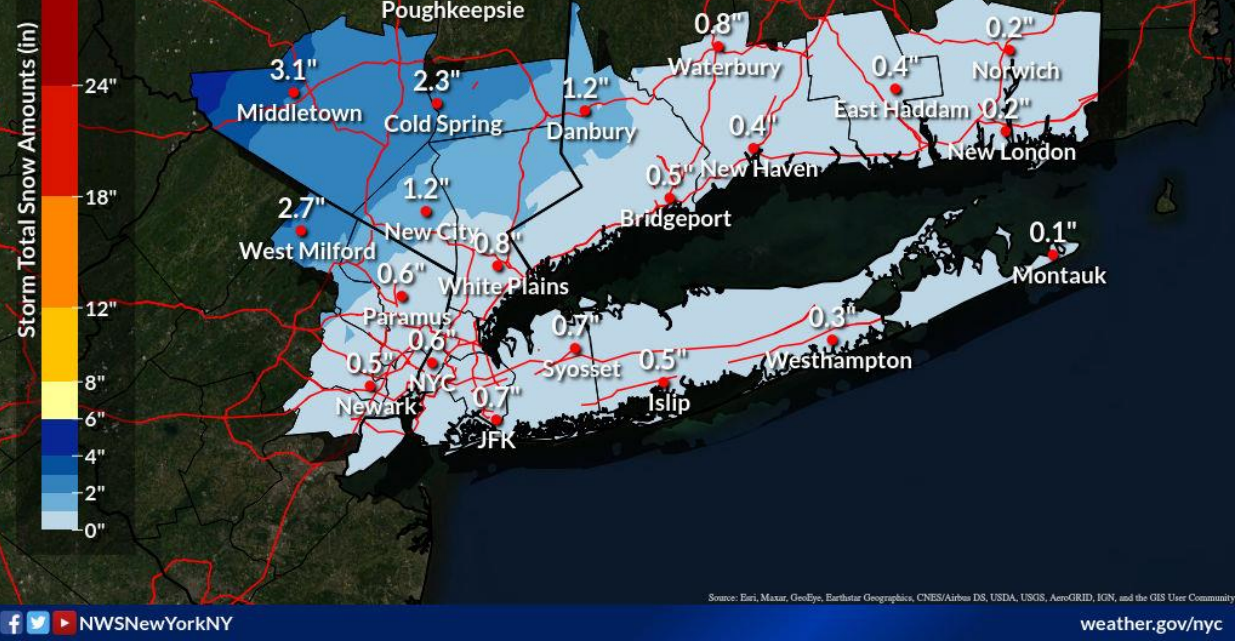
Dutchess, Orange and Ulster counties are under winter weather advisories from 7 a.m. to 7 p.m. Saturday. Dutchess and Ulster could receive 2 to 5 inches of snow, the NWS predicted, and Orange County could receive 2-4 inches of snow. In addition, standing water on roads could freeze, resulting in difficult travel conditions.
The National Weather Service predicts Putnam County will receive 1-3 inches of snow. Westchester County will get less than an inch. If low pressure moves farther east, then snowfall totals could increase.
Hudson Valley Weather said the Catskills were most likely to see significant snow: 6-12 inches.
"In order for snow, we need the front to reach our area before the moisture from the advancing low pressure reaches us. So exactly when that cold air arrives vs exactly how much rain falls before the changeover to snow ... is critical to the details of the forecast," Hudson Valley Weather said. "Regardless of the details, this storm is likely to have considerable impact to your Saturday plans."
The storm is expected to rapidly strengthen into a bomb cyclone along the Eastern Seaboard, said Alex Sosnowski, AccuWeather senior meteorologist.
A storm becomes a bomb cyclone, or undergoes bombogenesis, when the atmospheric pressure at the center of the storm plummets by 0.71 of an inch of mercury or more within 24 hours. This particular storm will likely far exceed that criteria, with the central pressure forecast to plummet close to 1 inch of mercury from Friday evening to Saturday evening.
"On the storm's warm side, which will generally encompass much of the Atlantic Seaboard, rain and thunderstorms are in store," he said. The rain could be heavy enough to lead to street and highway flooding from late Friday night to Saturday. Thunderstorms are not expected north of New York City.
On the storm's cold side, across central and northern New York, this is the type of setup that can lead to cars sliding off roads, major pileup accidents or motorists stranded on highways, Sosnowski said.
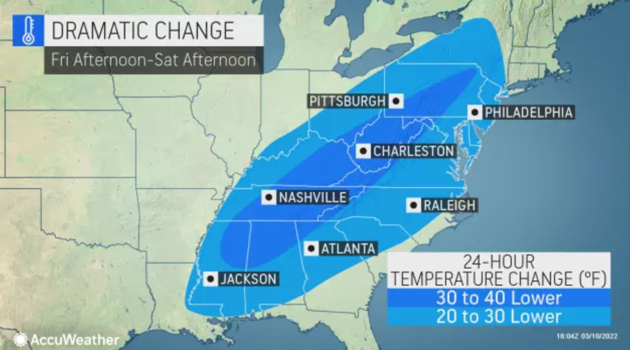
Forecasters are confident that wind chills will be in the single digits by early Sunday morning throughout the region.
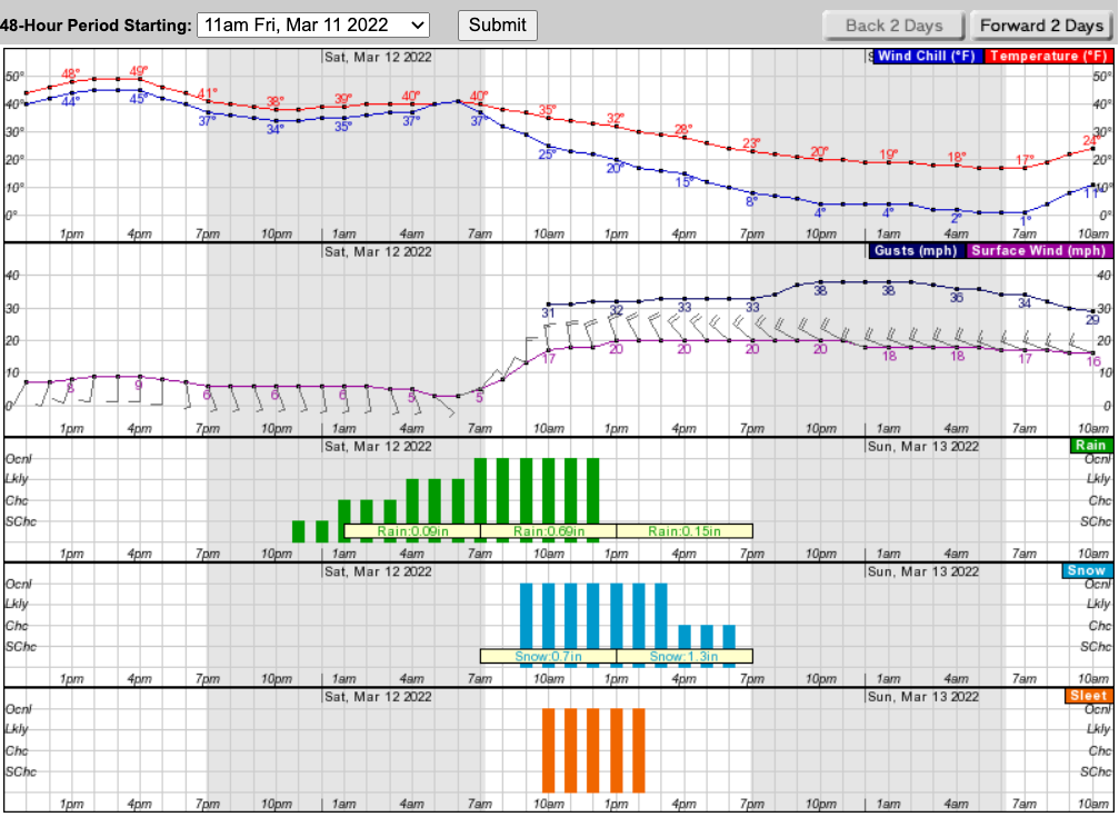
Here's a look at the next 48 hours based on Putnam County:
Get more local news delivered straight to your inbox. Sign up for free Patch newsletters and alerts.


