Home & Garden
Weather Update: Temps Will Plummet After the St. Patrick's Day Parade
Arctic air, and maybe some snow toward the end of the week, will usher in a chilly start to spring in Nyack and Piermont.

It’ll be in the 50s and windy for local groups marching today in New York City, and the rain will taper off. But after this afternoon, wave goodbye for a while to milder weather.
According to AccuWeather.com’s hourly forecast, temperatures in Piermont and Nyack will drop below freezing around midnight tonight and just stay around there.
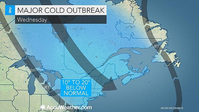
“Wednesday continues to look very, very cold,” said Bill Potter of Hudson Valley Weather. “Most of the Hudson Valley will struggle to reach the 32° mark on Wednesday. The average high for Wednesday is 49°… so that is almost 20 degrees below average. That is some brutal cold… and what’s worse… check out the wind chills that are projected for Wednesday afternoon (upper teens to the low 20s)!”
Find out what's happening in Nyack-Piermontfor free with the latest updates from Patch.
If that’s not enough, by Friday, a coastal storm is predicted, possibly bringing some snow.
Saturday, the first day of spring, will return us to the high 40s.
Find out what's happening in Nyack-Piermontfor free with the latest updates from Patch.
Still, additional waves of chilly air will follow through the end of the month and into the first part of April, said Alex Sosnowski, AccuWeather.com senior meteorologist.
The National Weather Service has a Hazardous Weather Outlook in place warning people of local flooding due to snowmelt and ice jams:
Here’s the 5-day NWS forecast for Rockland County:
Today--Cloudy with rain likely this morning...then partly sunny this afternoon. Windy with highs around 50. Southwest winds 10 to 15 mph...becoming northwest 15 to 25 mph with gusts up to 40 mph this afternoon. Chance of rain 70 percent.
Tonight--Mostly clear in the evening...then becoming partly cloudy. Breezy and cooler with lows in the lower 20s. Northwest winds 15 to 20 mph with gusts up to 40 mph.
Wednesday--Mostly sunny and breezy. Highs in the upper 30s. Northwest winds 15 to 20 mph with gusts up to 35 mph.
Wednesday Night--Mostly clear. Lows around 19. Northwest winds 10 to 15 mph. Gusts up to 25 mph in the evening.
Thursday--Sunny. Highs in the upper 30s. Northwest winds 5 to 10 mph.
Thursday Night--Partly cloudy in the evening...then becoming mostly cloudy. Lows in the mid 20s.
Friday--Mostly cloudy. A chance of snow in the morning...then a chance of rain and snow in the afternoon. Highs in the lower 40s. Chance of precipitation 50 percent.
Friday Night--Mostly cloudy. A chance of rain and snow in the evening. Lows in the upper 20s. Chance of precipitation 50 percent.
Saturday--Mostly sunny. Highs in the upper 40s.
Saturday Night--Mostly cloudy in the evening...then becoming partly cloudy. Lows around 30.
MAP: AccuWeather.com
Get more local news delivered straight to your inbox. Sign up for free Patch newsletters and alerts.

