Weather
Weekend Wind Chill, Snowfall Estimates: HV Hazardous Outlook
After after a blast of Arctic air and "harsh" conditions Saturday, parts of the region could get 6 or more inches of snow Sunday.

HUDSON VALLEY, NY — First we're going to freeze, then we're going to have to dig out. A hazardous outlook has already been issued for Orange and Putnam counties for the "extremely rare" storm the rest of the Hudson Valley will also be getting this weekend.
In the statement, the National Weather Service said "A strong storm system will move up from the south and bring snow, and then possibly mixing with rain Sunday night into Monday morning. There is the possibility of 6 or more inches of snow."
But first an Arctic cold front out of Canada will sweep into the Northeast on Friday, setting the stage for a bitter cold night and start to the weekend. With gusty winds, conditions "will be quite harsh," said Alex Marra and Bill Potter of Hudson Valley Weather.
Find out what's happening in Nyack-Piermontfor free with the latest updates from Patch.
Wind chills overnight Friday could go as low as 20 below zero.
On Saturday, temperatures will be in the teens across the Hudson Valley and the wind will continue gusty; temps will drop to single digits overnight with wind chill values again below zero.
Find out what's happening in Nyack-Piermontfor free with the latest updates from Patch.
On Sunday, daytime highs are expected to be in the 20s — but then rise after midnight as the storm hits.
This storm's path — diving deep into the South from western Canada and then pivoting to drive up the East Coast — is "extremely rare," said Alex Sosnowski, AccuWeather senior meteorologist.
After pummeling the Midwest and the South, it is expected to trigger heavy snow, ice and rain throughout the mid-Atlantic, central Appalachians and New England Sunday into Monday. What kind of precipitation will predominate will depend on the exact track — a shift of less than 50 miles will make the difference between all snow and a wintry mix in the Hudson Valley.
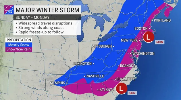
Plus, because the storm is expected to bring snow, sleet and even flooding rain to most of the eastern United States, disruptions to travel, shipping, and COVID-19 testing are anticipated, Sosnowski said.
Get more local news delivered straight to your inbox. Sign up for free Patch newsletters and alerts.