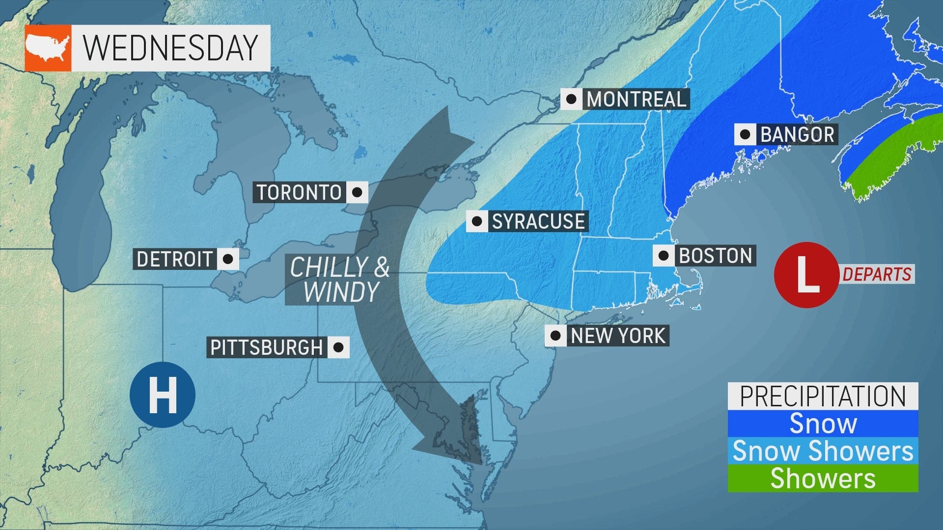
Weather
Heavy Rain, Wet Snow, Gusty Winds: Nor'easter Hits The HV
The storm could bring 2 inches to 2 feet to parts of the Hudson Valley with 2-4 ft waves possible on the Sound Shore over the next 48 hours.

HUDSON VALLEY, NY — A winter storm expected to last for two days is bringing drenching rain, heavy wet snow, high winds and coastal flooding to the region. It is expected to make travel difficult and cause scattered damage to tree limbs and power lines, meteorologists warned.
The biggest uncertainty is in how quickly the rain will turn to snow. "If the change over to snow is faster, more snow. If the change over is slower, less snow," the folks at Hudson Valley Weather explained.
SEE ALSO: HV Nor'easter: State Restricts Truck Traffic, Deploys Resources
Find out what's happening in Ossining-Croton-On-Hudsonfor free with the latest updates from Patch.
Winter Storm Warnings are now in effect for Dutchess, Orange, Putnam and Ulster counties, while Rockland and northern Westchester remain under a winter weather advisory.
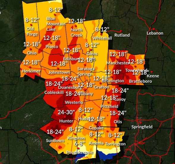
- Western Ulster County: The storm warning goes into effect at 2 p.m. Total snow accumulations of 10 to 20 inches with 2 to 3 feet across the higher terrain of the eastern Catskills. Winds gusting as high as 45 mph.
- Dutchess and eastern Ulster: The storm warning is in effect from 8 p.m. Monday to 8 a.m. Wednesday. Total snow accumulations of to 6 to 12 inches. Travel could be very difficult. The weight of the heavy wet snow on tree branches will likely result in power outages. Snowfall rates in excess of 1 inch per hour are possible.
- Orange and Putnam counties: The NWS predicts total snow accumulations of 4 to 12 inches, with the higher amounts at elevations above 750 feet "where power outages are possible due to heavy wet snow."
- Rockland and northern Westchester: The advisory extends from midnight Monday to 6 a.m. Wednesday. Total snow accumulations of 2 to 5 inches. Winds gusting as high as 40 mph. Elevations above 500 ft will have accumulations closer to 5 and 7 inches. This is where power outages are possible due to heavy wet snow.
- Southern Westchester: Expect up to 1.5 feet of inundation above ground level in low-lying, vulnerable areas. Breaking 2-4 foot waves will result in beach erosion and flooding. Waves splashing over bulkheads and seawalls may locally exacerbate flooding of vulnerable shoreline roadways and structures. Heavy rain during the times of high tide will likely exacerbate street flooding.
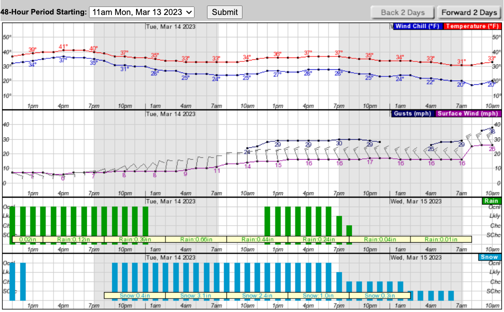
For interior portions of the lower Hudson Valley, snowfall rates of 1-2 inches per hour are likely overnight into Tuesday morning.
Find out what's happening in Ossining-Croton-On-Hudsonfor free with the latest updates from Patch.
Flood impacts may be locally increased due to the combination of rain, snow melt, and snow-clogged drains.
Travel could be very difficult. "If you must travel, keep an extra flashlight, food, and water in your vehicle in case of an emergency," the NWS urged. The hazardous conditions could affect the Tuesday morning and evening commutes.
The expected snowfall:
"Forecasters say that tides will have the potential to rise 2-3 feet above the historical average for mid-March, particularly during times of high tide from Monday to Tuesday," said Alyssa Smithmyer, AccuWeather Meteorologist.
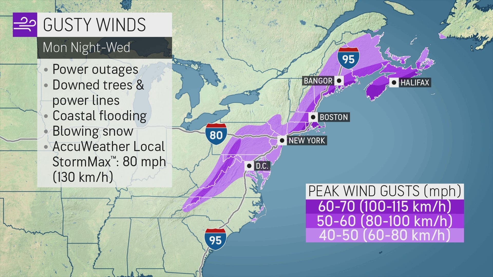
Winds will rise as the storm moves through. "Gusts can reach speeds of 50-60 mph along the spine of the Appalachians, parts of New Jersey and southeastern New York," she said.
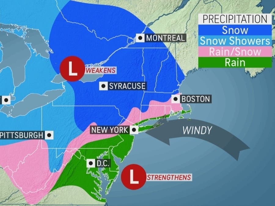
Two components are joining forces, one from the upper Midwest into New York and the other up the Atlantic Coast. The latter has the potential to develop into what forecasters call a bomb cyclone.
"Temperatures in New York City on Tuesday can climb to a high of 42 degrees Fahrenheit, but that daily maximum will likely not occur in the afternoon as it typically does," Smithmyer said. "The daytime high in the city could be recorded during the early morning hours and crash throughout the day as rain mixes with snow. The variability of the track of the storm can have a significant impact on conditions in northern New Jersey and southeastern New York."
The size and potency of the storm means transportation hubs could face challenging weather conditions for days. She urged travelers to call ahead to check on the status of their flights.
Utility companies in the Hudson Valley began prepping for the storm last week.
"A snowstorm, featuring high water content as this storm does, could pose a significant threat to electric service because of the increased risk its weight contributes to downing trees, tree limbs and overhead electric lines — all of which could interfere with the safe, reliable delivery of electric service," said Mike Donovan, a spokesman for Orange & Rockland Utilities.
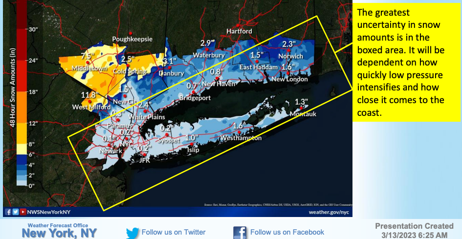
Here's a look at the next 48 hours for Poughkeepsie:
Check back with Patch for updates.
Get more local news delivered straight to your inbox. Sign up for free Patch newsletters and alerts.


