Weather
Hudson Valley Forecast: More Heavy Rain, Flooding Possible
The threat is elevated due to saturated ground, high water tables, and high stream and river levels from Henri and Ida, says the NWS.


HUDSON VALLEY, NY — More flooding is possible Wednesday into Thursday in the Hudson Valley as many residents and businesses are struggling to clean up after post-hurricane Ida.
The National Weather Service has issued a hazardous weather outlook for mid-week in the region, as a cold front may bring a period of heavy rainfall and thunderstorms to the Hudson Valley late Wednesday into early Thursday.
The NWS warns the threat of flooding is elevated due to the saturated ground, high water tables, and high stream and river levels from tropical storms Henri and Ida.
Find out what's happening in Ossining-Croton-On-Hudsonfor free with the latest updates from Patch.
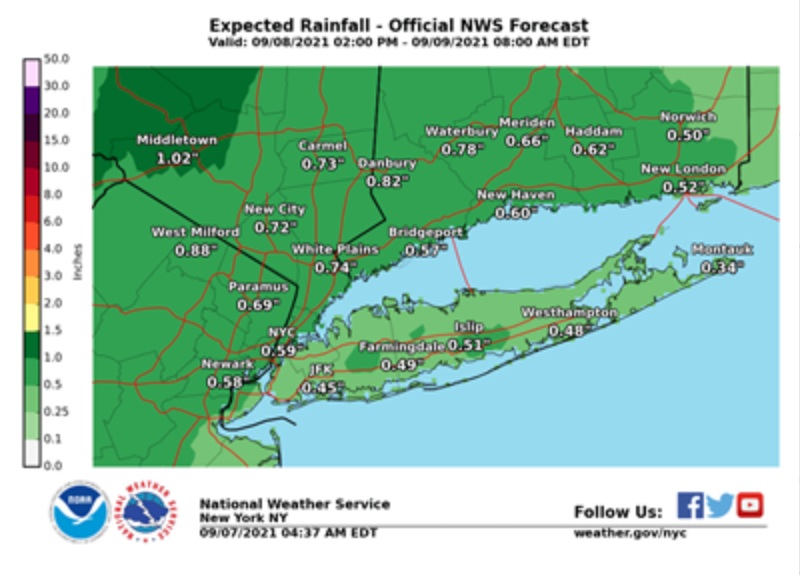
For Orange, Putnam, Rockland and Westchester counties, as well as southern Connecticut and northeast New Jersey, there is a marginal to slight risk of excessive rainfall/flash flooding.
For Dutchess and Ulster, areas of poor drainage and urban flooding could be affected.
Find out what's happening in Ossining-Croton-On-Hudsonfor free with the latest updates from Patch.
Only 1/2 inch to 1 inch of rain is probable, and the worst-case scenario is just 1-2 inches (which used to sound like a lot, but Henri dumped 6 inches across the region and Ida inundated the region and killed five people with almost 9 inches of rain.)
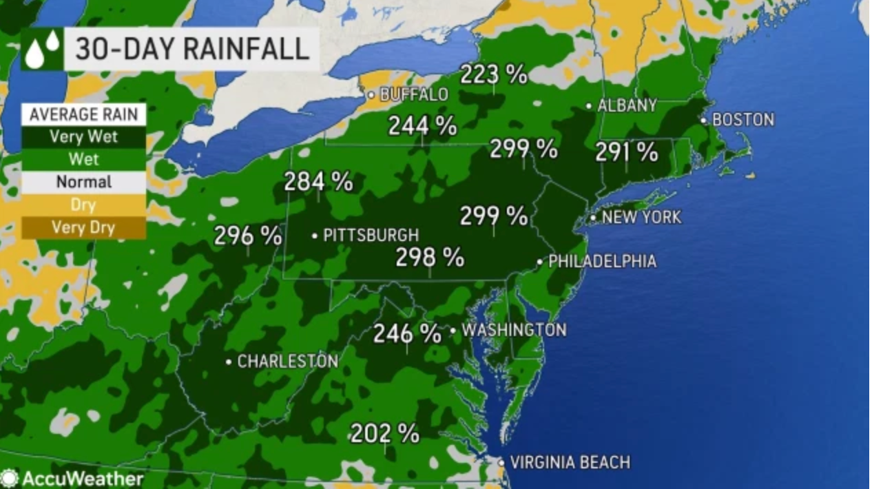
"The same cold front that will produce severe weather across the Great Lakes on Tuesday will shift into the Northeast on Wednesday and deliver rounds of stormy weather," said Courtney Travis, AccuWeather senior meteorologist. "Since Aug. 1, New York City has recorded more than 300 percent of the city's normal rainfall."
Here's the five-day forecast for the Hudson Valley from the National Weather Service:
- Tuesday - Sunny, with a high near 78. Light west wind.
- Tuesday night - Mostly clear, with a low around 63. Calm wind.
- Wednesday - A chance of showers, then showers and thunderstorms likely after 2pm. Mostly sunny, with a high near 81. South wind 5 to 10 mph, with gusts as high as 21 mph. Chance of precipitation is 60%. New rainfall amounts of less than a tenth of an inch, except higher amounts possible in thunderstorms.
- Wednesday Night - Showers and thunderstorms before 2am, then a chance of showers. Some of the storms could produce heavy rain. Low around 65. South wind 5 to 7 mph becoming calm after midnight. Chance of precipitation is 80%. New rainfall amounts between a half and three quarters of an inch possible.
- Thursday - A 30 percent chance of showers, mainly before 8am. Partly sunny, with a high near 76. Light northwest wind.
- Thursday Night - Partly cloudy, with a low around 57.
- Friday - Sunny, with a high near 74.
- Friday Night - Mostly clear, with a low around 56.
- Saturday - Sunny, with a high near 77.
- Saturday Night - Mostly clear, with a low around 60.
Get more local news delivered straight to your inbox. Sign up for free Patch newsletters and alerts.