Home & Garden
On the Edge of the Storm: Weekend Weather for Pearl River
Forecasts still tracking storm's path closely -- a shift of 50 miles would change the impact on the lower Hudson Valley Friday into Sunday.

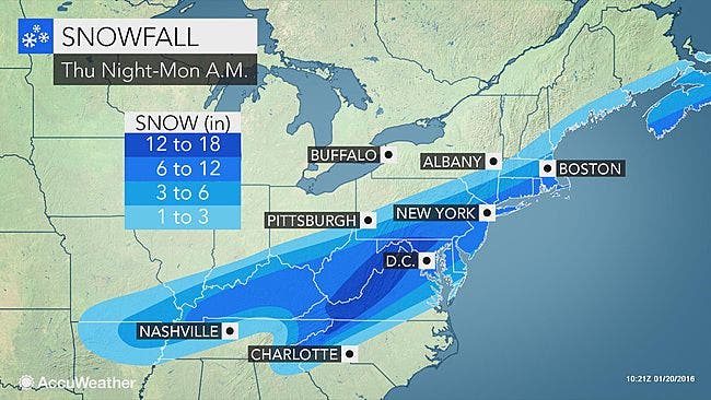
Meteorologists think they have a better handle now on the direction this big storm is taking: and states to our south are expected to take the brunt of it, dumping up to two feet of snow from D.C. to Philadelphia.
“A minimal brushing or near miss are both very real options for our region at this point in time, the probability of a low impact storm currently outweighs a major impact,” said Alex Marra of Hudson Valley Weather.
Want hour to hour info: Click here for Pearl River’s in-depth weather forecast.
Find out what's happening in Pearl Riverfor free with the latest updates from Patch.
The National Weather Service updated its Hazardous Weather Outlook for Putnam, Rockland and northern Westchester.
It says simply:
Find out what's happening in Pearl Riverfor free with the latest updates from Patch.
THURSDAY THROUGH TUESDAY. A MAJOR WINTER STORM IS POSSIBLE FRIDAY NIGHT INTO SUNDAY. THIS STORM COULD PRODUCE HEAVY SNOW AND STRONG WINDS.
That could mean anywhere from 3-12 inches of snow in the lower Hudson Valley.
For southern Westchester, flooding is also a concern.
“The exact track of the storm will hold the key,” Accuweather meteorologist Alex Sosnowski said. “The heavy snow with the storm is likely to have a fairly sharp northern edge. At this time, the northern edge is most likely to extend from southern Ohio to southern New England. A distance of less than 100 miles could bring snowfall ranging from an inch or less to more than a foot.”
The storm is expected to cause scores of flight delays and cancellations during Friday into Saturday, and periods of difficult travel for motorists.
MAP: accuweather.com
Get more local news delivered straight to your inbox. Sign up for free Patch newsletters and alerts.