Weather
Rain, Wet Snow, Icy Commute In The Hudson Valley
Hazardous outlooks have been issued for the Hudson Valley. Here's an hour-by-hour look at what's in store.

HUDSON VALLEY, NY — Hazardous weather outlooks have been issued by the National Weather Service for what the good folks at Hudson Valley Weather are calling "winter weather whiplash." Rain showers all day Tuesday will change to wet snow and, with the temperatures plummeting, create icy road conditions in the region on Wednesday morning.
The National Weather Service also predicts a possible snow accumulation of 1 to 3 inches for Westchester, Rockland, Putnam, Orange, Dutchess and Ulster counties.
"So we’ve got a wild weather ride over the next 24 hours, and even as of this post… it may all come down to a bit of luck, in determining whether we see a slushy coating, or 2 or 3 inches of wet snow tonight," said Alex Marra and Bill Potter of HVW.
Find out what's happening in Peekskill-Cortlandtfor free with the latest updates from Patch.
As usual, the devil is in the details. "The band of snow that develops is likely to be 100 to 200 miles wide, and develop at the same time as rain is changing to wet snow. The position of the boundary at that time will determine if the snow falls in the Hudson Valley, or just to our SE," they said.
The National Weather Service has issued a winter weather advisory for Westchester County for 3-11 a.m. Wednesday.
Find out what's happening in Peekskill-Cortlandtfor free with the latest updates from Patch.
- WHAT...Snow. Total snow accumulations around two inches
- WHERE...Southern Connecticut. In New York, New York City, Long Island and Westchester. In New Jersey, Eastern Bergen, Eastern Essex, Eastern Union and Hudson.
- IMPACTS...The hazardous conditions will impact the morning commute. Plan on slippery road conditions and reduced visibilities.
For Orange, Putnam and Rockland counties, the NWS has issued a hazardous weather outlook.
A period of light accumulating snow is expected early Wednesday morning which may impact portions of the morning commute. Hazardous travel conditions are possible.
There's a hazardous outlook for Dutchess and Ulster counties, but it's for a completely different weather issue:
Mild temperatures allowing for snow melt and periods of rain today will continue to result in rises on rivers and streams. Although widespread flooding is not expected at this time, some rivers may reach minor flood stage. Some minor nuisance flooding is also possible in urban and flood prone areas, especially where snow banks block storm drains.
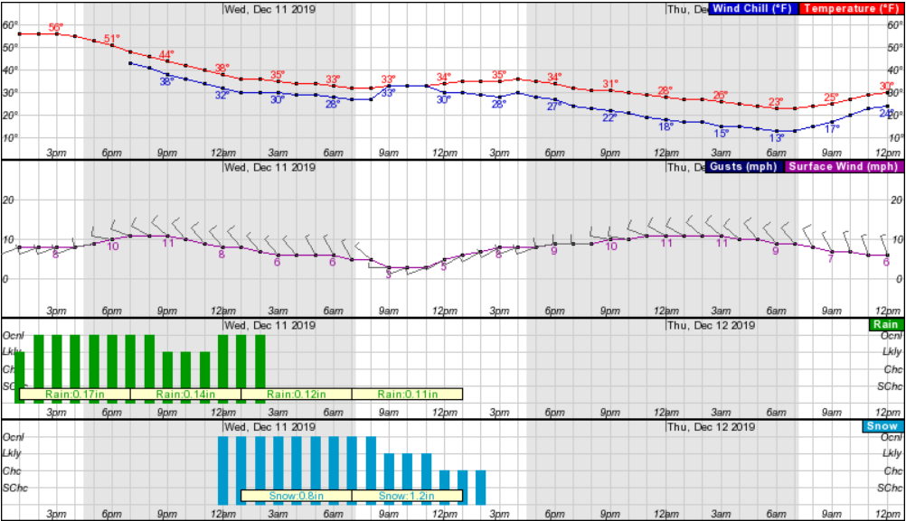
Here's a look at the hour-by-hour forecast from the NWS:
Get more local news delivered straight to your inbox. Sign up for free Patch newsletters and alerts.