Weather
Snow, Rain Aim At Hudson Valley Commute: Update
A hazardous weather outlook has been updated for the mid-Hudson. Here's the latest on the precipitation and the cold blasting behind it.

UPDATE 7AM Tuesday — Slowly moving into the Hudson Valley, cold air is pushing warm air out and the faster that happens the more precipitation is likely. A light rain and wintry mix will slowly spread from the northwest to the southeast as temperatures fall.
"Crashing temps will result in refreeze and areas of black ice through the evening into the overnight," said Alex Marra and Bill Potter of Hudson Valley Weather.
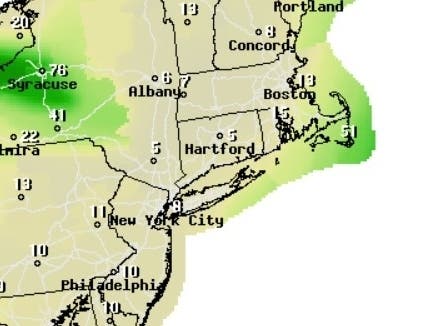
UPDATE 4:12PM MONDAY — Rain and snow are likely early Tuesday morning, becoming all snow, then gradually ending. Snow accumulations of less than an inch are possible in the lower Hudson Valley, northeastern New Jersey, and portions of southwestern Connecticut, the National Weather Service said in its afternoon update.
Find out what's happening in Peekskill-Cortlandtfor free with the latest updates from Patch.
The NWS updated its hazardous weather outlook for Dutchess and Ulster counties: Light accumulations of snow or sleet are possible late Monday and early Tuesday morning. Falling temperatures could lead to icing and hazardous travel conditions for the Tuesday morning commute. Unseasonably and potentially record cold temperatures are expected Tuesday through Thursday. High temperatures are expected to remain near or below freezing with overnight lows in the single digits or teens.
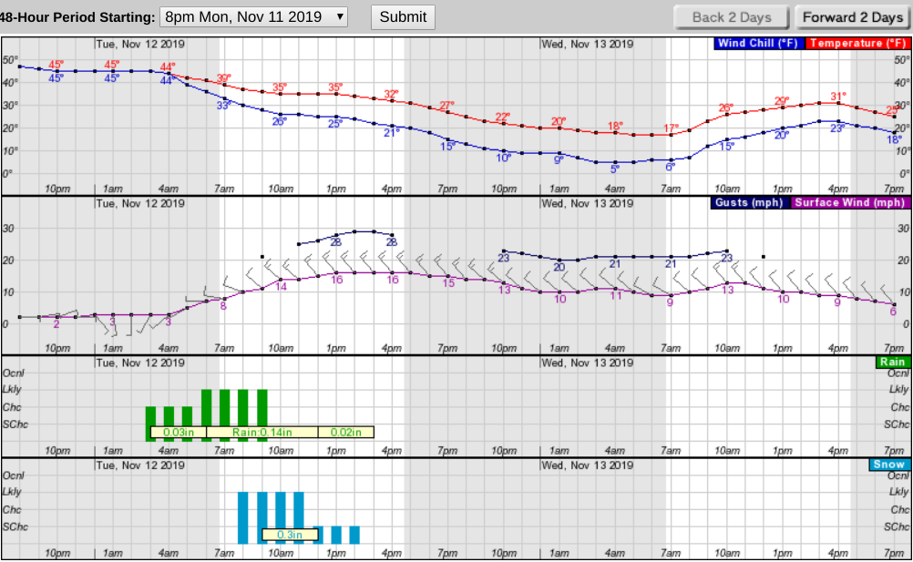
Early Tuesday morning, highs will range from the upper 40s in New York City down to the lower 40s in the Hudson Valley before the cold front passage, after which lows will plummet into the lower teens in the Hudson Valley while remaining in the lower 20s in NYC.
Find out what's happening in Peekskill-Cortlandtfor free with the latest updates from Patch.
Winds will reach up to 20 mph with gusts as high as 30 mph, bringing wind chill values down to between 0 and 10.
Rain that will change to snow for some and a wintry mix for others is expected to start Monday night as a new wave of Arctic air crosses the Hudson Valley. The cold front will end with frigid temperatures about 20 degrees below normal, forecasters said.
A hazardous outlook has been issued for Dutchess and Ulster counties.
Light accumulations of snow, sleet or freezing rain are possible tonight into Tuesday morning. Should confidence increase in light ice accumulations, a winter weather advisory may be needed. Falling temperatures on Tuesday could lead to hazardous travel conditions for the morning commute. Unseasonably and potentially record cold temperatures are expected Tuesday through Thursday. High temperatures are expected to remain near or below freezing with overnight lows in the single digits or teens.
The Tuesday morning commute could be treacherous due to falling snow and icy spots on roads. If you're going upstate, prepare for difficult driving conditions and heavy snow.
"Areas like Buffalo, Syracuse and the Adirondacks will see their first significant snowfall of the season. However, in the Hudson Valley… it’s more of a reminder that the transition toward winter continues," said Alex Marra and Bill Potter of Hudson Valley Weather. "As the morning commute begins near sunrise… many areas may still be a cold rain."
Travel could be very difficult across northern portions of the Capital Region, and throughout Central New York, the Finger Lakes, the Mohawk Valley, the North Country, and Western New York. Rapidly dropping temperatures and heavy snowfall - up to almost a foot in some areas - will result in slick, snow-covered roads and treacherous driving conditions, forecasters said.
The National Weather Service said the best chances for any accumulating snow will be inland across the Lower Hudson Valley, interior southern Connecticut, and far western portions of northeast New Jersey. No accumulation is expected closer to the coast.
Hudson Valley Weather predicted the snow mostly won't stick. There could be slush on the grass in places in the lower valley, and a slushy coating to an inch of snow mostly on grass in the valley north of I-84.
The big issue will be icy roads, they said. Icy spots are possible through the morning commute in the valley, and at higher elevations expect roads to be icy in addition to up to 2 inches of slush.
The precipitation will come in from west to east.
Here's what the NWS thinks the next 48 hours look like for New City:
Get more local news delivered straight to your inbox. Sign up for free Patch newsletters and alerts.